You are here
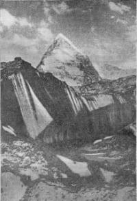
Alpinist Peak in Western Kokshaal-Too ridge.

Peaks of Western Kokshaal-Too.
“Who wants to be alone in trouble?
Who wants to leave without heeding my heart?
But we descend from the conquered peaks, -
What to do - and the gods descended to earth"
Vladimir Vysotsky. “Farewell to the Mountains”.
Climbing Alpinist peak in Western Kokshaal-Too ridge.
Alpinist Peak 5462 meters above sea level is located in the upper reaches of the Chon-Turasu River in the Western Kokshaal-Too ridge in the Naryn region. From August 1 to September 1, 1933, tourists from the Moscow House of Scientists under the leadership of August Letavet visited and described glaciers in the central part of the Western Kokshaal-Too ridge near Dankov Peak.
Letavet gave the names to the peaks, one of the peaks in the upper reaches of the Chon-Turasu glacier they named Alpinist. The expedition visited previously unknown gorges and mapped new glaciers and peaks.
The view of the travelers opened up a view of the upper reaches of the Chon-Turasu gorge with an amazingly beautiful peak that looked like a regular pointed pyramid, which abruptly drops downward by severe rocky walls.
The delighted Letavet gave this peak the name Alpinist Peak. Soon after the end of the expedition, already in Moscow, one of its participants, a doctor, died, and in memory of him, one of the peaks in the Chon-Turasu gorge was named Maron Peak. A. Letavet's expedition named the right (eastern) glacier Chon-Turasu - the Explorers' glacier.
The first sports mountaineering team that visited the Chon-Turasu gorge was an expedition of climbers of the Moscow region in the summer of 1969, organized by the Moscow Regional Sports Council and the Committee for Physical Culture and Sports of the city of Kaliningrad, Moscow Region.
Team composition: A. Korsun - captain, V. Penchuk - deputy captain, V. Gladchenko, E. Korenev, Valery Kremena, A. Kurshin, O Fedorov, and A. Yanochkin, Levon Alibegashvili, Stas Okhrimenko, L. Vorobiev, Veniamin Ivanov.
In 1993, the first ascent to the Alpinist peak was made. The main ridge of the Kokshaal-Too ridge is crowned with the Molodezhnaya (Druzhba) peak, 5330 meters above sea level, a small ridge 5 kilometers long extends from it to the north.
Alpinist peak is located in the middle part of this ridge. The ridge is located between the Dankov peak massif located to the west of the Alpinist peak at a distance of 4.1 kilometers. In the neighboring ridge extending to the northeast, there is a massif with a dominant peak of Sergei Korolev (Tourist), 5816 meters above sea level.
To the west of the Alpinist ridge is the left (western) branch of the Chon-Turasu glacier, to the right (eastern) branch of the Chon-Turasu glacier. Peak Sergei Korolev (Tourist) is located in the northeast of the Alpinist peak, 4.5 kilometers. Joldash (Chon-Turasu) peak is located 4.7 kilometers to the north-west at a height of 5729 meters above sea level.
Geographic coordinates of Alpinist peak: N41 ° 03'06.37 "E77 ° 43'48.88"
Authority and photos by
Alexander Petrov.
Defeated peaks. 1968 - 1969. Publishing house "Mysl", Moscow, 1972. "In Western Kokshad-Tau". Korsun A., Povarnin P.


