


![]()
You are here
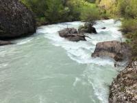
Baldabrek River.
Rivers of Ugam Range.
“We had not yet traveled a hundred meters when we noticed white butterflies flying around. Getting off the horse and catching one of them was a matter of moments. But what was my joy when I recognized in this butterfly the rarest representative of the genus Parnassius, the famous Apollonius, so far found in only one specimen by the Fedchenko expedition.”
S. Alferaki. “Kulja and Tien-Shan.” 1879.
Right tributaries of Sairam-Su River.
Baldabrek River is 48 kilometers long and is a left tributary of Sairam-Su River. It originates from northern slope of Ugam Range. For 17 kilometers, river flows through territory of Aksu-Zhabagly Nature Reserve and is located in Tolebi District of Turkestan Region.
Baldabrek River is a typical mountain river in the Aksu-Zhabagly Nature Reserve, fed by snow and glaciers. The sources of the Baldabrek River are located in a huge cirque on the northern slope of the Ugam Range. In the vicinity of the Korumtor Pass, the Baldabrek Mountains branch off from the Ugam Range to the northwest.
They separate the basins of the Aksu and Baldabrek Rivers, and one of the mountain spurs serves as a watershed between the Baldabrek and its tributary, the Bala Baldabrek, which passes slightly to the north. At the 8th kilometer from the beginning of the sources, the river at an altitude of 2282 meters above sea level forms the main channel, consisting of 4 tributaries in the upper reaches.
The left tributary Baldarbek Zapadny with a length of 5 kilometers originates from a small glacier of the same name with a length of 2.3 kilometers, the area of the glacier reaches 1.39 square kilometers. The glacier is located on the northern slope of the Ugam ridge.
The upper boundary of the glacier is located at an altitude of 3937 meters above sea level, the tongue of the glacier is at an altitude of 3480 meters above sea level. The sources of the river are located at an altitude of 3925 meters above sea level, the mouth of the river is at an altitude of 1024 meters above sea level.
At the 15.5th kilometer from the beginning of the sources, the Baldabrek River flows through the unique rocky "gates" of Darbaza, which are a natural landmark in the Aksu-Zhabagly Nature Reserve. The narrow, rocky gates more than 100 meters deep and only 6 - 8 meters wide were cut in the high mountain range by the Baldarbek River.
This place is called Darbaza, which means "gate" in Kazakh. On a hot summer day, the narrow gorge is always cool from the river freshness in the shade of huge rocks decorated with bizarrely hanging plants. At the 33rd kilometer, the river begins to disintegrate into ditches and canals Bibaishy, Kokayryk, Zhamanzhar, Kyraryk, Olzhaly and others, one of them is the large main channel Kyzylasker.
The flood duration of the Baldabrek River is 140-200 days (from March to September), with a maximum in June-July. Yellow Greig tulips grow in the remote upper reaches of the Baldabrek and Bala-Baldabrek rivers. In some areas, there is an extraordinary variety of tulip flower colors with various transitions from red to yellow. Here, almost every individual is a form different from the others.
Geographic coordinates of Baldabrek River: N42 ° 15'09 E70 ° 28'30
Bala Baldarbek River.
At the 14.5 kilometer mark, the river flows through the Shuyldak valley, in which a meteorological station is located 1.3 kilometers from the right bank of the river. At the 25th kilometer mark, the Bala Baldarbek River flows from the right, with a length of 22.5 kilometers.
At the 14.5 kilometer mark, the river flows through the Shuyldak valley, in which a meteorological station is located 1.3 kilometers from the right bank of the river. The river sources are located at an altitude of 3690.9 meters above sea level, the mouth of the river is at an altitude of 1479 meters above sea level.
The northern slope of the Bala Baldarbek River is steep and sheer, and in places forms a canyon-like bed. The sources of the Bala Baldabrek River are located in two gorges, parallel to each other and separated by a spur of the Baldabrek peak, 3,694 meters above sea level.
Both gorges end in glacial cirques, of which the right one, where the Burevestnik-II pass is located, is semi-hanging. The ascent along the gorge leads along three moraine shafts, each 100 - 150 meters high.
Geographic coordinates of Bala Baldabrek River: N42°17'04 E70°26'16
Zhailausay River.
At the 43rd kilometer from the beginning of the sources, the Zhailausay tributary flows into the Baldyrbek River from the left, 23.3 kilometers long. After 1.6 kilomters from the beginning of the sources, the river reaches Lake Chumkuldyk (Yarmukhamedov).
The lake is located at an altitude of 1796.7 meters above sea level, is located in the valley of the Zhailausay River. The length of the lake from southwest to northeast is 96 meters, the greatest width in the eastern part reaches 45 meters. The area of the lake is 3243.12 square meters, the length of the coastline is 283.81 meters.
Individual trees grow around the lake, juniper grows lower along the riverbed. The lake is inhabited by marinka. After 7.6 kilometers, two tributaries merge and the main channel is formed on the river.
Geographic coordinates of Lake Chumkuldyk (Yarmukhamedov): N42°13'27 E70°23'25
Geographical coordinates of Zhalusai River: N42°14'33 E70°13'53
Authority and photos by:
Alexander Petrov.
https://titus.kz/?previd=100340