


![]()
You are here
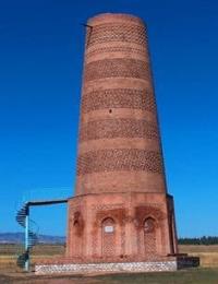
Burana Minaret and Watchtower.
Visit of minaret of Burana Tower.
"In the Chu Valley, near the city of Balasagun (see (above, p. 355), up until the Mongol conquest, there was the residence of most of the nomadic rulers of Turkestan, both the Muslim Ilek Khans (or one of the branches of this dynasty), and from the 6th to the 12th centuries, the pagan conquerors from the Kara-Khitans. Almost all the conquerors of East Asian origin who devastated the western part of Central Asia passed through this region."
Academician V.V. Bartold. "Works on Historical Geography." 1965.
Tours to Kyrgyzstan Monuments.
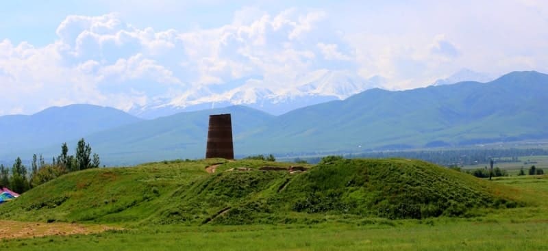
Architectural structure of minaret and watchtower of Burana is located at an altitude of 938 m. a. s. l., is located in eastern part of Burana settlement, on territory of architectural and archaeological complex of same name, 12 kilometers south of city of Tokmak, on territory of ruins of Burana settlement in Chuisky area of region of same name.
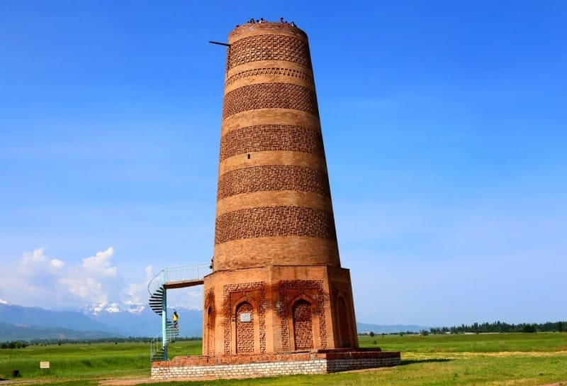
According to scientists, the tower was built in the XIth century. The architectural structure of the Burana Tower served as a minaret and a watchtower. The surviving Burana minaret once belonged to the cathedral mosque. It was built in the newly rebuilt city at the end of the Xth or beginning of the XIth century during the period of mass Islamization of the Semirechye Turks.
This is the earliest surviving monument of tower architecture in Central Asia. Archaeological surveys and excavations at the minaret were carried out in 1925, 1960 and 1970 - 1974. The structure of the underground part of the structure was revealed, consisting of a powerful foundation in the form of a powerful platform made of stone and burnt brick, with sides of 12.3 meters and a pit depth of 5.6 meters.
The above-ground part of the minaret was erected on this foundation: an octagonal two-step base and a thinning cylindrical trunk, preserved for 22 meters. The doorway is located at the 5-meter mark, the entrance to it was supposed to be via a ladder, or from the roof of the lost mosque building, a spiral staircase led up.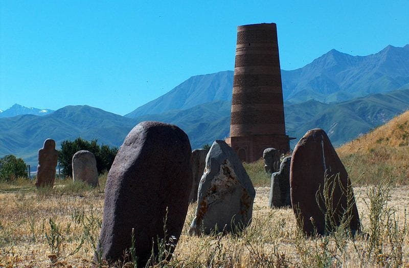
The top of the minaret was lost in antiquity (Masson, Goryacheva, 1985, pp. 49 - 50). The building is made of burnt bricks of different sizes with the introduction of figured carved bricks into the masonry. Its decor consists of alternating ornamental and smooth masonry belts, which is typical for most Central Asian minarets.
The cathedral mosque to which the minaret belonged has not survived and it was apparently destroyed before the first mentions of the monument in literature. Around the minaret, traces of a rampart are visible, enclosing a rectangular area with sides of 560 meters and 480 meters.
Twenty meters to the north from the minaret there is a swollen hill up to 10 meters high: these are the ruins of an ancient building. Obviously, the minaret stood in the center of an ancient settlement. The settlement where the minaret stood is also not the only one in this area.
To the north of it, about six kilometers away, where the railway runs, even more monumental ruins of a large fortress city are visible. It has been established that these ruins belong to the ancient city of Balasagun. This minaret is called the Burana Tower.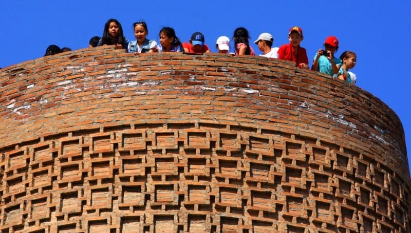
Article by A.N. Bernshtam “Burana Tower is a minaret of XIth century. Architectural monuments of Kyrgyzstan. 1950.
“There is not a single resident of the Chui Valley who would not know that not far from the city of Tokmak there is a “tower” called the Burana Tower. This name belongs to a majestic minaret built about 900 years ago. The name “Burana” is most likely most likely, comes from the incorrectly pronounced word "monara", i.e. minaret.
A minaret is an obligatory part of a mosque; it is a tower from which the muezzin (azanchi) called Muslims to the next prayer. Many years have passed since the Burana minaret was built; the people forgot what it served for, the mosque that stood next to the minaret fell apart, and the minaret began to be perceived either as a watchtower or as part of a castle, where a once powerful khan hid his daughter from the eyes of people who wanted to take her as a wife.
Written sources also say little about this building, and only a special examination of this monument by archaeologists and architects made it possible to establish why it was erected here, what this first-class building for its time reminds us of. To the east of the Burana minaret there is a river of the same name that dries up in the summer.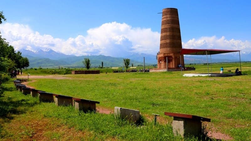
Around the minaret there are traces of a rampart that enclosed a rectangular area with sides of 560 and 480 meters. Twenty meters to the north of the minaret there is a swollen hill up to 10 meters high; these are the ruins of an ancient building.
Obviously, the minaret stood in the middle of an ancient settlement. The settlement where the minaret stands is also not alone in this area. To the north of it, about six kilometers away, where the Kant-Rybachye railway runs, even more monumental ruins of a large fortress city are visible.
Archaeologists who have explored these places have established, through excavations and studying ancient written sources, that these large ruins belong to the ancient city of Balasagun. At first, in the VIth - Vth centuries, there was the headquarters of the Turgesh kagan (king) and a colony of Sogdians (ancestors of the Tajiks who moved from the Zeravshan River basin to the Chui Valley in the Vth - VIIth centuries AD) and the area was called Kuz Ordu.
Later it was called Balasagun (in the XIth - XIVth centuries), but for a short period of time (from 1117 to 1218), when this city was conquered by the Kara-Khitans - a people who came from the east, it was their capital and was called Khosun Ordu.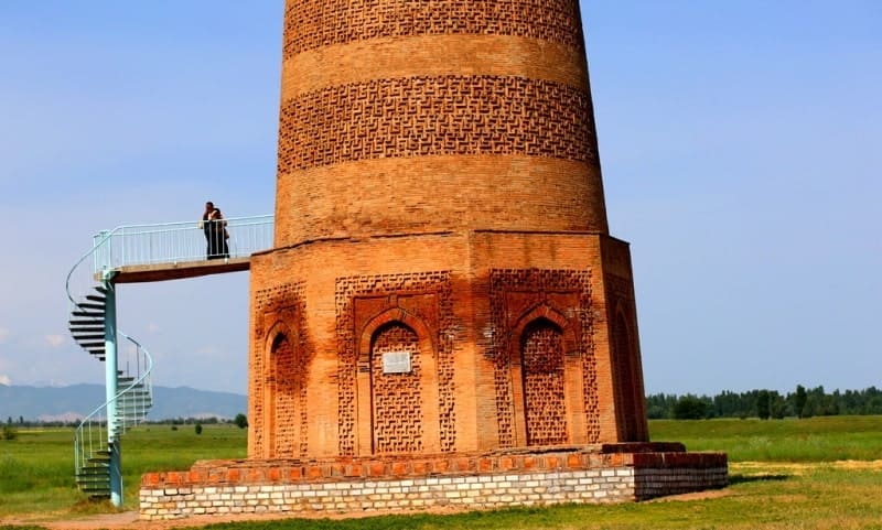
Finally, having been conquered at the beginning of the XIIIth century, more precisely - in 1218, by the Mongols, it was renamed by them into Gobalyk, i.e. literally - "good city". In the XIVth century, the city ceased to exist. The inhabitants left it, and it began to collapse more and more.
The walls of the fortress and ramparts sagged, washed away by the rain and fluttered by the wind, and by the beginning of the XVI th century they had taken on the appearance of complete desolation, in which they are now. The greatest prosperity of the city occurred in the XIth - XIIth centuries; then it was the capital of all Central Asia, first of the Turkic dynasty of the Karakhanid, then of the Kara-Khitans.
The borders of the empire stretched from Xinjiang to the Amu Darya. In Balasagun sat the kings, they were surrounded by scholars; one of them - Haji Yusuf Balasagunsky - became widely famous for his work entitled "Kudatgu Bilik", i.e. "Knowledge of how to become happy", a guide for the sovereigns of the East.
He wrote this book back in 1069, but it was known much later - in the XIVth century, known not only in the Chui Valley, but also in Egypt and on the Volga. In Balasagun and its suburbs there were temples - Muslim under the Karakhanids, Buddhist under the Kara-Khitans, and later - Christian. In one of the suburbs of Balasagun, which was called "Kirmirau", a mosque with a minaret was built at the very beginning of the XIth century; the rampart of the ancient city and the hill with the remains of the mosque have been preserved. Only one minaret has survived the centuries. This minaret is called the Burana Tower.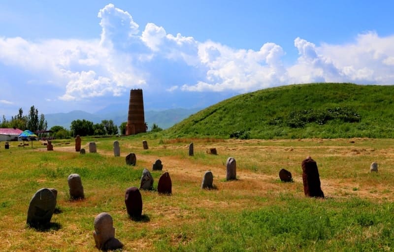
What is Burana Minaret?
The minaret with a total height of 21.6 meters stands on an octagonal base 3.75 meters high. The trunk of the minaret slightly narrows towards the top. At the base, its diameter is 8.85 meters, at the top - 5.90 meters. The minaret is built of bricks measuring 25 x 25 x 5 cm.
On the southern side of the minaret, at a height of 5 meters above the ground, there is an entrance 1.50 meters high, with a width of 65 cm. Inside the minaret, a spiral staircase runs in a spiral. The high steps (up to 40 cm) have been partially preserved - only 32 in number, but previously there were, apparently, twice as many.
A very narrow staircase (its height is up to 70 cm) is covered with a semicircular vault. At a height of 12.6 meters there is a small lancet window - 1.10 x 0.50 meters in size, sharply narrowing towards the outer side, like a loophole in a fortress, reaching a size of 0.50 x 16 cm.
Inside the staircase there are Arabic inscriptions scratched into the brick, but they are badly worn and damaged, which makes it very difficult to decipher them. The brick from which the minaret is built is also used to lay out the ornament that decorates its outer surface.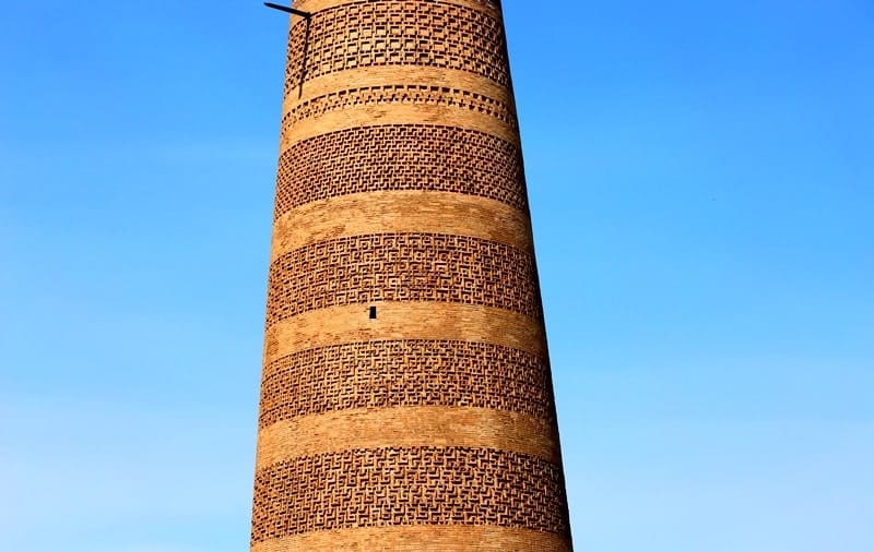
The figured brickwork forms ornamental belts, partially including meander weaving. On the edges of the basement, the same brick and in the same manner are used to lay out lancet false arches, the inner field of which is filled with the same ornament as on the upper belts of the minaret - in the form of lines intersecting at right angles.
It would seem that the Burana Minaret contains little information, but it nevertheless says a lot. The Burana Minaret has a very characteristic execution of the external decoration; the brick from which the building itself was built was used to decorate the external surface; the brick is not decorated with either carving or colored glaze.
The master, pushing forward in a certain sequence the narrow end side of the brick against the background of smooth masonry, executed a pattern of a certain content. Such a pattern of figured brickwork is sometimes called "textile" ornament in the architecture of Central Asia.
The technique of decorating a building, where the decorative masonry is part of the structural, and the geometric plot dominates in the ornament of the decoration, is an old architectural technique for Central Asia and dates back to the end of the Xth and the beginning of the XIth century.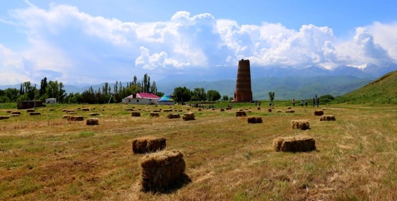
The Xth century structure is executed in this manner - the Ismail Samani mausoleum in Bukhara, the large minaret in Bukhara, the Vabkent minaret, the Uzgen minaret, the middle mazar in Uzgen and other architectural monuments of Central Asia - basically all monuments of the first half of the XIth century.
This similarity of the structural and decorative features of the Burana minaret with a number of structural techniques used in the above-mentioned monuments makes researchers attribute the construction of the minaret to the beginning of the XIth century.
Taking into account the archaism of some construction techniques, as well as the nature of the handwriting of the Arabic inscription, researchers come to the conclusion that in a series of monuments erected by the rulers of the Karakhanid dynasty (Xth - XIIth centuries), the Burana minaret is one of the oldest. It can be assumed that when the Karakhanids came to power (in the second half of the Xth century; final confirmation in 999), they developed intensive construction of Muslim religious buildings, and one of them was not far from the capital - Balasagun, in the suburb of Kirmirau.
Over time, only one minaret remained as a memory for posterity, as a witness to the extraordinary construction skills of the architects of their time, who asserted the power of the Central Asian rulers with majestic buildings. In Central Asia, there are few monuments like the Burana minaret, and its value as a witness to the ancient culture of the peoples of Central Asia increases even more.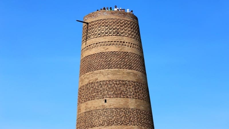
It was repeatedly examined and studied by scientists of our country; among them, as early as the end of the Xth century, - Academician V.V. Bartold, later, in the Soviet years, - Professors M.E. Masson and B.P. Denike and the author of this work.
A detailed description of the Burana tower was given by M.E. Masson, but his work never saw the light of day. For the work of M.E. Masson on the survey of this minaret, see: I.I. Umniko in “Architectural Monuments of Central Asia; see also “News of the Sredazkomstarns. Issue III. Tashkent, 1928, p. 270”.
Detailed information about the Burana tower is published in the Works of the expedition of the IIMK of the USSR Academy of Sciences and the Kirg of the USSR Academy of Sciences. Information about it is also available in the publications of I.I. Umnyakov and A.A. Semenov, and even earlier - V.M. Florinsky and a number of others. Back in 1927 - 1928, Soviet monument protection agencies carried out repairs to this remarkable structure with the participation of architect-restorers M.M. Loginov and N.M. Bachinsky.
And now the Burana Minaret as a first-class monument of cultural heritage is protected by the state. Among other values left to us from the past, the Burana Minaret occupies a very noticeable place, and everyone who comes to the ruins, standing alone near the mountains among the wide expanses of the Chui Valley, is imbued with a feeling so characteristic of Soviet people - a feeling of deep respect for the skill and work of the ancestors of the peoples of Central Asia."
Geographical coordinates of Burana Tower: N42 ° 44'46 E75 ° 15'00
Authority:
"Issyk-Kul. Naryn" encyclopedia, Frunze, 1991. "Kyrgyzstan", publishing house "Mysl", Moscow, 1977. A.N. Bernshtam "Burana Tower - a minaret of XIth century. Architectural monuments of Kyrgyzstan. 1950.
Photos by:
Alexander Petrov.