


![]()
You are here
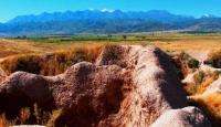
Burana settlement.
Early medieval cities and settlements in Chu River valley.
"In the Chu Valley, the Sogdians widely developed agriculture based on the ancient irrigation system, which used fast-flowing mountain rivers with a large slope. With a technically high level of agriculture, it became possible to grow crops such as rice, grapes, and dried apricots. Grapes first appeared in the Chu Valley at the beginning of the 7th century. Since that time, grain crops have been widely sown, especially barley and millet."
A.N. Bernshtam. "Architectural Monuments of Kyrgyzstan." 1950.
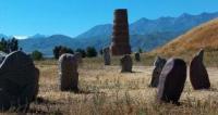
Stone settlements and settlements in Kyrgyzstan.
Burana settlement is named after the "Burana" tower located here. The settlement occupies a large depression along both banks of the shallow Burana River, 15 kilometers south of the city of Tokmak, on the eastern outskirts of the village of Don-Aryk.
The central ruins stand above the left bank of the Burana River. In plan, it is an irregular quadrangle, oriented with its sides to the cardinal points, which is surrounded by a sagging wall 4 meters high, 20 meters wide at the base. The rampart has not been preserved along the entire perimeter.
The southeastern corner and the eastern wall have been heavily eroded by the Burana River. The length of the surviving sides - northern and western - is 570 meters, the southern side is about 600 meters, and the eastern side is no more than 500 meters.
In the western wall, closer to the northwestern corner, one of the entrances, 15 meters wide, is clearly visible. The interior space of the central ruins is characterized by a weak filling of cultural layers and the presence of significant areas free of buildings.
The layers reach their greatest thickness in the southwestern corner, but even here they are much lower than the crest of the wall. An even lower platform of cultural layers is located along the eastern wall, where the Burana Tower stands. A separate small group of elevations is located somewhat to the west of the eastern platform.
A significant elevation is noted in the northwestern corner of the quadrangle. At present, it is built up with a poultry farm. Particularly striking are two large hills up to 15 meters high, standing 60-70 meters to the northwest of the Burana tower. They are surrounded by a platform and represent one complex measuring 100 x 100 meters.
The monumentality of these ruins allows us to disagree with the opinion expressed by A.N. Bernshtam that these are the remains of a mosque. Most likely, these are the ruins of a palace building. The distance (60-70 meters) from the "tower", which is a minaret, also speaks against identification with a mosque.
Approximately in the middle (from south to north) of the settlement there is a deep ravine, very similar to an ancient irrigation ditch. It is not the result of the destruction of waste water, since it originates immediately behind the southern wall of the central ruins.
In ancient times, the irrigation ditch originated from the Burana River and supplied the most fortified part with water. In the southwestern corner, a large khauz can be seen, which served as a water reserve. The northeastern sector of the quadrangle has no traces of buildings.
There was also a free space opposite the main entrance in the western wall. Around the central ruins and the small buildings surrounding them, there were two concentric rings of walls, of which the outer one has been preserved more completely.
The inner one does not have a western arc, and both rings have not survived in the southwestern part, in the floodplain of the Burana River, where they were probably washed away. Both rings in the surviving parts do not run parallel to each other.
The distance between them in the northern part is 350 meters, in the eastern part - 850 meters, and in the southern part - 400 meters. In the eastern part, between the "concentric" ramparts in the direction from east to west, there is a connecting rampart.
The height of the outer rampart is 1.5 - 1.7 meters almost along its entire length, the width at the base is 14 meters. The inner rampart reaches such dimensions only in the eastern part, in the northern and southern parts its height is 1 meter. The total length of the preserved outer rampart is 11 kilometers, if you add to this the measurement of the gap in a straight line between the ends of the rampart, you get a figure of about 15 kilometers.
The territory surrounded by these ramparts is almost entirely plowed for crops. Small areas, inconvenient for plowing, have preserved the remains of buildings of different sizes. Excavation work on the settlement was carried out both on the central ruins (4 excavations) and beyond them (1 excavation).
In addition, three cuts were made in the walls: the central ruins, as well as the first and second long rings. The excavation on the central ruins north of the Burana tower (with an area of 8 square meters) cut through a cultural layer 2.2 meters thick.
The layers consist of loess and clay layers of different shades and pavements of large stones. Ceramic material is numerous. It is characterized by the complete predominance of easel ware of high manufacturing technology. Hand-moulded ware is found in the lowest layers.
Ease-moulded ware is represented by many forms and in a large number of examples:
a) large deep bowls (up to 35 cm in diameter) with a flat rim, along which there are bundles of wavy lines;
b) thin-walled small bowls like a bowl with a rounded edge;
c) small bowls with loop-shaped handles;
d) elegantly profiled jugs with a high narrow neck, a knee-shaped vertical handle and a stamped ornament of triangles and circles along the shoulders;
d) regular shaped pots with a slightly bent rim, etc.
The molded ware is represented by several fragments of the walls of well-fired vessels. The excavation on the central ruins, in the southwestern corner, on the highest platform (8 square meters) cut through layers 2.5 meters thick. It is impossible to stratigraphically divide the layers into separate tiers.
The ceramic material, as in the first excavation, is characterized by high technique, perfect forms and an almost complete absence of molded ceramics. Among the easel ware, bowls of different sizes on a disc tray with loop-shaped handles and without them, a jug-shaped vessel, lamps, etc.
The glaze is dark and light green. It is of later origin than the white glaze with different colors of painting, dating back to the Karakhanid period and found in the lowest layers of the excavation. Unglazed easel ware repeats the diversity and perfection of the forms of ceramics from the first excavation.
Hand-moulded ware was found in single copies. The third pit (8 square meters in area) was laid on the lowest part of the central ruins in order to check for cultural layers here. It was established that this part of the interior space was free from buildings.
Only a few pieces of brick were found in the excavation. The fourth pit (of the same size) was broken in the western sector, on a slightly elevated platform. The layers consist of hard grayish-brown slabs. The finds are few: pieces of brick, a small fragment of a glazed vessel, small fragments of easel vessels.
They are synchronous with the materials from the other excavations. The layers indicate that there was no permanent building in this part of the central ruins either. The pit within the long wall (8 square meters in size) was dug on one of the small hills, about 2 kilometers to the east of the central ruins.
It cut through dense clay rubble with rare inclusions of small pebbles. In the northeastern part of the excavation (from the mark of 0.8 to 1.7 meters), a 0.7-meter wide adobe wall was cut, already standing on a cultural layer over 0.2 meters thick, belonging to the lower construction tier.
Other construction parts included individual fired bricks (24 x 4 x? cm) and adobe bricks (30 x 15 x 10 cm). Traces of a hearth were noted, the shape and size of which could not be restored. A significant proportion of the ceramic material is glazed ware - bowls with greenish-white and white glaze.
Unglazed easel ware included fragments of open vessels, narrow-necked jugs and sidewalls with comb ornamentation. Hand-molded ware is represented by single examples of fragments from vessel walls and lids. A section of the collapsed wall of the central ruins showed that it was erected from layers of pakhsa 10 to 20 cm thick and up to 7 meters wide.
The height preserved under the burrows reaches 3.5 meters. A section of the first long rampart revealed the remains of an adobe wall 3 meters wide, preserved to a height of 1.85 meters. A section of the second (outer) long rampart revealed the same adobe wall, over 3 meters wide, preserved to a height of 1.74 meters.
According to the topographic structure and stratigraphy, as well as excavation materials, the Burana settlement stands out from all the settlements with long walls that we have examined. On the one hand, the uniqueness of the plan, the absence of a citadel, weak cultural layers, the abundance of glazed pottery with an absolute predominance of easel pottery, indicate that the Burana settlement belongs to the very last period of the existence of settled settlements in the Chuya Valley.
It existed for some time even after the destruction of most other settlements as a result of the Mongol invasion, which is confirmed by the abundance of green glaze not found there. On the other hand, the perfection of the dishes, the presence of a magnificent architectural monument and the rare case of a settlement surrounded by two rows of long walls indicate that this was not an ordinary settlement. It has all the signs of a significant political center.
Authority:
P. N. Kozhemyako. "Early Medieval Cities and Settlements of the Chui Valley". Academy of Sciences of Kirghiz SSR. Frunze, 1959.
A. N. Bernshtam "Architectural Monuments of Kirghizia". USSR Academy of Sciences. N. Ya. Marr Institute of the History of Material Culture. Publishing House of USSR Academy of Sciences. Moscow - Leningrad. 1950.
Photos by:
Alexander Petrov.