


![]()
You are here
Chakyr-Korum River is left tributary of Naryn.
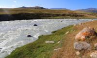
Rivers of Naryn region.
“Early in the morning on October 20, the Cossacks set off from Char-Karytma, sent to the Small Naryn; I had only a 7-verst transition to the Great Naryn, and there was nothing to hurry. Therefore, I began to sketch a majestic view from the Char-Karytma gorge to the ridges north of Naryn, rising in three ledges: the lower one is a small hillock, an undulating steppe with yellowed autumn grass, pitted in all directions by frequent hollows; behind it is a red sandstone rocky ridge, broken through by the Ottuk and the Small Naryn and giving rise to many small tributaries of the Big Naryn between the breakthroughs of these two, more significant ones; finally, still far behind on the horizon, a group of high snowy peaks, at the southern end of the Karakhodzhur and Small Naryn watershed."
N. Severtsov. "Journey through the Turkestan region and the study of the mountainous country of the Tien Shan." 1873
List of rivers of Kyrgyzstan.
Chakyr-Korum river basin consists of the following main rivers: Kuldzhator, Jagalmai, Turator, Koltor, Ayutor, Echkitor, Joolzhurek-Su, Kichinetor, Chontor, Chon-Kara-Su, Karabdur.
8.5 kilometers after the formation of the main channel of the Naryn River, a tributary of the Chakyr-Korum with a length of 36 kilometers flows from the left. The Jagalmay River, being the main tributary, flows for 10.7 kilometers, and after the confluence of the Kuldzhator tributary on the left, it receives the name Chakyr-Korum.
The river originates from the northwestern spur of the Borkoldoy ridge. The mouth of the river is located at an altitude of 3170 meters above sea level.
Geographic coordinates of river: N41°28'24.53" E77°37'29.84"
River Kuljator.
After 8.8 kilometers from the beginning of the sources of the Chakyr-Korum, a tributary of Kuldzhator with a length of 4.1 kilometers flows from the left. The sources of the Kuljator River originate from the southeast side of the dominant Kuljator peak, 4558.5 meters above sea level. There are no glaciers in the northwestern spur of the Borkoldoy Range. The mouth of the river is located at an altitude of 3667 meters above sea level.
Geographical coordinates of Kul'dzhator River: N41°26'16.50" E77°28'44.59"
Jaglamay river.
The length of the Jagalmay River is 10.7 kilometers; it is one of the main and full-flowing tributaries of the Chakyr-Korum River, which originates from the northwestern spur of the Borkoldoy Range. The main channel of the river is formed at an altitude of 3752 meters above sea level from two tributaries - northern and southern.
Before the confluence of the Kuljator on the left, the river receives one more tributary on the right and on the left. In the upper reaches of the Jagalmay gorge, on the northern slopes, there are small glaciers, from where the river receives its food.
Among them, the Jagalmay glacier is 1.7 kilometers long, the area of the glacier is 2.47 square kilometers, the perimeter of the glacier reaches 7.56 kilometers. The upper feeding area of the glacier lies at an altitude of 4472.8 meters above sea level.
The tongue of the Jagalmay glacier is located at an altitude of 3964 meters above sea level. The mouth of the river is located at an altitude of 3559 meters above sea level.
Geographical coordinates of Jagalmay River: N41°25'07.25" E77°27'37.96"
Turator river.
After 16.1 kilometers from the beginning of the sources of the Chakyr-Korum, a tributary of the Turator with a length of 6.8 kilometers flows from the right. The Turator River originates from the northern slopes of the spur of the Borkoldoy Ridge. In the upper reaches of the Turator gorge, on the northern slope, there are two small glaciers, from where the river is fed.
Among them, the Turator Vostochny glacier is 2.8 kilometers long, the area of the glacier is 4.65 square kilometers, the perimeter of the glacier reaches 11.25 kilometers. The upper feeding area of the glacier lies at an altitude of 4655 meters above sea level.
The tongue of the Jagalmay glacier is located at an altitude of 3995 meters above sea level. The mouth of the river is located at an altitude of 3557 meters above sea level.
Geographic coordinates of Turator River: N41°25'43.12" E77°32'26.52"
River Koltor.
After 17.8 kilometers from the beginning of the sources of the Chakyr-Korum, the Koltor tributary, 5.4 kilometers long, flows in from the right. The Koltor River originates from the northern slopes of the spur of the Borkoldoy Range.
In the upper reaches of the Turator gorge on the northern slope, there are two glaciers - Koltor East and Koltor West. The Koltor Wast glacier is 3 kilometers long, the area of the glacier is 1.97 square kilometers, the perimeter of the glacier reaches 7.5 kilometers.
The upper feeding area of the glacier lies at an altitude of 4789.4 meters above sea level. The tongue of the Koltor East glacier is located at an altitude of 3954 meters above sea level. The Koltor West glacier is 3 kilometers long, the area of the glacier is 3 square kilometers, the perimeter of the glacier reaches 7.78 kilometers.
The upper feeding area of the glacier lies at an altitude of 4789.4 meters above sea level. The tongue of the Koltor West glacier is located at an altitude of 3885 meters above sea level. The mouth of the river is located at an altitude of 3520 meters above sea level.
Geographic coordinates of Koltor River: N41°26'24.12" E77°35'00.09"
River Ayutor.
After 19.6 kilometers from the beginning of the sources of the Chakyr-Korum, the Ayutor tributary, 6.1 kilometers long, flows from the right. The Ayutor River originates from the northern slopes of the spur of the Borkoldoy ridge.
In the upper reaches of the Ayutor gorge, on the northern slope, there is the Ayutor glacier. The Ayutor glacier is 3 kilometers long, the area of the glacier is 2.92 square kilometers, the perimeter of the glacier reaches 12.5 kilometers.
The upper feeding area of the glacier lies at an altitude of 4761 meters above sea level. The tongue of the Koltor East glacier is located at an altitude of 3928 meters above sea level. The mouth of the river is located at an altitude of 3459 meters above sea level.
Geographic coordinates of Ayutor River: N41°26'23.35" E77°36'22.38"
Echkitor stream.
After 20.3 kilometers from the beginning of the sources of the Chakyr-Korum, a small tributary of the Echkitor, 1.6 kilometers long, flows to the right. The Echkitor stream originates from the northern slope of the Chakyr-Korum gorge. The mouth of the river is located at an altitude of 3443 meters above sea level.
Geographical coordinates of Echkitor stream: N41°27'18.02" E77°36'51.40"
Joolzhurek-Su river.
After 21.8 kilometers from the beginning of the sources, a tributary of the Joolzhurek-Su with a length of 6.4 kilometers flows into the Chakyr-Korum from the left. The Joolzhurek-Su river originates from the southern slope of the Chakyr-Korum gorge at an altitude of 4732 meters above sea level. The mouth of the river is located at an altitude of 3435 meters above sea level.
Geographic coordinates of Joolzhurek-Su River: N41°27'51.24" E77°35'34.42"
River Kichinetor.
After 21.8 kilometers from the beginning of the sources, the tributary Kichinetor, 3.8 kilometers long, flows into the Chakyr-Korum on the right. The Kichinetor River originates from the northern slope of the Chakyr-Korum gorge at an altitude of 4286.6 meters above sea level.
In the upper reaches of the gorge there is a small glacier Kichinetor with a length of 1.1 kilometers, the area of the glacier is 0.43 square kilometers, the perimeter of the glacier reaches 2.54 kilometers. The upper feeding area of the glacier lies at an altitude of 4732 meters above sea level.
The tongue of the Koltor East glacier is located at an altitude of 4083 meters above sea level. The mouth of the river is located at an altitude of 3435 meters above sea level.
Geographical coordinates of Kichinetor River: N41°27'35.28" E77°37'48.90"
Chontor river.
After 23.9 kilometers from the beginning of the sources, the Chontor tributary, 9.5 kilometers long, flows into the Chakyr-Korum on the right. The Chontor River originates from the northern slope of the Chakyr-Korum gorge. In the upper reaches of the Chontor gorge on the northern slope there are two glaciers - Chontor East and Chontor West.
The Chontor East glacier is 3.9 kilometers long, the area of the glacier is 2.12 square kilometers, the perimeter of the glacier reaches 8.99 kilometers. The upper feeding area of the glacier lies at an altitude of 4665 meters above sea level.
The tongue of the Koltor East glacier is located at an altitude of 3991 meters above sea level. The Chontor Western glacier is 4 kilometers long, the area of the glacier is 3.64 square kilometers, the perimeter of the glacier reaches 11.88 kilometers.
The upper feeding area of the glacier lies at an altitude of 4885 meters above sea level. The tongue of the Koltor Western glacier is located at an altitude of 3970 meters above sea level. The mouth of the river is located at an altitude of 3405 meters above sea level.
Geographic coordinates of Chontor River: N41°26'04.37" E77°39'30.22"
Chon-Kara-Su river.
The Chon-Kara-Su river basin consists of two rivers - Kara-Su and Karabdur. After 28.7 kilometers from the beginning of the sources of the Chakyr-Korum, a tributary of the Chon-Kara-Su with a length of 9 kilometers flows from the right.
The sources of the river are located at an altitude of 4182.1 meters above sea level on the western slope of the northwestern spur of the Borkoldoy ridge. There are no glaciers in the Chon-Karasu-Su gorge. The mouth of the river is located at an altitude of 3317 meters above sea level.
Geographic coordinates of Chon-Kara-Su River: N41°28'42.76" E77°43'49.77
Kara-Su river.
Kara-Su River, 9.1 kilometers long, is the left tributary of the Chon-Kara-Su River. The river bed is formed in the upper reaches of three tributaries. The eastern tributary of the Kara-Su originates at an altitude of 4841 meters above sea level from the Kara-Su East glacier with a length of 3.4 kilometers.
The area of the glacier is 1.68 square kilometers, the perimeter reaches 7.12 kilometers. The upper part of the glacier feeding area is located at an altitude of 4841 meters above sea level. The tongue of the glacier is located at an altitude of 3946 meters above sea level.
The remaining two sources originate from an intermediate spur at an altitude of 4710 meters above sea level in the interfluve of Kara-Su and Chon-Kara-Su from two narrow gorges in the upper part, which are located minor glaciers. The mouth of the river is located at an altitude of 3314 meters above sea level.
Geographic coordinates of Kara-Su River: N41°27'44.48" E77°43'44.54"
Karabdur river.
Karabdur River, 5.5 kilometers long, is the left tributary of the Chon-Kara-Su River. The river receives its sources from two small glaciers located on the northern slope of the Chakyr-Korum gorge - Eastern and Western Karabdur.
The length of the Karabdur Vostochny glacier is 1.9 kilometers, the area of the glacier is 0.94 square kilometers, the perimeter reaches 5.16 kilometers. The upper part of the glacier feeding area is located at an altitude of 4869 meters above sea level.
The tongue of the glacier is located at an altitude of 3985 meters above sea level. The length of the Karabdur West glacier is 880 meters, the area of the glacier is 0.37 square kilometers, the perimeter reaches 2.35 kilometers.
The upper part of the glacier feeding area is located at an altitude of 4869 meters above sea level. The tongue of the glacier is located at an altitude of 4171 meters above sea level. The mouth of the river is located at an altitude of 3392 meters above sea level.
Geographic coordinates of Karabdur River: N41°27'38.40" E77°41'38.14"
Authority and photos by
Alexander Petrov.