


![]()
You are here
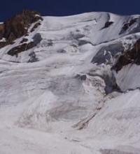
Glacier of Petrov in Ak-Shyirak ridge.
Tourist travel to mountains in Kyrgyzstan.
"The surveyor Petrov, who worked in the expedition of A.V. Kaulbars in 1869, mapped a short but powerful ridge, Ak-Shyirak (up to 5125 m), and discovered a number of huge glaciers there; the largest (about 17 kilometers) was named after him. He also found out that the Naryn River originates from the Petrov Glacier"
Magidovich I.P. "Essays on History of Geographical Discoveries".
"After a day of rest, we made a hike to the Petrov Glacier, which gives rise to the main source of the Syr Darya River. This glacier is flat, with a calm surface almost devoid of moraine cover. Movement along it was fast. It was soon discovered that the glacier has a powerful left (southern) branch, not marked on the maps and having almost the same length and thickness as the main one. This left branch also joins the Karasai glacier, as we discovered earlier during the ascent. 1932."
A. A. Letavet. "Ten Journeys in Mountains of Central Asia." 1932.
Travel from Issyk-Kul lake to Karakol.
Petrov Glacier is located on northwestern slope of Ak-Shyirak ridge, located in Jety-Oguz district of Issyk-Kul region.
The largest glacier in the northeastern part of the Ak-Shyirak massif is the complex valley glacier Petrov, consisting of: Petrov East Glacier, Petrov West Glacier and Petrov North Glacier.
Petrov East Glacier.
Is 13.6 kilometers long, with an area of 24.3 square kilometers, and a perimeter of 31.48. The upper boundary of the glacier is at an altitude of 5100 m. a. s. l.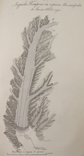
Petrov West Glacier.
Is 11 kilometers long, has an area of 26.55 sq. km.s, and a perimeter of 36.51. The upper boundary of the glacier is located at an altitude of 4916.8 m. a. s. l.
Petrov North Glacier.
Is 6.8 kilometers long, has an area of 15.39 square kilometers, and a perimeter of 27.8. The upper boundary of the glacier is located at an altitude of 4800 m. a. s. l. The upper boundary of the glacier feeder lies in a deep longitudinal valley between the northern and middle ridges of Ak-Shyyrak and through several high saddles connects with the firn basin of the Djaman-Su glacier in the northeast and with the Northern Kara-Sai glacier in the southwest.
There is a lake below the end of the glacier. In the mid-1950s, the lower 4.6 square kilometers of the lower part of the glacier were dead ice with deep canyon-like stream beds and an abundance of thermokarst funnels.
History of study of Petrov Glacier.
The glacier was named after the topographer, one of the participants in the expedition of Alexander Vasilyevich Kaulbars in 1869. In 1925, the Board of the Central Asian Meteorological Institute commissioned Lev Konstantinovich Davydov to organize an expedition to the Petrov Glacier. T
he objectives of this expedition were as follows. It was proposed to initiate systematic observations of the life of the Petrov Glacier and a group of adjacent glaciers in order to study the relationship between changes in these glaciers and the regime of the Naryn River on the one hand, and on the other, to identify the influence of meteorological factors on the life of these glaciers.
Here is how head of expedition L.K. Davydov describes Petrov Glacier.
“This glacier is characterized by a strong development of the feeding area in comparison with the area of the tongue. The lower part of the glacier is covered with transverse cracks, glacial tables and melting funnels.
The ice surface in this part is heavily littered with moraine material, represented by blocks and fragments of mainly gray granite. The glacial tongue ends in Lake Petrov located at an altitude of 3730 m. a. s. l., to which the youngest, not yet sodded, terminal moraine adjoins.
The second terminal moraine stretches parallel to the first. It is partially sodded, with remnants of dead ice. The third, most ancient moraine is the farthest from the glacier in the western direction. The ramparts of the terminal moraines rise several tens of meters above the valley floor.
They consist of a disorderly pile of small and large granite blocks. The Kumtor River valley below the Petrov Glacier was developed by more ancient glaciation. It is lined with moraine and fluvioglacial deposits."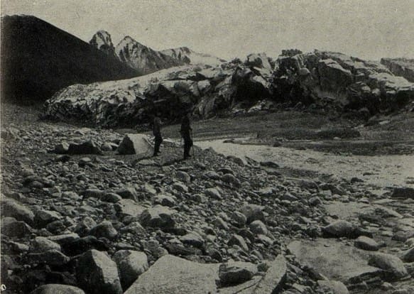
In 1933, the Petrov Glacier was explored by the glaciological detachment of the Naryn-Khantengri Expedition. The expedition consisted of: leader S. V. Kalesnik, his deputy S. V. Epstein, research associates A. Kh. Zavadovsky, N. V. Bykova, D. V. Epstein, S. P. Vorobyov, E. I. Nefedov and V. A. Tyurin.
The Naryn-Khantengri Expedition, which formed the Glaciological Detachment of the Kyrgyz Complex Expedition, was organized with funds and on the instructions of the USSR Committee for the II International Polar Year. The objects of study were to be: one of the major centers of glaciation in the central Tien-Shan – the Ak-Shiyryak ridge, which is a watershed between the basins of the Naryn (Syr Darya) and Sary-Dzhas (Tarim) rivers, and the adjacent high-mountain valleys – “syrts”.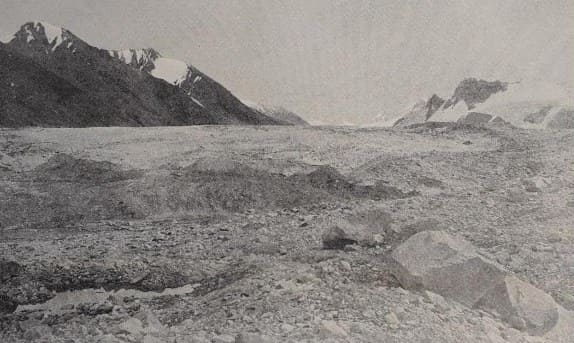
After a long organizational period in Frunze and Karakol, the expedition managed to leave Karakol for the mountains on August 3. The first task of the expedition was to set up a temporary meteorological station in the firn field of the Petrov Glacier at an altitude of 4250 m to assess the feeding conditions of the glaciers.
On August 14, the station was set up, for which it was necessary to lift half a ton of cargo by pack caravan 12 km up the glacier, consisting of a tent, felt mats, meteorological instruments, food, kerosene and personal equipment of two employees who had to remain in these snow fields for a whole month.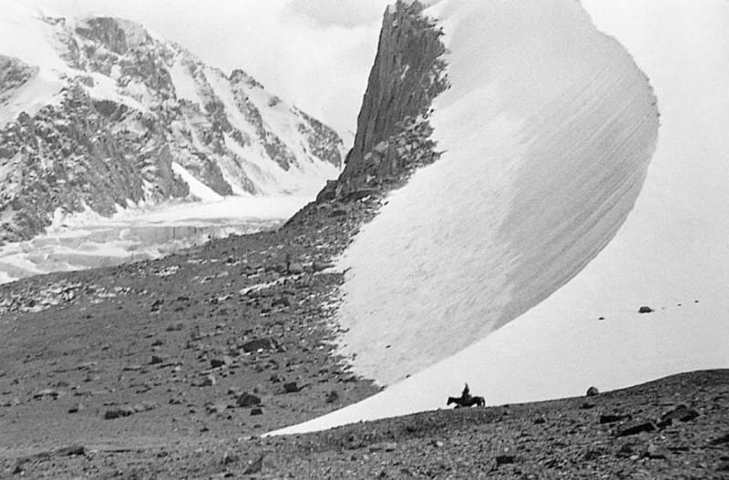
The station functioned until September 15 and made a number of interesting observations, especially valuable because until then no station operated by people had worked at such an altitude in the USSR. In 1957, traces of glacier activation were visible. Later, after a short revival, the glacial tongue died again.
The valley of the Kara-Sai River, penetrating deep into the massif, has significant glaciation.
Geographical coordinates of Petrov Glacier North: N41°54'54 E78°18'37
Geographic coordinates of Petrov East Glacier: N41°53'24 E78°19'04
Geographic coordinates of Petrov Glacier West: N41°51'30 E78°16'33
Authority:
"Glaciers." L.D. Dolgushin, G.B. Osipova. Series "Nature of the world." Moscow, the publishing house "Thought". 1989.
N.M. Prokopenko. "Crossing the Central Tien Shan along the route Karakol - Uzengegush - Naryn".
Leningrad, Publishing House of the Academy of Sciences of the USSR, 1933.
Photos by:
Alexander Petrov.