


![]()
You are here
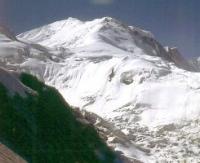
Glaciers of Ishkashim Range.
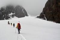
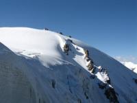
Tours in the mountains of Ishkashim Range.
“Multiplying knowledge,
Aliens visit the edges
I consider it a good deed.”
Brant Sebastian.
A trip from Khorog to Ishkashim.
The Ishkashim ridge stretches 120 kilometers from the mouth of the Gunt River in the north along the Pyanj River to its sharp turn in the area of the city of Ishkashim in the south. On a low northern section of the ridge (average altitude 4630 meters above sea level), on the slopes of ancient circuses, there are small kar glaciers.
To the south, the height of the ridge increases and reaches its highest values in the area of Myakovsky peak, where it adjoins the Shakhdarinsky ridge. To the south, over 40 kilometers, the average height of the ridge is 5560 meters above sea level, its slopes are dissected by deep gorges.
The ridges of the ridge are entirely occupied by glaciers. In total, there are 314 glaciers on the Ishkashim ridge with a total area of 164.5 square kilometers. Of them in the west slope 136 glaciers with an area of 46.7 square kilometers, the rest - on the eastern slope.
On the valley glaciers account for 60% of the glaciation area on the western slope and 80% in the east. The largest glacier - the Daray-Darshai (6.3 kilometers long, 11.2 square kilometers) - is located at the junction of the Ishkashim and Shahdarinsky ranges.
The glacier ends at an altitude of 4560 m meters above sea level, the height of the firn line is 4880 meters above sea level.
The total area of glaciation of the Ishkashim Range is about 170 square kilometers.
The largest glaciers of the Ishkashim ridge.
The Tangjirau Glacier, with a length of 5.8 kilometers, an area of 5.1 square kilometers, located at an altitude of 4830 to 5800 meters above sea level, belongs to the Dara-Tangjirau River Basin.
Glacier 873 with a length of 6.0 kilometers, an area of 4.4 square kilometers, located at an altitude of 4300 to 5300 meters above sea level, belongs to a tributary of the Badomdara river basin.
Glacier 54 with a length of 5.0 kilometers, an area of 2.8 square kilometers, located at an altitude of 4320 to 5500 meters above sea level, belongs to the tributary of the Daray-Gandarv River.
The 4.8 km long Hanzek Glacier, an area of 4.8 square kilometers, located at an altitude of 4810 to 5900 meters above sea level, belongs to the Daray-Hanzek River Basin.
Glacier 882 with a length of 4.6 kilometers, an area of 6.4 square kilometers, located at an altitude of 4220 to 5200 meters above sea level, belongs to the Darmaizwan River Basin.
Gandarv Glacier with a length of 3.9 kilometers, an area of 3.8 square kilometers, located at an altitude of 4620 to 5500 meters above sea level, belongs to the tributary of the Daray-Gandarv River.
Churzh Glacier, 3.8 km long, 2.6 square kilometers long, located at an altitude of 4000 to 5520 meters above sea level, belongs to the basin, a tributary of the Churzh River.
Glacier 892 with a length of 3.7 kilometers, an area of 3.0 square kilometers, located at an altitude of 4680 to 5600 meters above sea level, belongs to the basin of the river Vesdara.
The Khurport Glacier, with a length of 3.3 kilometers, an area of 1.2 square kilometers, located at an altitude of 4900 to 5960 meters above sea level, belongs to the Daray-Khurport River Basin.
Glacier 127 with a length of 2.9 kilometers, an area of 1.6 square kilometers, located at an altitude of 4740 to 5400 meters above sea level, belongs to the basin of the tributary of the Daray-Romanit River.
Glacier 137 with a length of 2.7 kilometers, an area of 1.7 square kilometers, located at an altitude of 4800 to 5600 meters above sea level, belongs to the basin of the tributary of the Daray-Gaizek River.
Glacier 52 with a length of 2.6 kilometers, an area of 2.4 square kilometers, located at an altitude of 4760 to 5520 meters above sea level, belongs to the basin, a tributary of the Daray-Gaidarv River.
Glacier 902 with a length of 2.6 kilometers, an area of 1.4 square kilometers, located at an altitude of 4280 to 5060 meters above sea level, belongs to the Dasht river basin.
Glacier 123 with a length of 2.6 kilometers, an area of 0.8 square kilometers, located at an altitude of 4700 to 5390 meters above sea level, belongs to the basin of the tributary of the Daray-Romanit River.
The 2.4 km long Chot-Chot glacier, an area of 1.2 square kilometers, is located at an altitude of 5020 to 5960 meters above sea level, belongs to the Chot-Chot river basin.
Glacier 83 with a length of 2.4 kilometers, an area of 0.9 square kilometers, located at an altitude of 4760 to 5600 meters above sea level, belongs to the basin of the tributary of the Daray-Zend River.
Authority:
"Glaciers." L.D. Dolgushin, G.B. Osipova. Series "Nature of the world." Moscow, the publishing house "Thought". 1989.