


![]()
You are here
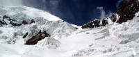
Glaciers of North Tanymas ridge.
Group tours in mountains of Tajikistan.
“No one comes back from a trip as it was before”
Chinese proverb.
Climbing tour in Tajikistan.
The North Tanymas ridge is located in the Murghab region of the Gorno-Badakhshan Autonomous Region of Tajikistan. The Northern Tanymas ridge stretches in the latitudinal direction for 62 kilometers from the middle course of the Fedchenko Glacier to the Takhta-Korum pass 4555 meters above sea level, separating it from the Zulumart ridge.
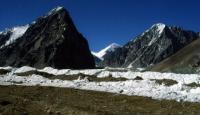
The highest point, Krutoy Rog peak 6018 meters above sea level, is located in higher western part of the ridge. The northern slope of the ridge is complicated by several spurs - watersheds between the left tributaries of the Balyandkiik river.
The largest of them is the Kyzkurgan Range and the Balyandkiik ridge. To the south of the North Tanymas ridge, the Aral ridge stretches parallel to it. The relief of the western part of the ridge is characterized by deep dissection, to the east, to the headwaters of the Balyandkiik river, there is a gradual transition to the relief of the Eastern Pamirs with a small relative height and less significant dissection.
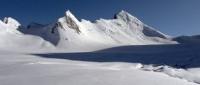
Firn height the line increases from 4700 - 4800 metro above sea level in the western part of the ridge to 500 - 5200 meters above sea level in the eastern ridge. Due to the high altitudes, a sufficiently large amount of precipitation of 800 - 1000 mm in the western part and the strong rugged terrain on the ridge North Tanymas main glaciation way to the higher western part of the ridge.
Total on the North Tanymas ridge with its spurs and on the Aral ridge 318 glaciers with a total area of 473.9 square kilometers. Of these, 22 glaciers with an area of 78.3 square kilometers belong to the Fedchenko Glacier basin, 171 glaciers with an area of 78.3 square kilometers belong to the Balyandkiik river basin (Muksu river) and 124 glaciers with an area of 117.9 square kilometers belong to the river basin. Tanymas (Bartang River).
On the southern slope of the ridge, two large glaciers - Nalivkina and Northern Tanymas - are located in a through valley between the main ridge and the Aral ridge. In total, there are 117 glaciers with a total area of 115.7 square kilometers on the southern slope of the North Tanymas ridge and on the northern slope of the Aral ridge (without the Nalivkin Glacier).
On the southern slope of the Aral Ridge there are 10 hanging glaciers with a total area of 7.9 square kilometers. On the northern slope of the North Tanymas ridge and on its northern spurs, 191 glaciers have a total area of 350.3 square kilometers.
In the headwaters of numerous valleys that divide the slopes of these ridges, there are large valley and caravan and valley glaciers, which make up more than 50% of the total number and 93% of the total area of glaciation glaciation.
Cirque glacier and hanging glaciers are confined to the lower parts of the ridge and its spurs. There are several large glaciers on the western slope of the Kyzkurgan ridge - the Ulugbek Glacier, the length of the glacier is 7 kilometers, the area of the Ulugbek Glacier is 8.9 square kilometers.
The Alert glacier is 4.0 km long, the Alert glacier is 4.5 km square, etc. In the late 50s and early 60s, they actively attacked, while other glaciers retreated. Between 1959 and 1964, the Ulugbek Glacier stepped on 480 meters.
There are 38 glaciers in the Kyzkurgan River Basin with an area of 104.2 square kilometers. Largest of These are the complex valley glacier North Kyzkurgan, the length of the glacier is 10.5 kilometers, the area of the North Kyzkurgan glacier is 22.9 square kilometers.
Valley glaciers with an area of 5 to 12 square kilometers descend into the Kyzkurgan valley from the eastern slope of the Kyzkurgan ridge. On the opposite slope (western slope of the Balyandkiik ridge) glaciers
smaller and smaller.
The valley glaciers of the Kyzkurgan river basin are a large moraine - sometimes it is difficult to determine where the glacier ends and the flow of crushed stone begins. On the eastern slope of the Balyandkiik ridge, in the headwaters of the left tributaries of the Balyandkiik river, complex valley glaciers South Karakaishan, Northern Dzhailaukumsai and Dzhailaukumsai are located, ranging from 11 to 17 square kilometers.
In the upper reaches, the Balyandkiik river valley is a wide glacier, into which tributary glaciers calmly pour with upper valley glaciers in the upper reaches ending at heights of 4400 - 4600 meters above sea level.
Lateral moraines are well developed on almost all glaciers, and the median and superficial are rare. To the east, the size of glaciers is decreasing. The ridge of Peter I departs from the ridge of the Academy of Sciences in the area of the peak of Communism.
The length of the ridge is 200 kilometers, the highest point is Moscow peak 6785 meters above sea level. A characteristic feature of the relief of the Peter I ridge is the remains of ancient flat surfaces raised to a great height along the edges, blockages were formed from the trees torn from the root.
In subsequent years, the advanced part of the glacier melted intensively (Dolgushin, Osipova. 1971). In 1983 - 1984 there was a new rapid movement of the Muzgazy glacier (Desinov. 1984).
The total area of glaciation in the Northern Tanymas ridge is 430 square kilometers.
The largest glaciers of the Northern Tanymas ridge and its spurs.
The North Tanymas Glacier, with a length of 18.0 kilometers, an area of 49.5 square kilometers, is located at an altitude of 3720 to 5720 meters above sea level, belongs to the Tanymas River Basin.
The Kosinenko Glacier, with a length of 15.0 kilometers, an area of 27.4 square kilometers, located at an altitude of 3940 to 5806 meters above sea level, belongs to the basin of the Fedchenko Glacier, the Seldara River.
The Nalivkina Glacier, with a length of 13.5 kilometers, an area of 45.2 square kilometers, located at an altitude of 4450 to 4865 meters above sea level, belongs to the tributary of the Fedchenko Glacier basin.
Glacier 651, with a length of 10.7 kilometers, an area of 21.7 square kilometers, located at an altitude of 4460 to 5500 meters above sea level, belongs to the basin of the Kyzkurgan River.
The North Kyzkurgan Glacier, with a length of 10.5 kilometers, an area of 22.9 square kilometers, located at an altitude of 4300 to 5700 meters above sea level, belongs to the basin of the Kyzkurgan River.
The Nichkejilga Glacier, with a length of 9.0 kilometers, an area of 14.3 square kilometers, located at an altitude of 4600 to 5220 meters above sea level, belongs to the Nichkejilga River Basin.
The South Karaishan Glacier, with a length of 8.4 kilometers, an area of 11.4 square kilometers, is located at an altitude of 4460 to 5700 meters above sea level, belongs to the Karayshan River Basin.
Glacier 657, with a length of 8.0 kilometers, an area of 12.0 square kilometers, located at an altitude of 4220 to 5730 meters above sea level, belongs to the basin of the tributary of the Kyzkurgan River.
The glacier North Jailaukumsay, with a length of 7.8 kilometers, an area of 10.6 square kilometers, located at an altitude of 4440 to 5600 meters above sea level, belongs to the basin of the tributary of the Jailaukukmsay River.
The Jailaukumsai Glacier, with a length of 7.6 kilometers, an area of 17.2 square kilometers, located at an altitude of 4300 to 5560 meters above sea level, belongs to the Jailaukumsai River Basin.
The Ichkelesai Glacier, with a length of 7.2 kilometers, an area of 11.3 square kilometers, located at an altitude of 4680 to 5520 meters above sea level, belongs to the basin of the Ichkelesay River.
The Ulugbek Glacier, with a length of 7.0 kilometers, an area of 8.9 square kilometers, located at an altitude of 4130 to 5960 meters above sea level, belongs to the basin of the Fedchenko Glacier, the Seldara River.
The Chakydzhilga glacier, with a length of 7.0 kilometers, an area of 7.4 square kilometers, located at an altitude of 4480 to 5520 meters above sea level, belongs to the Chakydzhilga river basin.
Glacier 599, with a length of 6.4 kilometers, an area of 5.0 square kilometers, located at an altitude of 4510 to 5500 meters above sea level, belongs to the basin of a tributary of the Dusakasai River.
The South Krutoy Rog Glacier, with a length of 6.2 kilometers, an area of 16.0 square kilometers, located at an altitude of 4560 to 5500 meters above sea level, belongs to the basin of the Nalivkina glacier.
Glacier 647, with a length of 6.0 kilometers, an area of 4.6 square kilometers, located at an altitude of 4400 to 5600 meters above sea level, belongs to the basin of the tributary of the Kyzkurgan River.
Glacier 593, with a length of 5.8 kilometers, an area of 7.0 square kilometers, located at an altitude of 4460 to 5600 meters above sea level, belongs to the Jailaukumsay river basin.
The Dusakasai Glacier, with a length of 5.8 kilometers, an area of 6.2 square kilometers, located at an altitude of 4600 to 5770 meters above sea level, belongs to the Dusakasai River Basin.
Glacier 626, with a length of 5.6 kilometers, an area of 8.0 square kilometers, located at an altitude of 4540 to 5720 meters above sea level, belongs to the Dusakasai River Basin.
Glacier 600, with a length of 5.4 kilometers, an area of 3.6 square kilometers, located at an altitude of 4600 to 5770 meters above sea level, belongs to the basin of a tributary of the Dusakasai River.
Glacier 623, with a length of 5.3 kilometers, an area of 4.5 square kilometers, located at an altitude of 4560 to 5550 meters above sea level, belongs to the basin of the tributary of the Karakayshan River.
The 5.2 km long Nancaldy Glacier, an area of 4.4 square kilometers, is located at an altitude of 4400 to 5550 meters above sea level, belongs to the Nankaldai River Basin.
The Yamanjilga Glacier, with a length of 5.1 kilometers, an area of 4.4 square kilometers, located at an altitude of 4560 to 5550 meters above sea level, belongs to the Yamanjilga and Tanymas river basins.
The Southern Kyzkurgan glacier, with a length of 4.5 kilometers, an area of 14.5 square kilometers, located at an altitude of 4840 to 5710 meters above sea level, belongs to the basin of the Nalivkina glacier.
Authority:
"Glaciers." L.D. Dolgushin, G.B. Osipova. Series "Nature of the world." Moscow, the publishing house "Thought". 1989.