You are here
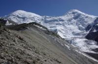
Glaciers of Rushansky ridge.


Leisure break in Tajikistan.
“Books are the plane, and the train, and the road. They are the destination, and the journey. They are home”
Anna Quindlen,
Recreational center in Pamir mountains.
The Rushansky ridge is located in the territories of two regions of the Gorno-Badkhshan Autonomous Region - Ishkashim and Roshtkalinsky. The length of the ridge is 120 kilometers, has an average height of 5100 meters above sea level, the highest point is Pathur peak at a height of 6080 meters above sea level.
The northern slope of the ridge is wide, dissected by deep valleys of tributaries of the Bartang River. The southern slope is short, abruptly breaks off to the Gunt river valley. In the watershed part, the relief is gentle, divided by wide valleys, the upper reaches of which are still occupied by glaciers.
There are 737 glaciers on the Rushansky ridge covering an area of 653.8 square kilometers. The most significant glaciation is in the area of peaks. Pathur and Safedob, where large masses of snow accumulate on large flat surfaces that feed large glaciers.
To the west and east of this site, the size of glaciers is decreasing. The height of the firn line increases from 4400 - 4600 meters above sea level in the western part to 4700 - 4900 meters above sea level in the eastern.
On the northern slope of the Rushan Range 474 glaciers covering an area of 450.2 square kilometers. More than half of this area is located in the basins of the three large tributaries of the Bartang River - the Bardara, Devleh and Raumiddara rivers.
The largest glaciers lie in the axial part of the ridge, in the upper valleys. They have extensive firn basins and wide short sections devoid of moraine cover. Valley glaciers located in deep lateral valleys on the slopes of spurs have long narrow glaciers with buried ends, often creeping to the bottom of the main valley.
In general, on the northern slope, glaciers of valleys make up about a third of all glaciers, and their area is 79% of the total. There are 263 glaciers on the southern slope of the Rushansky ridge, their area is 203.6 square kilometers.
Both in number (60%) and in area (85%), valley glaciers prevail. In 1946, in the headwaters of the Pathur River was the Markovsky Glacier with an area of about 60 square kilometers. 13 large streams merged at the bottom of a vast bowl-shaped basin, forming short moraine ice (Abalakov. 1948).
Currently, this glacier has broken up into several glaciers. The largest of them - the Shteklzar dendritic glacier - has an area of 18.3 square kilometers.
Glaciation of the Rushan Range is represented by glaciers, the total area of which is over 500 square kilometers.
The largest glaciers of the Rushan Range.
The Ouar Glacier, with a length of 9.2 kilometers, an area of 18.3 square kilometers, located at an altitude of 4620 to 5500 meters above sea level, belongs to the Bartang river basin.
The Safedob Glacier, with a length of 12.2 kilometers, an area of 19.4 square kilometers, located at an altitude of 4270 to 5500 meters above sea level, belongs to the Safet-Obdara river basin.
The Shteklazar Glacier, with a length of 10.9 kilometers, an area of 18.9 square kilometers, located at an altitude of 4200 to 5500 meters above sea level, belongs to the Pathor River Basin.
Glacier 830, with a length of 7.9 kilometers, an area of 12.3 square kilometers, located at an altitude of 3900 to 5500 meters above sea level, belongs to the basin of the Vizdara River.
Glacier 603, with a length of 7.8 kilometers, an area of 5.7 square kilometers, located at an altitude of 3740 to 5800 meters above sea level, belongs to the Nukbist River Basin.
The Udarif Glacier, with a length of 7.5 kilometers, an area of 13.6 square kilometers, is located at an altitude of 4060 to 5600 meters above sea level, belongs to the basin of the Rumidara River.
Glacier 674, with a length of 7.5 kilometers, an area of 6.1 square kilometers, located at an altitude of 4100 to 5600 meters above sea level, belongs to the basin of the Turshedavi River.
The Marsor Glacier, with a length of 7.1 kilometers, an area of 8.8 square kilometers, is located at an altitude of 3900 to 5600 meters above sea level, belongs to the basin of the tributary of the Devloch River.
Glacier 734, with a length of 6.8 kilometers, an area of 11.5 square kilometers, located at an altitude of 3880 to 6080 meters above sea level, belongs to the Heydar River Basin.
Glacier 717, with a length of 6.2 kilometers, an area of 7.7 square kilometers, located at an altitude of 4300 to 5400 meters above sea level, belongs to the basin of a tributary of the Devloch River.
Glacier 104 - 106, with a length of 6.0 kilometers, an area of 7.6 square kilometers, located at an altitude of 4460 to 5400 meters above sea level, belongs to the Shazuddara river basin.
Glacier 32, with a length of 5.9 kilometers, an area of 9.5 square kilometers, located at an altitude of 4380 to 5620 meters above sea level, belongs to the Bizang river basin.
Glacier 722, with a length of 5.9 kilometers, an area of 7.9 square kilometers, located at an altitude of 4260 to 5550 meters above sea level, belongs to the basin of the tributary of the Devloch River.
Glacier 144 - 145, with a length of 5.6 kilometers, an area of 4.9 square kilometers, located at an altitude of 4400 to 5500 meters above sea level, belongs to the basin of the tributary of the Safet-Obdara River.
Glacier 84, with a length of 5.3 kilometers, an area of 3.0 square kilometers, located at an altitude of 3540 to 5220 meters above sea level, belongs to the basin of the tributary of the Raumidara River.
Glacier 6, with a length of 5.2 kilometers, an area of 5.5 square kilometers, located at an altitude of 4220 to 5700 meters above sea level, belongs to the Vovzit river basin.
The Chapdara Glacier, with a length of 5.0 kilometers, an area of 8.0 square kilometers, located at an altitude of 4380 to 5350 meters above sea level, belongs to the Chapdara River Basin.
Authority:
"Glaciers." L.D. Dolgushin, G.B. Osipova. Series "Nature of the world." Moscow, the publishing house "Thought". 1989.


