


![]()
You are here
Irgiz-Turgay reserve.
Ecological tours on Western Kazakhstan.
“How many birds! In any lakeside pond
Touch sedge and the swan will go high.
You jump - you look like a deflated falcon is manual
From under a cloud of a swan beats on the fly
Come back girl - shout:
“Wait, show me what you got, young, single!”
Abay Kunanbayev "Spring". Translation by L, Shubin.
Nature of Western Kazakhstan.
The Irgiz-Turgai State Natural Reserve is located at an altitude of 50 to 239 meters above sea level, is located on the territory of the Irgiz district in the westernmost part of the Aktobe region.
The Irgiz-Turgai reserve was established in 2007 on the territory of the Irgiz region with an area of 763,549 hectares.
The reserve was created with the aim of preserving and restoring natural complexes, protecting habitats (wintering, summering, lambing), migration routes of the saiga, a representative of the Betpakdala population; preservation of the unique wetlands of the Irgiz-Turgai lake system, as one of the places of the highest concentration of water birds during the period of seasonal migrations and molting; nesting of flamingos, waterfowl and near-water birds, fish spawning grounds.
According to the physiographic zoning of Kazakhstan, the territory of the reserve belongs to the plains of Kazakhstan and is located within the semi-desert and desert landscape zone of the temperate zone of the Caspian-Turan country.
Most of the territory belongs to the Turgai-Central Kazakhstan region, Nizhne-Turgai province, West Turgai district, Irgiz-Ulkayak and Turgai districts. The smaller southern part of the territory is included in the Aral-Syrdarya region, the North Aral province, the North-Eastern Aral district, the Aral Karakum region.
Geologically, the Irgiz-Turgay Reserve belongs to the Turan Plate and is composed of two sharply different rock complexes: dislocated Precambrian and Paleozoic rocks that form the basement, and almost horizontal Mesozoic-Cenozoic sediments that form a platform cover.
The surface is composed of Quaternary and continental Neogene-Paleogene sandy-clayey formations of different genesis. Quaternary deposits are widespread and are represented by alluvial, lacustrine, lacustrine-alluvial, eolian deposits: inequigranular sands, gravel, pebbles, sandy loams, loams, clays, and siltstones.
According to geomorphological zoning, the territory of the reserve belongs to the Turgai structural-denudation table plain, which is characterized by an interfluve plain. Absolute marks fluctuate on average from 100 to 130 meters, and in the lower reaches of the Torgai River they drop to 80 - 90 meters.
Relief depressions abound in closed lake basins, elongated in a chain in the meridional direction - traces of ancient runoff hollows. On the plain, separate table and remnant forms are often found. Accumulative plains are more widespread, represented by terraces above the floodplain of the Torgai River and its tributaries.
The areas of denudation plains are confined to the valley of the Ulkayak River. In the northeastern part of the reserve, a large remnant ridge stretches in the sublatitudinal direction - the mountains of Shalkarnur, with a length of about 150 kilometers. The highest is its southern part with absolute heights from 190 to 230 meters.
From the west, the ridge is limited by erosion ledges up to 30 - 50 meters high. In the south, the mountains descend by sheer cliffs 120 - 140 meters high to the saline depression of Shalkarteniz. The Shalkarteniz depression is the place where the Torgai River and numerous dry and drying riverbeds drain.
The plain between the Torgai River and the Shalkarnur Mountains is a hilly surface with many drainless flat-bottomed basins, sloping towards the river valley. The hills are elongated to the east and northeast. The tops of the hills are flat, table-like or domed.
The bottoms of the basins are occupied by swampy meadow vegetation, reeds or solonchaks and takyrs. In the west of the plain, along the Torgai River, there are small massifs of hummocky sands, covered with semi-shrub and herbaceous vegetation.
Climate of Irgiz-Torgai reserve is sharply continental, with a low amount of precipitation (about 200 mm), an abundance of solar radiation, high dryness and intensity of evaporation processes, and significant fluctuations in seasonal and daily temperatures.
Summer is moderately hot, mostly with clear weather. The prevailing temperature in July during the day is 25 - 30 C, at night 12 - 18 C. The absolute maximum can reach 43 - 44 C. The winter is cold, long, with an average January temperature of 17 C.
In severe winters, temperatures can drop to 43-45 C. The maximum snow depth is 42-44 cm. In winter, northeasterly winds prevail. The average annual wind speed is 3.8 - 5.1 m/s. Strong winds with a speed of 15 m/s or more, occurring in autumn and winter, cause snowstorms and snowstorms; accompanied by dust storms in summer.
Comfortable climatic conditions are formed in the transitional seasons: April-May, September-October, the total duration of which increases from north to south from 43 - 48 to 60 - 64 days. These periods are favorable for rest. In terms of microclimate, the most favorable are areas near rivers and lakes.
Hydrographic network of the Irgiz-Turgai reserve is represented by the Torgai and Olkeyek rivers. The rivers flow mainly along the Turgai hollow, overflowing into branches, forming many lakes and oxbow lakes. According to the basin affiliation, the lakes are divided into two systems:
1 - Torgai rivers (Kogakol, Zharkamys, Keltekol, Renkol, etc.)
2 - Olkeyek (Alakol, Alabugykol, Eginkol, Sarykamys, etc.).
Rivers and lakes freeze in mid-November, open in the first ten days of April, the thickness of ice in the reaches reaches 1 meter, and the shallowest of them freeze through. The spring flood on the rivers lasts about a week. Water at this time floods the low places of the valleys and the lakes and oxbow lakes located there.
Underground waters of Irgiz-Turgai reserve belong to the Aral-Turgai hydrogeological region and are in conditions of constant moisture deficit, low water exchange and high evaporation, which leads to the formation of waters of increased mineralization.
Predominantly brackish and saline underground waters with salinity from 3 - 5 to 10 - 15 g/l are widespread. The alluvial Quaternary deposits filling the river valleys contain brackish waters with salinity up to 3 g/l and more.
Of practical interest are the underground waters of large sandy massifs composed of eolian deposits. The thickness of the water-bearing deposits is from 4 to 20 m, the average is 10-13 m. The flow rates of wells vary from 0.5 to 4.5 l/s. Fresh waters with a mineralization of 0.1 - 0.6 g / l, the composition is hydrocarbonate-sulfate sodium.
Soil cover of the Irgiz-Turgai reserve. The territory is located in the subzone of brown soils. A feature of the soil cover is strong salinity, predominantly light mechanical composition and the wide distribution of hydromorphic soils, solonchaks and solonetzes.
Brown normal and brown solonetzic soils of predominantly light loamy and sandy texture and their complexes with desert solonetzes are widespread. In river valleys - meadow and alluvial-meadow soils, often in combination with solonetzes and solonchaks, meadow brown solonetsous soils with the presence of solonchak solonetzes or solonchaks.
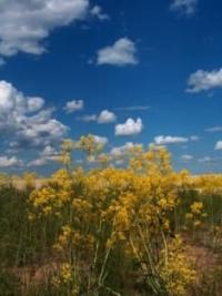
Vegetation cover of Irgiz-Turgai reserve. Botanically and geographically, the territory is part of the West Kazakhstan steppe province, the Mugodzhar-Turgay subprovince, the subzone of real steppes of the Turgay floristic region.
Erkekovo-green wormwood steppes on sandy soils, Erkekovo-white wormwood deserts on clay-sandy soils and ephemeral-white wormwood deserts are common here. On overgrown loose-sandy soils, well permeable to moisture, sod-cereal vegetation of the steppe type is formed with the inclusion of green wormwood.
On more connected sandy soils, the vegetation approaches the zonal desert: first erkekovo-white wormwood, then ephemeral-white wormwood (bulbous bluegrass, white earth wormwood). On loose ancient eolian sands, steppe associations grow with the participation of fescue, feather grass, erkek and wormwood. In the valleys of the Torgai and Olkeyek rivers, plant complexes are represented by ephemeral, erkek wormwoods and green wormwoods.
The flora is represented by 430 species from 64 families and 216 genera: the largest families of Asteraceae (64 species) are yarrow tansy, Austrian wormwood, dissected cousinia, saline sosurea, etc.; haze (29 species), sedge (24 species).
Of the coastal aquatic vegetation, reeds, reeds, cattails, tubers of reeds, susak, chastuha, arrowhead, water buttercup, burr, horsetail, water moss were noted; from real aquatic plants - water lilies, duckweed, pondweed, uruti, naiads, pemphigus, hornwort, 9 species of charophytes and 42 species of varieties and forms of dominant microalgae.
Fauna of Irgiz-Turgay Reserve. According to the zoogeographic zoning of Kazakhstan, the territory of the reserve belongs to the Central Asian subregion, the Kazakh-Mongolian province, the Kazakh district, a section of the western part of the semi-desert zone.
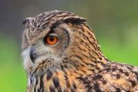
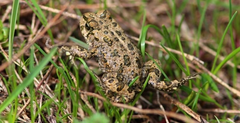
On the territory of the reserve there are 29 species of mammals, 250 species of birds, 14 species of reptiles, 4 species of amphibians and 10 species of fish. The ichthyofauna is represented by ten species: carp, silver and gold carp, ide, roach, bream, tench, perch, ruff, pike.
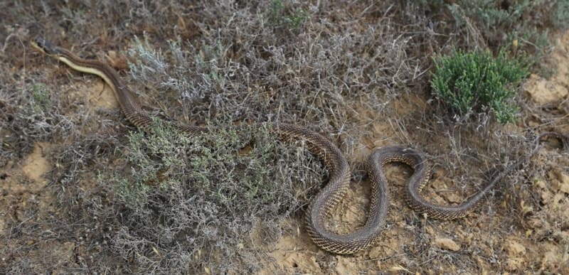
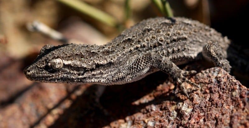
Aral carp, tench, bream are imported and acclimatized species. Amphibians are represented by common spadefoot, green toad, lake frog and moor frog. Reptiles - marsh and Central Asian turtles, squeaky gecko, crested gecko, takyr round-headed, round-tailed round-headed, eared round-headed, nimble, fast and multi-colored foot and mouth disease, patterned snake, arrow-snake, steppe viper, water snake. Birds are represented mainly by representatives of the wetland complex, numbering 109 species.
During the period of seasonal migrations and molting, at least 2 - 3 million birds of waterfowl and semiaquatic species fly here. Passerines (90 species) are widely represented, mainly forest pipit, garden and gray warblers, gray and small flycatchers, wheatears (common, dancer, pleshanka, desert).
In thickets of bushes there is a gall bunting and a gray shrike. Birds of prey prefer open landscapes: steppe harrier, steppe and common kestrel, golden eagle, imperial eagle, steppe eagle and others, 30 species in total.
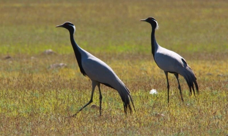
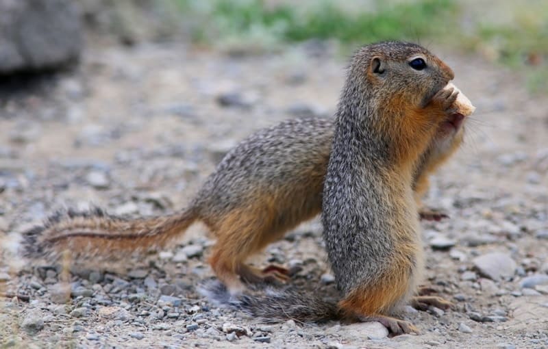
There are 32 rare and endangered species of birds listed in the Red Book of Kazakhstan: pink and curly pelicans, spoonbill, loaf, little white heron, flamingo, lesser swan, whooper swan, red-throated goose, white-headed geese, Siberian crane, gray crane, demoiselle crane , bustard, jack, little bustard, lapwing, slender-billed curlew, black-headed gull, black-bellied and white-bellied grouse, saja, peregrine falcon, saker falcon, white-tailed and long-tailed eagles, golden eagle, imperial eagle, steppe eagle, short-toed eagle, osprey, common vole, sandstone ground squirrel, steppe mouse , pika, on clay plains - thick-tailed jerboa, on takyrs and solonchaks - tarbagan, on light soils - yellow ground squirrel and emaranchik; in reed and cattail thickets in shallow areas along the banks of rivers and lakes, there are water voles, muskrats, and wild boars.
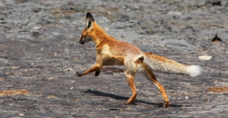
Of the predators in open spaces, the corsac fox, the steppe polecat live, the fox is ubiquitous, and in some places the wolf. The southern part of the reserve is inhabited by the saiga, a representative of the Betpakdala population, which in the past was the largest in Kazakhstan in terms of range and abundance.
The main places for wintering, lambing and summering are the plain between the Torgai River and the Shalkarnur Mountains. Of the rare species included in the Red Book, there are Bobrinsky leather, endemic to Kazakhstan and sand cat, a rare rare species in the fauna of Kazakhstan.
The nature reserve consists of two regional branches - northern and southern, which are separated by the Turgai State Natural Reserve (zoological). The northern regional branch, with an area of 89,040 ha, includes the lakes of the Olkeyek group and the valley of the Olkeyek river.
The southern regional branch, with an area of 674,509 ha, includes wetlands of international importance, a system of lakes on the Torgai river, the Shalkarteniz flat depression, the Shalkarnura mountains, Kurdym, Karakol and Bakshakol lakes, located in the lower reaches of the Torgai river.
Protected objects are located on the territory of the reserve: wetlands of international importance with well-preserved natural landscapes; places of the highest concentration of water birds during the period of seasonal migrations and molting; a group of lakes on the Olkeyek River, where a large number of waterfowl and semiaquatic birds live on migration and spawning grounds for commercial fish are concentrated; habitats, wintering, summering and lambing of the Betpakdala saiga population; saxaul massifs in the flat areas of the Shalkarteniz depression; lakes Kurdym, Kulykol, included in the List of objects of the state nature reserve fund of republican significance and approved by the Decree of the Government of the Republic of Kazakhstan dated September 28, 2006 No.
932 - as unique natural water bodies, habitats and nesting places for waterfowl and semiaquatic birds, spawning grounds for commercial fish ; chinks of Shalkarnura, included in the List of objects of the state natural reserve fund of republican significance, approved by the Decree of the Government of the Republic of Kazakhstan dated September 28, 2006 No. 932, as a geomorphological object for studying the geological development of the territory; habitats of birds listed in the Red Book - pink and curly pelican, spoonbill, loaf, little white heron, flamingo, lesser swan, whooper swan, red-breasted goose, white-headed goose, Siberian crane, gray crane, demoiselle crane, bustard, little bustard, jack , gyrfalcon, slender-billed curlew, black-headed gull, black-bellied and white-bellied sandgrouse, saji, peregrine falcon, balob reserved and ordered. Any activity that disrupts the natural state of ecosystems is prohibited. To ensure the protection and protection of especially valuable natural complexes of the reserve from possible adverse factors and to preserve the ecological integrity of natural complexes around the reserve, a buffer zone with a width of at least 2 km has been created around the entire perimeter. Within the buffer zone, any activity that adversely affects the state and restoration of the ecological systems of the reserve and the objects of the natural reserve fund located on them is limited.
Geographical coordinates of Irgiz-Torgai Reserve: N48°22'32.01" E62°45'50.99"


Authority:
"The ecological project» Natural resources of the Aktyubinsk area.
http://aktobe.su
Photos by
Alexander Petrov.