You are here
Jety-Oguz Wall Peak.

Ascent to Jety-Oguz Wall Peak.
"Before Jety-uguz there was the same monotonous view of the grassy treeless low hills at the foot of Terskey-Ala-tau; to the right one could see in the distance the extremities of the Kizil-kiya Mountains descending towards Issyk-kul, and behind them the Kungey-Ala-tau turned blue; at Jety-uguz, up its gorge, a beautiful view opened up of the snowy conical Uguz-bash, the shape of which P.P. Semenov compares with the Wetterhorn in the Alps. Judging by the upper boundary of the firs, which does not reach even half its height, this is a peak of 16,000 - 17,000 feet, like most of the peaks of this range.
"Travel to Turkestan Region and Exploration of Mountainous Country of Tien-Shan." N. Severtsov. 1873.
Ascents in Jety-Oguz Gorge.
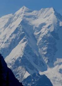
Jety-Oguz Wall, a rock and ice peak 5,180 meters above sea level, is located on northern slope of Terskey Ala-Too Range, in upper reaches of Ailanysh River, in Jety-Oguz District in east of Issyk-Kul Region. The Jety-Oguz Wall impresses with its beauty thanks to the hanging glaciers that adorn its slopes.
The routes on the wall are among the most difficult – 5 – 6 categories. In the area of the northwestern Jety-Oguz Glacier and the ridge dividing the basins of the Ailanysh River and the Baytor Gorge, there is an outstanding double peak 5,170 meters high - Oguz-Bashi, which means "Bull's Head".
This mountain attracted attention back in 1856, when the traveler Semenov-Tyan-Shansky compared it to the graceful peak of Jungfrau in the Swiss Alps. On the watershed with the Karakol gorge is the sharp Zhukov peak, the height of which reaches 4250 meters.
Many of these peaks were conquered only once, as part of the ice class at the Union Championships, which emphasizes their complexity and uniqueness. From the "Flower Glade", located in the central part of the Jety-Oguz gorge, there is an excellent view of the two-headed Jety-Oguz wall. The distance to it from here is about 17 - 18 kilometers.
History of first ascent of Jety-Oguz Wall peak.
The first ascent of the Jety-Oguz Wall was made in 1958 by four climbers led by V. N. Naryshkin along the northwestern glacier of the Jety-Oguz and the northwestern ridge (the watershed between the Ailanysh River and the Baytor Gorge).
In August 2013, the passage of one of the sections of the Jety-Oguz Wall by members of the Novosibirsk State University hiking club, Novosibirsk.
Route: in the main ridge of Terskey Ala Too between the peaks of Karakol 5281 meters above sea level and Oguz-Bashi 5163 meters above sea level, in the lowest point of the Jety-Oguz Wall. Leads from the Ailanysh Glacier in the north to the upper plateau of the ridge, then south to the Kiche-Bordu Glacier, connecting the basins of the Jety-Oguz and Sarychat Rivers.
Expedition members: Sergey Mironov - leader, Alexander Selyutin, Nikolay Smolentsev, Artem Smolentsev, Ivan Kudashov, Konstantin Starostin, Alexey Vorobyov, Nikolay Balkovoy, Georgy Salnikov.
Geographic coordinates of Jety-Oguz Wall massif: N42°09'37 E78°25'04


Authority:
Alexander Petrov.
https://risk.ru/blog/217842
Photos by:
Sergei Pyshnenko, Bishkek city.
http://karakol.kg


