


![]()
You are here
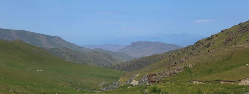
Karzhantau Ridge.

Mountain ranges in Kazakhstan.
“Karzhantau Ridge, stretching from northeast to southwest, is in a more advantageous position to intercept humid air currents from the Atlantic and receives much more precipitation at the same altitude than the Talas Alatau. Because of this, subalpine and alpine forb meadows occupy a relatively large area in Karzhantau, while in the reserve … they are found at much higher altitudes. High-mountain fescue steppes are widespread in the reserve, while in Karzhantau they are almost never found, since there are very few cereals in the upper belt of these mountains. The Karzhantau ridge is flattened everywhere, hilly, devoid of lifeless sharp peaks, screes and glaciers, while in the reserve, on the contrary, these relief elements occupy a fairly large area. In Karzhantau, cattle are grazed very intensively every year, and as a result, the meadows here are very low-grass and relatively poor in cereals. The belt of shrubs, including creeping juniper, is poorly expressed in these mountains, and alien plants are widespread (bird buckwheat, creeping and meadow clover, dandelion, thistle, thistle, etc.), sometimes forming entire communities and enriching the food supply of animals. In the reserve, on the contrary, cattle are hardly grazed, so the meadows are high-grass, abundant in cereals, which create a lot of dead rags in the fall; the belt of creeping juniper is well expressed and the shrubs rise to great heights. And, finally, marmots are common in Karzhantau."
Vadim Ivanovich Kapitonov. 1969.
Walk in Karzhantau Ridge.
Karzhantau Range (Kazakh: Қаржантау жотсы, Uzbek: Qorjontov/Қоржонтов) is 103 kilometers long and is most southwestern range of Western Tien-Shan mountain system. It is located in Turkestan region of Republic of Kazakhstan and Tashkent region of Republic of Uzbekistan.
Karzhantau is a mountain range in the Western Tien Shan mountain system. Most of the range is located in the Turkestan region of Kazakhstan, only in the southwest for 16 kilometers the range enters the territory of the Tashkent region of Uzbekistan. The mountain range stretches from southwest to northeast.
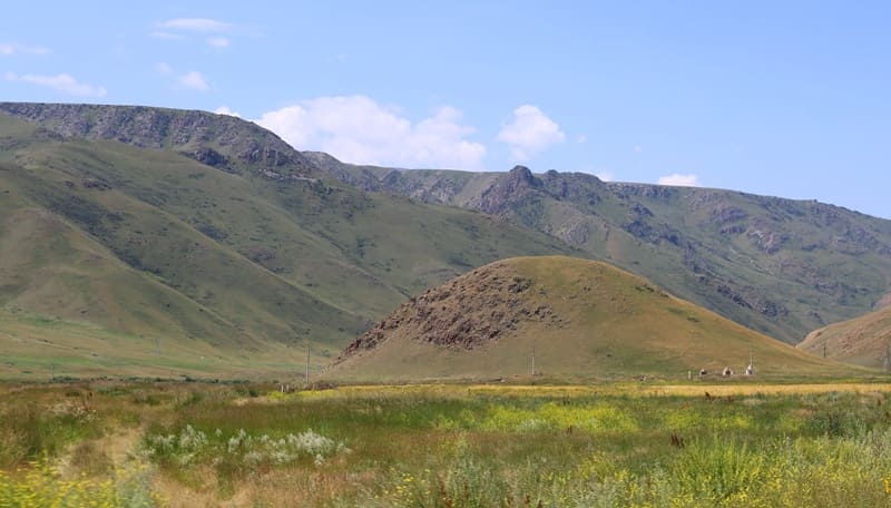
Geomorphology of Karzhantau Range.
Average heights in the central part are 2000 meters, in the southwest - 700-800 meters above sea level. Individual peaks reach 2500-2800 meters above sea level. The highest point of the Karzhantau ridge is Mount Mingbulak, 2823.8 meters above sea level, which is a border point; the state border between the two countries passes through its peak.
Descending to the southwest, the ridge turns into the Karachatau Upland. Here, a section of the state border between Kazakhstan and Uzbekistan is drawn along the ridge for 17 kilometers. It continues in the northeast direction, abutting the middle part of the Ugam ridge. In the north, Karzhantau stretches almost in the latitudinal direction.
Geology of Karzhantau ridge.
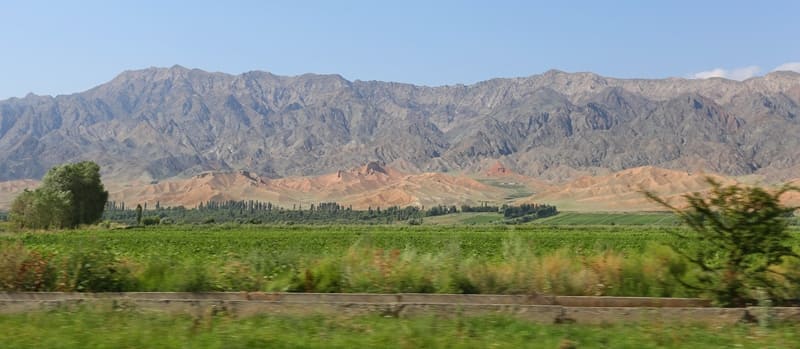
Karzhantau ridge is formed mainly by Paleozoic igneous rocks, sandstone, clay shales, and conglomerates. In some places, the mountains are composed of Carboniferous and Devonian limestones and dolomites, which create conditions for karst relief.
There are karrs, karst sinkholes, karst mines and karst caves. The Karzhantau uplift is an anticlinal structure. As an orographic unit, Karzhantau appeared in the post-Oligocene period. The ridge has an asymmetric structure. From the southeast, Karzhantau forms very steep, sheer lateral slopes, which are deeply cut by deep gorges.
Karzhantau borders the Ugam River valley in the west. The northwestern slopes are gentle. They are cut by the left tributaries of the Keles River. The ridge has a strongly eroded, flattened ridge at an altitude of about 2000 meters above sea level.
Its northwestern slopes, facing Shymkent, are gentle and form a series of steps, and the southeastern ones are steep and inaccessible; the southwestern end of the ridge is a flat plateau-like surface at an altitude of 600-700 meters above sea level.
Hydrography of Karzhantau ridge.
Karzhantau acts as a watershed between the Ugam and Chirchik basins on one side, and the Keles basin on the other. Among the rivers of the Keles basin, the Kyzylatasai, Zhuzumsay, Uyasay, Karzhansai, Kokparsay, Mugalysay, as well as the Badam River (a tributary of the Arys) flow down from the northwestern slope of the ridge.
The rivers of the Chirchik basin flow to the east: Orkutsay, Kyzylsu, Aktashsay, Tavaksay, Azadbashsay.
Flora of Karzhantau Ridge.
Vegetation on the slopes is represented by forb-wheatgrass steppes, above which lie high-mountain meadows. In the deep valleys cutting through the lateral slopes, there are spruce forests, and up to an altitude of 1400 - 2000 meters above sea level - gardens and walnut forests.
Flora in the highlands of the Karzhantau Ridge, from 2500 meters above sea level, growing along watersheds and adjacent areas of the slopes, is of great importance for the development of livestock farming in the Tashkent region (along with the high-mountain vegetation of several other ridges).
Economic importance of Karzhantau Ridge.
Secondary quartzites have been discovered in Karzhantau. Near the southwestern end of the ridge, 3 - 4 kilometers north of the settlement of Sailyk, there is a complex Aktash deposit (corundum-diaspore-alunite-agalmatolite). M.E. Masson indicates that agalmatolite (kalybtash) mining at the Aktash deposit was already underway in the XVIth century.
On the territory of Kazakhstan, the Karzhantau ridge is part of the Sairam-Ugam National Park.
Geographical coordinates of Karzhantau ridge: N41°47'53 E69°55'04
Authority:
https://strannik.fst.kg/ugamskij-xrebet/
Semyonova M.I. "Nature and Economy of South Kazakhstan Region". Alma-Ata. Publishing House of Academy of Sciences. 1959.
"From Tien-Shan to Altai". A.F. Kovshar. Almaty. 2024.
Photos by:
Alexander Petrov.