


![]()
You are here
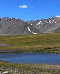
Lake Dzhukuchak.
Hiking routes along lakes in Terskey Ala-Too mountains.
"Syrts (morainic depression) is an endless, dreary, hilly plain, in places covered with dense grassy vegetation, in places completely devoid of it, cut in a variety of directions by streams, rivers, lakes, swamps without any woody vegetation, devoid of any housing, extremely poor in bird population, bordered on both sides by giant mountain ranges covered with eternal snow and ice, in the north by Terskey Alatau, in the south by Ak-Shiyryak."
L.K. Davydov "Petrov Glacier", 1925.
Tours along high-mountain valley of Arabel in Kyrgyzstan.
Flowing, fresh, moraine lake Dzhukuchak is located at an altitude of 3766.3 meters above sea level, is located on southern slope of Terskey Ala-Too ridge and between northwestern spurs of Ak-Shyirak ridge, in upper reaches of Kumtor River, 6.7 kilometers southeast of Dzhukuchak pass at an altitude of 4042 meters above sea level, 9.3 kilometers northwest of glacial lake Petrov located at an altitude of 3730 meters above sea level in Jety-Oguz district of Issyk-Kul region.
The Dzhukuchak South River, 7 kilometers long, flows into Lake Dzhukuchak from the north, and is the main filling for the lake. The lake consists of two parts and is connected by a 286-meter isthmus. The main part of the lake is located south of the upper part of the lake.
The length of the lake is 2.3 kilometers, the greatest width of the upper part of the lake reaches 782 meters, the greatest width of the lower part of the lake is 1.4 kilometers, the area of the lake is 1.28 square kilometers, the length of the coastline reaches 7.28 kilometers.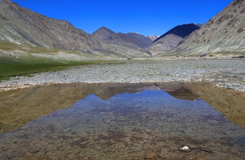
From the western part of the lower, large lake flows the Kumtor River, which after 7.6 kilometers reaches the tailings of the Kumtor mine. The Dzhukuchak South River originates from a small glacier located on the southern slope of the pass of the same name.
The high-mountain lake Dzhukuchak, located on the southern slope of the Terskey Ala-Too ridge, is one of the most picturesque and little-studied reservoirs of the Tien-Shan. This lake, lost among the hills and high-mountain syrts of the eastern part of the Arabel Valley, among the rocky peaks attracts with its pristine beauty and an atmosphere of solitude.
The lake was formed as a result of the damming of the river valley with moraine deposits. The water has a rich turquoise hue, typical of high-mountain glacial lakes. The reservoir is practically devoid of vegetation due to low water temperatures; alpine meadows with typical high-mountain flora are found in the vicinity of the lake.
Tourist routes to the south lead to the lake when descending from the Dzhukuchak Pass. The lake is rarely visited by tourists, which preserves its pristine nature. It should be noted that further descent from the lake and further down the river Kumtor will be difficult due to the location of the "Kumtor" mine on the further route.
Passage through the mine is prohibited. The lake is of interest to:
- Glaciologists studying the dynamics of mountain glaciers
- Climatologists studying changes in high-mountain ecosystems
- Hydrologists monitoring the balance of glacial nutrition
Local residents associate the lake with ancient legends. The name "Dzhukuchak" in translation from Kyrgyz means "small bowl", which reflects its shape, reminiscent of a natural vessel among the mountains. Lake Dzhukuchak is a unique natural object that has preserved its pristine beauty.
Its inaccessibility and harsh conditions create a special atmosphere that attracts true connoisseurs of mountain nature. Preservation of this pearl of Terskey Ala-Too is an important task for future generations.
Geographic coordinates of Lake Dzhukuchak: N41°57'35 E78°08'47
Authority and photos by:
Alexander Petrov.