


![]()
You are here
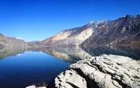
Lake of Sarez.

Relaxed traveller Pamir in Tajikistan.
“Travel is fatal to prejudice, bigotry, and narrow-mindedness, and many of our people need it sorely on these accounts. Broad, wholesome, charitable views of men and things cannot be acquired by vegetating in one little corner of the earth all one's lifetime”
Mark Twain.
Outdoor enthusiast in Tajikistan.
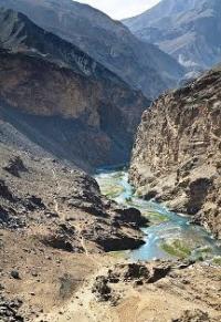
The Lake Sarez location in Gorno-Badakhshan Autonomous Oblast. In February 1911 an earthquake in the centre of the Pamirs, registering 9 on the Richter scale, caused a vast landslide which blocked the Murghab River.
A huge part of the Muzkol slope collapsed and buried the peacefully sleeping Usoy village. Around 90 inhabitants of the village were killed, probably never having realized what had happened. The ob struction in the river caused a lake to form.
This reservoir then started accumulating river water which, one year after the catastrophe, flooded Sarez village. The lake was named Sarez. It is located at an altitude of 3,000m, is almost 55 km long, on average 1.5k m wide (maximum width 3.3 km). with a maximum depth of about 500m and covers about 80 kml.
The temperature of the water is 4 - 6°C. The height of the Usoy dam from the bottom of the lake is about 570 m, with an average height of about 67 m above the water. It is about 5 km long, has an average width of 3.2 km, and weighs something like 6 billion tons.
There is about 17 km3 of fresh water in the lake. Small streams filter underneath the Usoy dam and form a river as they join together. After several kilometres it joins the Kudara River, after which it is called the Bartang River, which flows into the Panj River.
Lake Sarez has an area of 79.7 square kilometers, a length of 56 kilometers, an average width of 1.44 kilometers and a maximum width of 3.3 kilometers. The maximum depth is 500 meters! It is the deepest freshwater reservoir in Central Asia and Kazakhstan.
In the center of the Pamirs, accumulated more than 16 cubic kilometers - fresh water. The average depth of Lake Sarez is 202 meters, the length of the coast is 162 kilometers, the fluctuation of the water level in the lake during the year is about 12 meters, the maximum is 22 meters, this is the height of an eight-story building!
The lake level continues to grow in our time, at about 18 centimeters per year. However, up to the lowest part of the crest of the dam is still about forty meters. Moreover, as a result of global warming, the glaciation in the origins of Murghab is reduced. For 35 years, from 1949 to 1984, it decreased by 37%, or 87 cubic kilometers of ice.
The climate on the shores of Lake Sarez is dry, in summer the temperature can rise to plus thirty, in winter it drops to minus thirty, the frost-free period is only 100 days a year. There is little rainfall - a little over a hundred millimeters: it is difficult for the clouds to break through here through high ridges.
The lake freezes in early November, the ice melts in May. The thickness of the ice is usually a little more than half a meter, in frosty winters - up to a meter. Landslide-landslide processes continue on the shores of the lake, for example, in August 1987, eleven kilometers above the blockage, a collapse of 18 million cubic meters fell from the right bank, lifting waves up to 15 meters high on the lake.
From Sarez to Panj the Bartang flows along the narrow crack of a stone valley. It flows roughly and fast, carrying millions of tons of sand, mud and anything else that can be carried. The depth of the valley in some places reaches one and half kilometres.
Stone scree cover the valley's slopes.The formation of the lake brought with it several problems. The main one is the possibility of the Usoy dam breaking or the lake spilling over. If that were to happen, billons of tons of water could wash everything out of the way below the dam - not only along Bartang but also Panj and Amu Darya valleys as well.
To prevent such a possible catastrophe, the idea was suggested of discharging water in the lake and us "c it for irrigation or power production in Central Asia. Others think that the Usoy dam is a natural, stable formation and there is no reason to fear its collapse.
Numerous specialized expeditions were organized during the Soviet period to study the problem. Ir the 1950s an expedition Room the Academy of Sciences 3 the USSR visited the lake to look for the legendary Yeti.
Various hypotheses and scenarios, both optimistic and pessimistic, were made as a result of research and various projects developed. However, the specialists could not come to a consensus on the issue. Taking into account the contradictory results of research, the Tajik government appealed to the world community with a request for assistance in solving the Lake Sarez problem.
Since 2000 an international Lake Sarez risk mitigation project has been implemented. The project envisions setting up monitoring and early-warning systems to minimize the potentially disas-terous consequences if the Usoy dam were to break, and preparing and training the population living in the settlements along Lake Sarez in case of any other emergency situations.
In summer 2004, divers went down into Lake Sarez and investigated parts of the dam. It is possible to reach the lake by a charter helicopter or to go by car to the Barchadiv village in Bartang Valley and then on foot, or from Langar through Langar pass (H-4620), also on foot, to reach the upper Ghunt River, and then to Irkht bay on Lake Sarez.
Visiting the lake via the Bartang Valley requires permission from the Ministry of Emergencies and Civil Defence of Tajikistan. It is more advisable to organize expeditions to the lake via local tourist firms since there is little infrastructure in the area and tourists cannot expect a safe and successful tour if they make the trip alone.
Authorship:
Javad Abed Khorasani. http://www.asraresokhan.com “Born by the earth and sky, or“ Pamir Baikal ”. Alexander Yablokov