


You are here
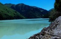
Lake Upper Zhasylkol.
Lakes of Dzhungarskiy Alatau.
“Only the heart is sharp-sighted. You cannot see the most important thing with your eyes."
A. Saint-Exupery.
Walk to lakes Dzhungarskiy Alatau.
The Upper Zhasylkol flowing lake is located at an altitude of 2262 meters above sea level, located on the northern slope of the Dzhungarsky Alatau ridge in the Kinozen river valley, 14.1 kilometers (in a straight line) from the Lower Zhasylkol lake in the Zhongar-Alatau natural park in the Alakol district of the Almaty region.
From the north, the Kinozen River flows into Lake Verkhny Zhasylkol, which receives tributaries from the Kyzylauz rivers, an eastern tributary, and Taldy, a western tributary. The Taldy river basin is formed from the Koshachii Glaz glaciers located at an altitude of 3808 meters above sea level, Zenkov, Arkhipov West, Avsyuk and the Novosibirsk University glacier located at an altitude of 4260 meters above sea level.
The Kyzylauz River is formed from the Shumsky glaciers located at an altitude of 4115 meters above sea level (not to be confused with the Shumsky glaciers in the Malyi Baskan river basin), Dalniy I (Semenov Tyan-Shansky) located at 4280 meters above sea level and the Lepsinsky glacier.
The greatest length of Lake Upper Zhasylkol from the southeast to the north is 3.3 kilometers, the greatest width in the central part of the lake is 631 meters.
Geographic coordinates of the Upper Zhasylkol lake: N45 ° 15'41.31 "E80 ° 37'34.70"
Authority and photos:
Alexander Petrov.