


![]()
You are here
Sights Talgar gorge.


Hiking to Talgar gorge.
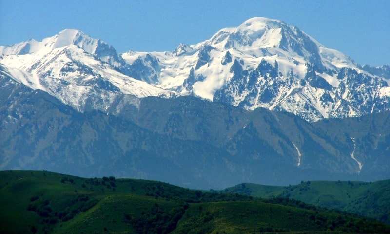
“In general, Talgar looks from here, from the south, completely different than from the side of Ili. There, in the north, Talgar seemed to us a corner of a gigantic fortress and, enlivened by vegetation at the foot, reminded us of summer and warmth, and the small glacier feeding its river was hiding in the head of a deep valley; here, in the south, just the opposite, despite the direct rays of the burning Central Asian sun, the Bogatyr glacier, the largest in the range, embraces it with a cold wide smooth surface from both the south and the east, and, rising above this glacier, Talgar stands like a mountainous island on an icy sea , there is not a single blade of grass and everything speaks of a harsh, eternal winter.»
Sergei Evgenievich Dmitriev (1861 - 1931).
Go rambling Tien-Shan mountains.
Gorge of Talgar River is located at an altitude of 1201.7 m. a. s. l., on northern slope of Zailiysky Alatau ridge in Talgar district of Almaty region.
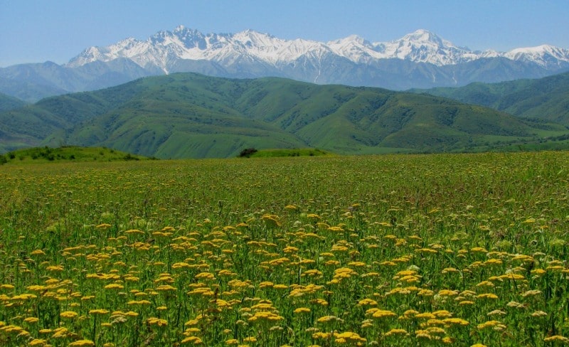
Opposite the city of Talgar in the mountains there are several large gorges: Right, Middle and Left Talgar, Soldier, Stone, Aspen, Maralsay and many gorges. All of them originate in the Talgar mountain junction, located in the center of the glaciation of the Zailiysky Alatau.
The Talgar River and its main tributaries are distinguished by high water, rapid flow and roar of the seething stream. Nowhere in the Northern Tien-Shan is there such a wide belt of "counters", huge hills and large foothill gorges, composed of sedimentary rocks - loess-like loams, gradually turning into a crystalline, mostly granite, massif of the Zailiysky Alatau.
The wild fruit belt is quite wide, occupied by the wild Sivsrs apple tree, apricot, hawthorn, bird cherry, barberry, currant, and raspberry. Willow, Tien-Shan birch with pink bark and small leaves grow in floodplains. In some places, elms (pinnately branched elm) and poplars grow.
But the main background of woody vegetation of the floodplain belongs to the wild apple tree and wild apricot (apricot). In this area, the lower boundary of single fir trees descends to 1250 m above sea level, and the upper one rises to 2950 m.
Here is the widest spruce belt of the Zailiyskiy Alatau. Usually in the Tien Shan in the forest belt, Schrenk spruce grows in the lower parts of the slopes with aspen and birch, and rarely with the Sievers apple tree. In the Talgar gorges, especially in Kamennaya Shchel and Maralsay, at an altitude of 1500 - 1800 m. a. s. l., large areas are occupied by apple and hawthorn spruce forests: among the spruce forests, foresters have planted beautiful apple orchards that yield delicious fruits.
It is simply amazing how relatively heat-loving fruit crops and spruce, accustomed to a cold climate, can live together in the Talgar Gorges? Wild apricot grows mixed with birch, willow, aspen and apple in floodplains and on slightly shaded slopes.
On the slopes of southern exposures, apricot forms pure plantations. Entire slopes occupied by apricots are found only in the Talgar gorges. Apparently, in the mountains of Ileisk Alatau near the city of Talgar, the proximity of large glaciers and the highest peaks created a more humid microclimate.
It is interesting that in these places the apple and apricot trees rise to the mountains up to 2100 m, and the Tien-Shan birch - up to 2300 m. and Scotch pine. The territory of the Alma-Ata Reserve is spread along the middle and left Talgar.
An asphalt road was laid from the city of Talgar in the direction of the reserve to the former Sputnik pioneer camp.
Higher in the mountains there is a dirt mountain road along the floodplain of the Right Talgar River. In the floodplain of the river and along the slopes of the mountains there are many wild fruit thickets of apple, hawthorn, apricot, and raspberry.
Lots of scree and mudslides. From a height of 1650 m on the territory of the reserve, undivided dominance passes to rowan, grass-forb and moss spruce forests on very steep shaded slopes of the northern exposure. The Soldiers' Gorge deserves special attention, starting from the north-eastern outskirts of the city of Talgar.
The paved road leading to the forestry goes through a wide gorge and along the slopes of the "counters" through huge mountain gardens. This gorge has long been mastered. The Talgar lateral ridge, running from the Zailiysky Alatau to the north for 15 - 20 km, is composed of loess-like loams with excellent mountain chernozems, leveled peaks, gentle slopes and wide valleys, has long attracted the attention of gardeners and farmers.
To the west, 3 - 5 km from the Soldiers' Gorge, there are Kamennaya and Aspen cracks, surrounded by gardens with many birch and pine groves created by foresters. Here, gardens grow surrounded by majestic Tien-Shan firs.
No less interesting is the Middle Talgar gorge, the path to which begins at an altitude of 1490 m. a. s. l. from the road to the base of the Almaty Reserve. It is impossible to build a road to this gorge 168 - solid rocks and talus, and below in a deep and steep gorge or in sheer canyons the swift river Sredny Talgar rumbles.
Along the gorge there is a 9.5 km horse trail. The northeastern slope is covered with a dense forest of aspen, apple, hawthorn and aspen-birch spruce forests. The slopes of the northwestern and western exposures are drier and warmer; rare apple-hawthorn and apricot thickets grow on them, which on the middle and upper parts of the slopes turn into rare apricots from single trees.
The upper part of the gorge ends with the famous Talgar mountain junction - with the highest peaks of the Zailiskiy Alatau. In many places, the Middle Talgar gorge is solid rocks, cliffs, cliffs, scree and huge stones, the size of a one-story house.
They have sharp corners and are scattered both in the floodplain and on the slopes. In some places, in low places on shallow soil, apple, aspen and spruce forests grow. Bird cherry, a lot of raspberries, honeysuckle, wild rose and mountain ash are found in the floodplain of the river and near it.
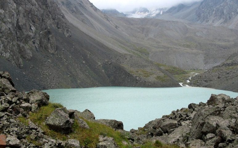
There are juniper pillows on the rocks. But the general picture of the Middle Talgar is the wild beauty of a very steep, steep gorge: solid rocks and cliffs, a turbulent river in a narrow gorge and glaciers and snowy peaks ahead. At an altitude of 2650 m. a. s. l., the ruins of the climbers' camp are located. In the late 70s, a mudflow hit the camp, and since then the camp has ceased to function.
From the top of the mountain, located northwest of the Talgar Peak, from the broken underground lake, a mudflow rushed to the climbers' camp of such force that it tore off part of the houses from the foundations, threw the roofs of the buildings over tens of meters and filled up everything with heaps of stones.
The climbers, having heard the noise, reached the elevated places in advance and were not injured. An unforgettable panorama opens from here. Ahead to the south is the bulk of the Karaulche-Tau peak with several glaciers, to the right of it to the south-west is the glacier from which the Sredny Talgar River originates.
A little to the southeast, only the top of the Talgar Peak is visible. Talgar Peak looks like a dome, near the top of which there is a glacier. Viewed Talgar Peak from the eastern part of the city of Talgar. A complete picture of it and the entire mountain junction around with many glaciers opens up from the main asphalt road Almaty - Shelek (Chilik).
Two huge moraines descended from the Talgar peak and adjacent slopes - ancient glacial and modern, blocking the Middle Talgar gorge. Therefore, the water flowing down from the glaciers of the Talgar Peak flows into the channel of the Right Talgar.
The Middle Talgar River is fed from a glacier located at the Karaulchi-Tau peak, from which the gorge begins directly. Climbers jokingly call this peak, crowned with snow and glaciers, the Sentinel, or Watchman. On the slope of Karaulchi Tau there is a glacier ending with a large glacial cliff.
Blocks of ice torn from it are mixed with stones and fine earth and give it a dirty gray appearance. Below the glacier, quite large patches of ice buried under rock fragments are often found. To the north of the Karaulchi Tau peak, at a distance of 3-4 km from it, the gorge is blocked by a huge moraine.
The impression is as if a strong explosion blocked the gorge with a mass of unhewn rocky boulders, reminiscent of the Medeo dam immediately after the famous explosion, which threw rocks from both sides of the gorge into the channel of the Malaya Almatinka River.
The length of the moraine is 2-3 km, the width is 300–500 m, and the height is from 40 to 50 m. Near the eastern part of the moraine, the Middle Talgar river has cut a small channel for itself. Apparently, the ancient moraine once formed an alpine lake.
This is evidenced by the deposited layer of sand in front of this natural dam. The average height of the moraine is 2950 m. a. s. l. It is overgrown with rare spruce and individual pillows of creeping juniper among numerous boulders.
The southern and northern slopes of this ancient moraine are very steep, picturesque, reminiscent of the side slopes of a large man-made dam.
The Talgar mountain junction is the highest region of the Trans-Ili Alatau, unique in its natural features. Nature has not created such an interesting combination of the highest sky-high peaks, huge glaciers, bizarre peaked rocks and large moraines anywhere in other regions of the Zailiyskiy Alatau.
Geographic coordinates of Talgar river gorge: N43°15'30 E77°12'46
Authority:
V.L. Kazenas, A.B. Zhdanko. Photo album "On the Ileisky Alatau".
Photos by:
Alexander Petrov and Sergei Mikhalkov.