



You are here
Utebay cavity.
Adventure tours Mangyshlak.
"If I could - I would take it
Into the womb of a cave:
Into the dragon’s cavern,
Into the panther’s den.
Into the panther’s paws -
If I could - I would take it."
Anna Akhmatova. "Cave." September 5-6, 1936.
Central Asia and Mangyshlak tours.
The Utebay cavity is located at an elevation of 164 meters above sea level on the Ustyurt Plateau. It lies 29.5 km southeast of the plateau’s western escarpment (chink), 3.5 km southeast of the Kulniyaz tract, 1.3 km south of the Utebay cemetery, and 8.1 km northwest of the Bulyoyyk cave, within the Karakiya District of the Mangystau Region.
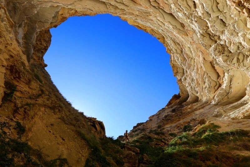
The cavity, which we visited shortly after exploring the Bulyoyyk cave, is an unusual karst formation. In appearance, it resembles a large sinkhole, at the bottom of which open up inclined passages and galleries. For this reason, the term "Utebay cavity" is the most appropriate designation; it describes the feature without restricting its structure to the conventional definition of a "cave."
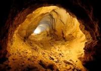
The entrance consists of a sinkhole with steep walls. Inside, there are inclined sections that branch off from the main depression. One of these passages descends at an angle of approximately 40-45° and extends for about 50 meters, at which point the visible portion of the cavity ends.
However, a narrow passage continues beyond this point - one that is small enough to crawl through. Its further direction and total length remain unknown, as this section has not yet been explored. Consequently, the documented length of the accessible area does not necessarily reflect the true dimensions of the underground cavity.
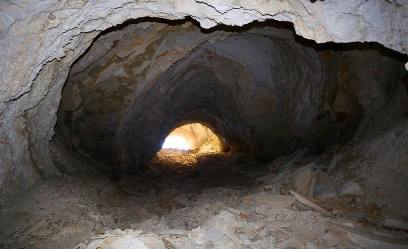
According to the available speleological survey data, a single steeply inclined gallery extends from the bottom of the sinkhole. It is notable for its significant dimensions and spacious sections. The southeastern passage is a tunnel-like gallery measuring approximately 3.5×14.6 m.
It terminates in a dead end after 22.5 m. In the right-hand wall of this dead end, there is a fissure measuring roughly 0.4×3 m, beyond which a potential continuation of the passage can be seen. The northern passage is a short, steeply inclined tunnel, approximately 10-15 meters in length. In its initial section, it descends at an angle of about 45°, reaching a depth of 56 m.
Beyond this point, the gradient decreases to approximately 6%, and the gallery continues for another 40 m or so before ending in a dead end. In the lower part of the northeastern wall, there is an open, slit-like ponor (drainage opening) measuring 1.3×0.53 m.
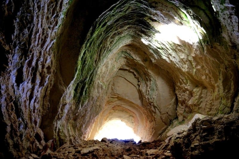
The ceilings of the passages exhibit a stepped, collapse-derived structure. The cross-section of the galleries is predominantly arched, with ceiling heights ranging from 3 to 12 m. The floor is covered by accumulations of large limestone blocks and smaller fragments. In the more remote sections, the debris is mixed with sand and loam.
A distinctive feature of the cavity is the abundance of loose white dust. On the floor and within certain depressions, this layer reaches a thickness of approximately 5 cm. The dust consists primarily of gypsum material and fine particles that have fallen from the ceiling and walls. It coats the limestone fragments, fills small irregularities, and significantly hinders movement and the exploration of narrow fissures and ponors. No traces (footprints or otherwise) were observed on its surface during the visit.
The cavity is dry. A possible exception occurs during a brief period in winter, when heavy - though short-lived - precipitation causes loose surface material to wash into the sinkhole. At such times, the bottom likely becomes a viscous, saturated mass of soil and sediment.
The water gradually drains away into the depths through cracks and sinkholes (ponors). While this observation suggests that the subterranean system is connected to fractured, permeable rock, it does not, by itself, prove that the cavity extends to any significant depth.
No noticeable airflow was observed during the survey. The air temperature inside the cavity was approximately +18 °C. Beyond the sloping entrance lies a fairly spacious chamber, which gradually narrows as one descends. The light-colored limestone surfaces are highly reflective; when the sun is in the southwestern part of the sky, its rays penetrate deep into the cavity, illuminating the interior walls and parts of the floor at a considerable distance from the entrance.
The southwestern part of the sinkhole is also sloped, but it is covered with debris that has either fallen from the walls or been transported there. The bottom of the sinkhole is relatively easy to reach, and the northern section of the small cavernous cavity can be explored directly.
However, the surface is covered in loose limestone and gypsum dust, which makes moving across it difficult.
Geological structure and origin of Utebay cavity.
The Utebay cavity is formed within a sequence of Lower Sarmatian sedimentary rocks. Down to a depth of approximately 60 meters, there is an alternating succession of oolitic, shelly, and microcrystalline light-pink cavernous limestones, interlayered with marls and clays.
Below this lie further alternating layers of marls, clays, and light-pink limestones. This sequence also contains beds of fine-crystalline gypsum - reaching thicknesses of up to 1.5 meters - as well as sandstones and conglomerates. As is the case with the Bulyoyyk cavity, the rock strata that make up the plateau lie in a nearly horizontal, conformable arrangement.
This geological structure is highly significant for understanding the origin of the sinkholes and subterranean cavities found in the Ustyurt region. Limestones - and especially gypsum - are susceptible to dissolution by water. As atmospheric moisture seeps through fractures and the boundaries between layers, it gradually enlarges existing voids.
This process can be particularly intense within the gypsum layers, as gypsum dissolves much more readily than limestone. Over time, cavities, fissures, and complex networks of channels can form underground. When the overlying rock mass loses its stability, sections of the roof collapse.
Funnels, sinkholes, and larger depressions form on the surface, sometimes providing access to subterranean galleries. It is likely that collapse processes played a significant role in shaping the current appearance of the Utebay cavity. However, a precise reconstruction of its developmental history would require specialized geological and speleological research.
Legends of Ustyurt regarding origin of caves.
The Ustyurt Plateau has long fascinated travelers with its unusual landforms. Amidst the vast, stony expanses, one encounters deep sinkholes, precipitous funnels, fissures, and cave cavities. People have offered their own explanations for their origins, linking them to an underworld, hidden waters, and mysterious forces dwelling deep within the earth.
In the popular imagination, such places were often envisioned as gateways to subterranean realms - points where the earth would suddenly split open, revealing a path into the unknown depths. Sinkholes were perceived as traces of ancient events, while passages leading underground were seen as evidence of a hidden world, inaccessible to humans.
Such notions reflected a natural sense of wonder in the face of the Ustyurt’s unusual and harsh landscape. The scientific explanation for these landforms centers on karst processes: the dissolution of gypsum and limestone, the movement of groundwater, and the collapse of rock strata.
Yet, these legends remain an integral part of how the Ustyurt is perceived culturally - a region where natural formations often appear so extraordinary that they naturally inspire the creation of myths and tales. The Utebay cavity is one such feature.
Its large sinkhole, sloping galleries, pale limestone walls, and a floor blanketed in white dust create the impression of a space that extends far beyond what is visible. Further exploration of the narrow passages may reveal an extension of the underground system and help clarify its structure.
Geographic coordinates of Utebay cavity: N42°29'05 E54°38'51




Authority:
Alexander Shakalov.
http://speleokz.ucoz.ru
Alexander Petrov.
Photos by:
Alexander Petrov.