


![]()
You are here
Zaalaisky Range.
Tours to Zaalaisky Range in Pamir mountains.
“Search, search my voice on the air
A little hoarse, for good reason -
After all, our Pamirs are in the Pamirs
And we are a little higher than these peaks”
Yuri Vizbor. "Pamir song"
Jeep safari in Zaalaisky Range.
Zaalayskiy (Kayumars) ridge is located in latitudinal direction, its southern slopes rush towards Tajikistan. Central and eastern part of Zaaalayskiy ridge is located on territory of Murgab region of Gorno-Badakhshan Autonomous Region, western part of ridge is partially located in Sughd region of Tajikistan. Northern slopes of Zaalayskiy Range are located on territory of Chon-Alai district of Osh region of Kyrgyzstan. State border between Kyrgyzstan and Tajikistan runs along central part of ridge. Zaalayskiy Range belongs to mountain system of Pamir Highlands.
The Zaalaisky ridge is located in the latitudinal direction, its southern slopes rush to Tajikistan. The central and eastern part of the Zaalaisky ridge is located on the territory of the Murgab district of the Gorno-Badakhshan Autonomous Region, the western part of the ridge is partially located in the Sogd region of Tajikistan.
The northern slopes of the Zaalaisky Range are located on the territory of the Chon-Alai District of the Osh Region of Kyrgyzstan. The state border between Kyrgyzstan and Tajikistan runs along the central part of the ridge.
The Zaalaisky Range belongs to the mountain system of the Pamir Highlands.To the south of the pearl of Central Asia, as the Ferghana Valley has long been called, there is a system of ridges, valleys, and deep gorges that fill a vast territory reaching the Pamirs in the south. Here are the Alai Range, Alai Valley and the Zaalayskiy Range.
These three large orographic units are commonly called Alai. Both ranges in their natural landscapes have much in common, which allows them to be distinguished as an independent mountainous region. One of the first researchers of the geological structure of Central Asia I.V. Mushketov (1886), in his classic work Turkestan, came to the conclusion that the spread of the Tertiary-Cretaceous deposits proves that in the recent geological era the mountain systems of the Tien-Shan, Alai and Pamir were completely separated from each other.
Everywhere I.V. Mushketov calls this part of the then Turkestan the Pamir-Alai mountains, or the system of mountains. Different scholars have expressed different opinions on the question of the partition of the mountains of Central Asia. L.S. Berg (1947) assigns almost the entire mountainous region in the southeast of Central Asia to the Tien-Shan, separating only the Pamir from it.
Later researchers - S.S. Schulz (1948) and N.A. Gvozdetsky (1959) - the Ferghana Valley is considered the border of the Tien-Shan (in the south). They distinguish more southern ranges into the Pamir-Alai system.
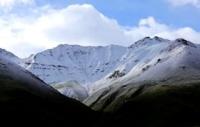
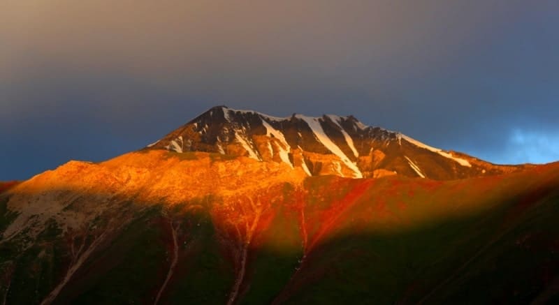
The Zaalaiy ridge, in the central part of which (its highest point is Lenin Peak (7134.3 m)), (forms the northern border of the Pamirs. This ridge stretches 150 km in the latitudinal direction and borders in the east with the extreme western spurs of Kokshal-Too (Tien -Shan), and in the west it wedges out near the confluence of the Muksu and Kyzyl-Su rivers of the ridge exceeds 6,000 meters above sea level, the southern slope facing the Pamirs rises 2,000 to 2,500 meters from the bottom of the high valleys.
The ridge is especially majestic from the side of the Alai Valley. From above, at three quarters of its height, the slopes of the ridge are covered with massive snow The rock base is visible only below, rock formations composing it have different colors - black, burgundy and dark brown.
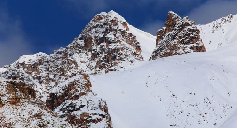
White streams of ice creep down from the snow cover wrapping the ridge. In the extreme east of the ridge, at the headwaters of the East Kyzylsu River, the trapezoidal peak of the Dawn of the East rises 6346 meters above sea level.
To its right is the enormous snow mass of Kurumdy 6610 meters above sea level, translated into Russian as “visible”. Even more to the right, opposite the village of Sary-Tash, over a deep gorge, through which, according to old legends, a smugglers trail went, Pogranichnik peak rises 5434 meters above sea level.
Further west of Pogranichnik Peak lies a fairly wide valley through which the Pamir Highway passes. The Korzhenevsky mountains (the highest point of the ridge - 6075 meters above sea level, named after the tireless explorer of the Pamir, lie west of the Pamir tract.
The snow ridge of the Korzhenevsky mountains almost immediately passes to the giant peak of Kyzylagyn, or the Red Stream 6679 meters above sea level. It goes beyond Kyzylagyn Barrikad ridge, and then Lenin Peak.
Three peaks, almost identical in shape, but different in height, rise above Lenin Peak. They are named after the closest associates of Ilyich - Dzerzhinsky 6713 meters above sea level, Krasina 5996 meters hell with sea level and Tsuryupa 5845 meters above sea level.
The last peaked peak of the visible part of the Zaalaysky ridge, rising in the form of a regular trapezoid, is called Sverdlov’s peak 5451 meters above sea level, named after the first President of the Soviet State.
These names were given in early August 1928, the leaders of the Soviet-German expedition, NP Gorbunov, NV Krylenko and O. Yu. Schmidt, who formed the so-called “mining commission”.
The participants of the "mining commission" secured their names with the appropriate protocol and instructed the surveyors of the expedition to accurately determine the location and heights of these peaks. Over the Sverdlov peak, the Zaalaysky ridge is cut through the Altyndara Valley, to the west of it and the Tersagar Pass the ridge continues to be a first-class rise with heights of more than 5000 m above sea level.
At the western end of the ridge, the Kyzylsu River (from the Alai Valley) and the Muksu River (from the Fedchenko Glacier and the southern slopes of the Zaalai Range) merge, forming the Surkhob River, which even later takes the name Vakhsh and, connecting with the Panj, forms the Amu Darya.
The slopes of the Zaalaisky ridge are steep, indented by a system of short wide valleys, which are closed by almost vertical walls of circuses. Numerous glaciers descend through the valleys. In the Cenozoic era, the rise of the Pamirs and its destruction began.
The low elevations of the Pamirs at the beginning of the Paleogene, as a result of general uplift and increased erosion, turned into huge rocky ridges with steep slopes and deeply incised gorges. This process culminated in the Neogene with strong fold formation and uplift.
This main phase of alpine folding was completed design fan-shaped folding structure of the North Pamir Anticlinorium. With the movements of that time, the beginning of the formation of the Zaalaysky ridge was also connected.
The continuing rise of the Zaalai Range relative to the Alai Valley is expressed in distinctly terraced river valleys within the mountains and the rapid attenuation of terraces in the Alai Valley. The modern glaciation of the Zaalai Range is very significant and stands after such large glacial centers as Fedchenko (Pamir) and Inylchek (Tien-Shan).
The weak dissection of the crest of the Zaalaysky ridge and the huge absolute height led to powerful modern glaciation. As in the past geological era, and now the highest point of the ridge - Lenin Peak serves as the center from which the largest glaciers of the Zaalai ridge flow in all directions, forming the main node of modern glaciation.
For 20 years, from 1945 to 1965, glacial tongues underwent significant changes: they retreated. So, the Lenin glacier during this time receded by 1300 meters, as a result of which there was a separation of its eastern and western branches.
It lost 15% (compared to 1945) of its original length and 2.4 kilometers square area. If the capacity of the retreating part of the glacier is taken as an average of 20 meters, then the volume of ice melted over 20 years will be about 50 million cubic meters.
Since 1969, the glacier began to "advance" and may soon return to the 1950s position. This "offensive" is a consequence of the sliding of firn-ice masses from the slopes as a result of the contraction of the glacier.
The Oktyabrsky Glacier, lying on the southern slope of the central part of the ridge, is one of the largest valley glaciers in Central Asia. It can be attributed to the type of “two-story” glaciers allocated by K.K. Markov for the Pamirs and Visser for the Kara Korum. Currently, the “young” pure white stream of the Oktyabrsky Glacier cannot be considered the “second floor”.
He tore apart the older glacier beneath it and deepened into the bed of the valley. Exazration (plowing of its bed with a “young” glacier) dramatically changed the whole appearance of the Oktyabrsky glacier. Plowing destroyed and separated from the live part about two-thirds of its width.
Thus, the more ancient glacier is no longer the “first floor” glacier. This glacier now lies higher than the average living part of the stream, which has sunk into the bottom of the valley. Broken into blocks, an older glacier almost lost the ability to move, it quickly collapses, melts.
The language of the Oktyabrsky glacier now accounts for 30.3% of the area it occupied in 1946. The modern relief of the flat part of the Alai valley is disrupted by relict formations of ancient glaciation, which covered the entire Alai.
In the eastern part of the valley adjacent to the Zaalaysky ridge, the modern relief can be characterized as moraine-hilly. Here, vast areas (more than 250 sq. Km) are entirely occupied by the so-called “Chukurs” - an erratic alternation of hills and depressions, which are also characteristic of the surface of glacial tongues that are in a stage of degradation (retreat).
This "chukurny" relief was formed, apparently, in the penultimate phase of glaciation, after glacial tongues crawled out into the valley. The offensive period quickly gave way to the reverse process. Languages lacking an influx of ice began to melt, leaving behind a hilly relief, called the first explorer Alai A.P. Fedchenko "Chukur".
The Alai Valley, spreading at the foot of Lenin Peak, starts from the Taukmurun lintel (Chicken Beak), which connects the Alai and Zaalai ranges with a low ridge. From the foot of this ridge (height 3378 m), it stretches to the west for 135 kilometers.
Between the foothills of both ranges, the valley extends from 8 - 10 to 20 - 22 kilometers, its entire area is 1800 square kilometers. The extreme lower part of the Alai Valley lies at an altitude of 2362 meters above sea level near the village of Katta-Karamyk. In the glaciers and snowfields of the Alai and Zaalaysky ranges, streams begin to merge with the Kyzylsu River, which flows in the Alai Valley.
Behind the Taukmurun ridge are the sources of another river of the same name. This river - Kyzylsu (Vostochnaya) - flows to Kashgar. By natural conditions, the Alai Valley can be divided into two almost equal halves - eastern and western.
The temperature in the upper, eastern part is about 2 - 2.5 ° lower than in the western. Precipitation here is much greater - 720 - 750 mm (in Sary-Tash), and in the west - 540 mm (in Darautkurgan). In its landscape, the upper part of the valley is an alpine semi-desert.
Fescue steppes with feather grass are characteristic of this part of the valley. Pebble steppe terraces covered with a layer of fine earth located in the western part are characterized by wormwood formations typical of semi-deserts.
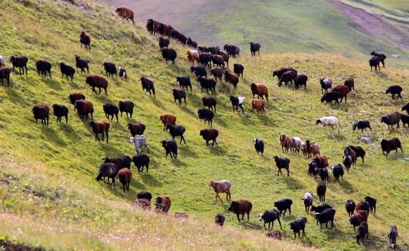
If you look at the Alai valley from the Saryk-Mogol pass (the middle part of the Alai), then its eastern part will appear green, and the western one will be yellowish-gray. Alai Valley serves as a good pasture for livestock.
From the north, through the Karakyzyk and Tengiz-bai passes and a number of other less well-known routes, numerous cattle-driving paths lead here. From the south, from the Eastern Pamir, they use the Kyzylart pass for cattle distillation.
|Geographic coordinates of beginning of Zaalayskiy Range: N39°10'37 E71°33'06
Geographical coordinates of middle position of Zaalayskiy Range: N39°20'56 E72°52'46
Geographical coordinates of end of Zaalayskiy Range: N39°28'57 E73°52'33


Authority:
Vladimir Iosifovich Racek, “The Five Highest Peaks of the USSR”, Uzbekistan Publishing House, Tashkent, 1975.
Photos by:
Alexander Petrov.