







You are here
N.M. Prokopenko. Crossing Central Tien-Shan. 1929.
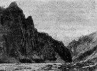
N.M. Prokopenko. Crossing Central Tien-Shan.
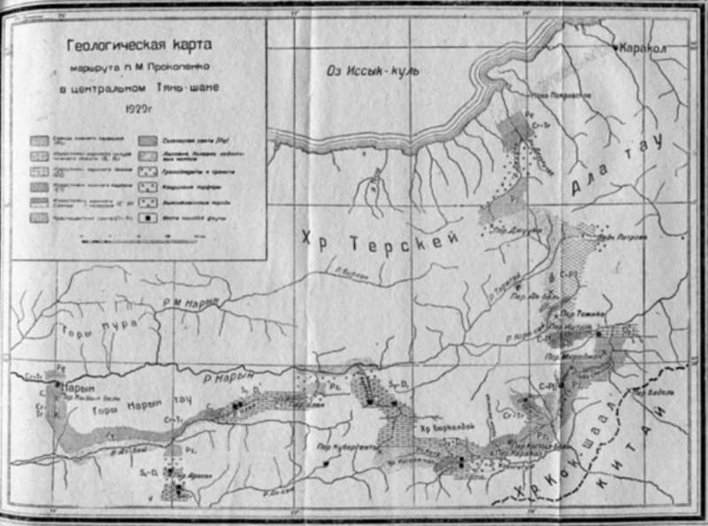
“In the summer of 1929, the Tien Shan expedition of the USSR Academy of Sciences, consisting of the head of the work N.M. Prokopenko, researcher B.A. Gavrusevich, with two workers, crossed the Central Tien Shan along the route Karakol - Uzengegush - Naryn. The expedition's main task was to explore the thermal springs of the central Tien Shan. Having equipped itself in the city of Karakol, the expedition traveled by pack route to the city of Naryn along the following route: the Dzhuuka pass, the Petrov glacier, the Ak-bel, Ishtyk and Murodzhan passes, the Ichke-su and Tasma-jun-kapchigai rivers (with reconnaissance along the Kainar river), the Kyzyl-bel and Karakoz passes, the river. Uzengegush, r. Kotr, Kubergenty pass, Karakol, Ulan and At-bash rivers (with reconnaissance to the Bezbelchir-arasan key), Kyzyl-bel pass, Naryn. Thus, the research mainly covered the syrt strip of the central Tien Shan, adjacent to the northern and northwestern slopes of the Kok-shaal ridge. The entire route from Karakol to Naryn was covered within a month and a half, and geological observations were carried out only along the way, while carrying out the main task of studying thermal springs. Transition from the Ishtyk pass to the mouth of the river. The expedition made Kotre together with a border patrol. I express my gratitude to the head of the patrol, Comrade Biryukov, for the assistance provided. From the city of Naryn, the expedition traveled westward along the river valley. Naryn (with a stop at the mouth of the Alabuga River to study thermal springs and lead deposits) and passing through Kugart, completed work in the city of Jelal-abad.”
Geomorphological observations along route Karakol - Uzengegush - Naryn.
The composition of our group: N. M. Prokopenko, B. A. Gavrusevich and two workers. The path from the city of Karakol to the entrance to the Dzhuuka gorge passes through the populated cultural zone of the Issyk-Kul basin. In the area of the foothills of the Terskey Ala-Tau ridge, the lower part of the river valley Juuka is erosive for about 15 km.
The river flows in an area of development of easily eroded sedimentary rocks in a wide, spacious valley. When leaving the mountains, the latter is 1.5-2 km wide, gradually narrowing to 250-300 m at the confluence of Dzhuuki and Dzhukuchak Initially, yellowish-gray sandy-clayey lifeless cliffs of salt-bearing (lake) deposits stretch along the river.
The landscape here is semi-desert. Above the border outpost, the landscape takes on a more colorful appearance. Here the gorge passes among the spectacular cliffs of the red continental suite. In the lower reaches of the river. Juuk there are four terraces, of which two more well-defined lie at an altitude of 25-31 m and 45-52 m. a. s. l.
The terraces are made of medium-pebble material and are covered on top with yellowish-gray, non-layered loess-like loam up to 3-5 m thick. On the right bank of Dzhuuki, near the confluence of the latter with Dzhukuchak, river pebble terraces unconformably overlie red-colored sediments.
Dzhuuka above the confluence with the high-water river. Dzhukuchak deviates from its original northwestern direction to the south, acquiring a meridional direction. The widened part of the valley, associated with the development of easily eroded red rocks, stretches along Dzhukuchak for another 1 km, and then gives way to a narrow (25-40 m) and relatively deep (30-50 m) canyon, cut through grano-diorites over a section 3-4 km long.
Here, for the first time, a spruce forest appears on the slopes, which descends somewhat higher to the river bed itself. The river flows quite calmly in the canyon, but in its upper reaches it falls with noise and roar in the form of cascades along a steeply falling bed, cluttered with large granodiorite boulders.
This section of the river's flow. Juuka is characterized by a break in the longitudinal profile of the valley. Here, young river erosion conceals the trough glacial relief developed upstream. The river deepened its bed, forming below the threshold a typical narrow canyon cut through granodiorites.
The bottom of the trough is still preserved in places above the canyon in the form of shoulders. It is cluttered with moraine large boulder material. Leaving the forest covering the bottom of the gorge near the river cascades (from the confluence of Dzhuuki with Dzhukuchak to the cascades about 5 km), we find ourselves in an area of typical glacial topography.
The picture changes dramatically. The river valley takes on a trough character. Its trough-shaped spacious profile (up to 0.5 km wide) is characterized by a flat, slightly hilly bottom. The lower parts of the slopes are hollow. In most cases, they are turfed, in places covered with screes of granodiorite rocks, which are sometimes joined by cones of the mouths of lateral rivers.
Above, the valley slopes are steep, almost vertical in places. They are covered with sparse spruce forest, sometimes descending to the riverbed (near the canyon and 1 km below the mouth of the Kashka-Su River). The granodiorite ridges of the hills surrounding the valley on both sides reach 1.5-2 km above the valley floor.
In the upper part, they have sharp rocky outlines. Small glaciers lie in the upper reaches of the right side channels. The Dzhuuka River flows along the bottom of the trough, although quite rapidly, but relatively calmly, without forming turbulent cascades.
The riverbanks are low, without terraces. The valley floor is pebbly in places, marshy in others, with a hummocky grassy surface. Receiving the fairly full-flowing Kashka-Su River (2477 m) on the right, the Dzhuuka River deviates from its meridional direction to the southwest.
Between the mouth of the Kashka-su and the Dungurme River, the Djuuka flows between the schist uplands of the right bank (the axial part of the Terskey Alatau ridge) and the granodiorites and quartz porphyries that make up the left bank. The Djuuka Gorge at this location is likely of tectonic origin.
A similar east-northeast direction is also typical for the Dungurme River and the Uch-imchik River. The Djuuka Gorge in its upper reaches runs along the contact line between dissimilar rocks (granodiorites and schists), and under such conditions, faults occur particularly easily during tectonic movements.
Porphyry outpourings above the mouth of the Kashka-su are likely confined to one of the tectonic fractures associated with the aforementioned fault. The spacious trough profile of the valley continues to the Dungurme River, widening to 0.7 km.
Above the mouth of the Kashka-su River. The bottom of the trough is lined with moraine from ancient glaciation, but no terminal moraines are observed here. The Dzhuki River trough can be traced for approximately 25 km, beginning 4-5 km above the confluence of the Dzhuki and Dzhukuchak Rivers and ending at the mouth of the Dungurme River, at an altitude of 2908 m. a. s. l.
During the Quaternary, the Dzhuki Valley was home to a large glacier, and the main valley was overdeepened relative to the glaciers descending from the side gorges. Modern river erosion has only slightly affected the glacial relief, and only in the lower part of the trough does it obscure the valley's trough-shaped profile, carving a narrow canyon into it.
From the mouth of the Dungurme River. Near Dungurme (where the upper boundary of the spruce forest is located), the Dzhuuk Gorge turns southeast, heading toward the axial part of the Terskey Alatau ridge. The gorge is transverse in nature, cutting across a phyllitic schist formation.
A small river flows through a narrow canyon, compressed by enormous scree slopes descending from high schist ridges. This part of the upper reaches of the Dzhuuk River is an area overdeepened by recent river erosion. Above the lakes, glacial phenomena again predominate.
The trail soon leads to a small (0.5 km long, 50-100 m wide) moraine lake, above which begins a steep climb along a huge terminal moraine (100-150 m above lake level), consisting of a disorderly pile of large angular granodiorite and phyllitic schist blocks.
This moraine completely blocks the gorge. Above it, a second (upper) glacial lake has formed, with no direct downward drainage. Water from it, seeping through the moraine, flows into the lower lake, from where it flows out as a small river. From the top of the moraine (3,390 m), a vast view opens onto the typical glacial landscape of the upper Juuka River.
On the southern side of the moraine, at its foot, lies the upper glacial lake (200 m at 0.5 km, 3,305 m abs.) with a beautiful greenish-blue color. From the high phyllitic schist and granodiorite walls of the gorge, huge steep scree cones descend toward it.
Above the lake, the gorge profile is wide (0.3-0.5 km), trough-shaped. The mountain peaks are covered with snowfields. The landscape is gloomy but majestic. Skirting the moraine lake on the eastern side, the trail runs along the left bank of the gorge among continuous large-boulder granodiorite scree.
The ascent to the pass is along a steep, slightly developed path, the condition of which in the section between the upper lake and the Dzhuuka Pass must be considered poor, despite the fact that it was somewhat improved during the construction of the Tien-Shan Observatory.
The ascent to the pass with a normal pack and in good weather is not difficult, but it becomes significantly more difficult in inclement weather. At the top of the gorge, as you ascend the pass (above the second lake), two or three small ledges (bars) in the bedrock (granodiorite) are visible.
Perhaps these ledges formed during temporary pauses in the glacier's general retreat. From the Dzhuuka Pass (3,645 m), a unique view opens up. The first thing that strikes us is the lack of any descent from the pass to the south. Before us lies a fairly wide (1-1.5 km) valley with a trough profile, cut into the plateau-like elevation of the central part of the Terskey Alatau ridge.
This valley drains (a small stream flows through it, then falls into the Dzhuku Gorge) toward the pass. It undoubtedly represents the headwaters of the ancient Dzhuuka River valley. The remaining 2.2 km-long section (between the pass and the lakes south of it) has escaped erosion, perhaps in part because it was preserved by glaciation, while the rest of the valley, located north of the pass, was heavily eroded.
The route from the Dzhuuka Pass southward passes through a swampy, hummocky valley. 2.2 km from the pass lies a fairly long but narrow (2.5 km long, 50-200 m wide) moraine lake, from which a small river flows north. The snow-covered crest of the Terskey Alatau range slopes gently to the southwest, toward the syrts, gradually merging with them.
The plateau-like topography of the highest part of the ridge (4,050-4,480 m) indicates that we are dealing with the remains of an ancient, Mesozoic peneplain surface here. Starting from the Dzhuuka Pass, we enter a region of typical high-mountain syrts, with their bleak landscape and inhospitable, usually cold, weather.
The syrts of the upper Naryn River are wide buried valleys, partially filled with moraine and fluvioglacial deposits. Numerous glacial boulders cover their surface, and small lakes of moraine origin are common. Numerous streams flow through the valleys, creating, due to permafrost, swampy soil in the lower reaches. In general, the syrts of the upper Naryn River are broad, high-altitude valleys (3,600-3,700 m) with gently rolling terrain, covered with lush grassy vegetation but completely devoid of forest.
Continuing on, we cross a low ridge and enter the Arabel-Su River basin. The landscape retains the typical appearance of syrts, with their glacial lakes and valley swamps. To the south, the mountains rise, including the Jetym-bel Pass, covered with low-lying snowfields descending toward the syrts.
In the distance to the east, the Ak-Shiyryak mountain group is clearly visible, stretching meridionally with numerous glaciers and a very low snow line above the syrts. From the western slope of the Ak-Shiyryak Mountains, the powerful Petrov Glacier (16.8 km long, 2-2.2 km wide) descends toward the syrts.
This glacier is typically characterized by a strongly developed feeding area compared to the area of its tongue (L.K. Davydov, 4). The lower part of the glacier is covered with transverse crevasses, glacial tables, and melt funnels. The ice surface in this area is heavily littered with moraine material, consisting of blocks and fragments, primarily of gray granite.
On the right, northern side of the glacier, a fairly well-defined lateral moraine is visible, along which we ascended 3 km from the end of the glacier. The glacial tongue terminates in a small lake (absolute altitude 3,786 m), adjacent to the youngest, not yet turfed, terminal moraine.
The second terminal moraine runs parallel to the first. It is partially turfed, containing remnants of dead ice. The third, oldest moraine, is located furthest from the glacier to the west. The ridges of the terminal moraines rise several tens of meters above the valley floor.
They consist of a disorderly accumulation of small and large granite boulders. The Kum-Ter River valley below the Petrov Glacier was carved by older glaciation and is lined with moraine and fluvioglacial deposits. 7-8 km west of the Petrov Glacier, on the right bank of the Kum-Ter River, the Tien-Shan Meteorological and Glaciological Observatory was completed in 1929 at an altitude of approximately 3,600 m.
The observatory's purpose is to study the water regime of the upper Naryn River and the meteorology of the high syrts. During the observatory's construction, permafrost was discovered at a depth of 70-90 cm below the ground surface. This phenomenon is undoubtedly widespread in the high syrts region.
Northwest of the Petrov Glacier lies the plateau-like ridge of the Terskey Alatau Mountains, which drops steeply to the north due to more intense erosion and gradually descends toward the syrts to the southwest, where it is cut by a series of short gorges (Dzhuuka, Ityshi, Kashka-su, Dzhukuchak, and others).
Where the plateau merges with the syrts, clear traces of glacial activity are visible: the hilly terrain, dotted with small moraine lakes, is covered with numerous granodiorite boulders. Leaving the Tien Shan Observatory, we headed south to the Ak-Bel Pass.
The Kum-ter River, which originates from the Petrov Glacier and is the headwaters of the Naryn River, flows through a spacious, well-developed valley up to 3-4 km wide. The valley probably previously had a trough profile, but was subsequently filled with glacial and fluvioglacial deposits.
The river is divided along the pebble bed into numerous branches, easily fordable. The dark, not covered with vegetation, shale slopes of the Ak-shiryak ridge have a gloomy appearance. In small gorges going down to the river. Kum-ter, there are glaciers with well-defined terminal moraines.
The general type of landscape is high-mountain desert. The Ak-Bel pass (3812 m) has the character of a ridge with a slight elevation above the syrts, so climbing it is not difficult. Glacial boulders are visible everywhere on the surface. Probably, in Quaternary times the pass was occupied by a sweeping glacier.
Descent from the Ak-Bel pass to the river. Karasai passes among stacked shale hills, sometimes turfed, sometimes covered with screes. River Valley Karasai is well developed, up to 0.5-1 km wide, with a fairly high-water river (up to 10 m wide) flowing along a pebble bed.
The slopes are covered with sparse grass. Four terraces are developed along the valley, of which the two most clearly preserved have a height of about 20 and 80 m.a.s.l. u. rivers Through the Tozhike pass (3531 m), characterized by a slight elevation above the Karasai valley, the path leads to the spacious, up to 4 km wide, Kara-geru valley.
The river appears only east of the Tozhko-ishtyk path and belongs to the river basin. Sary-jass. Both river erosion and glacial activity participated in the development of the relief of the Kara-geru valley. The flat bottom of the valley is probably due to the fact that it was partially filled at the end of the Ice Age with fluvioglacial sediments (buried valley).
Near Lake Pater-beshik (3603 m), the landscape becomes somewhat livelier. The abundance of water and lush grass attract Kyrgyz nomads here. The Ishtyk pass (3640 m) is a fairly wide saddle with a slight elevation (40 m) above the Kara-geru valley.
The area is layered with limestone, with poorly developed karst phenomena. In the upper reaches of the river valley. Ishtyk is spacious, slightly swampy and covered with meadow. Closer to the mouth of the river. Borkoldoy it narrows to 30-50 m.
The river is small, 5-6 m wide, with two terraces: one 15-20 m high, the second 45 m (rivermen at the mouth of the Borkoldoy river). In the lower reaches of the river. Borkoldoy, on the right bank, four terraces are visible. The ridge of the Borkoldoy ridge has a more or less even outline, with small snowfields on the northern slope.
The ascent to the Tura-booz pass (3612 m) is not difficult. The path runs along the gentle, hilly slope of the Borkoldoy ridge. The pass offers views of the well-developed erosional terrain of the area. The river valley, formed after the confluence of the Booz-jalpak, Bedel and Kara-bel rivers, is deeply cut into shale rocks.
The river gorge is also deeply cut into the shale. Min-Teke, and its right slope, composed of limestones (Tekele-tur tract), with a plateau-like upper surface (4028-4267 m), gradually descending to the north. This is probably a remnant of peneplain.
The river, formed after the confluence of the three rivers mentioned above, cuts through these limestones in the Myn-gozyr tract with a narrow, epigenetic canyon. The general character of the relief of this area is already characterized by a significant participation of erosion processes.
The formation of the relief here has gone much further than in the area of the high syrts of the upper reaches of the river Naryn. Starting from RF. Ishtyk and along the entire further route to the city of Naryn, with the exception of only small individual sections of the route, the river valleys are significantly deepened by erosion processes and the influence of glacial phenomena on the relief affects mainly in the upper reaches of river systems.
A river gorge cut deep into shale. Murodzhan is narrow (15-30 m wide), with small screes on weakly turfed slopes. The ascent to the Murodzhan Pass (3761 m) is gradual and easy. There is no woody vegetation. The landscape is monotonous and lifeless.
Steep descent from the pass to the river. Booz-jalpak passes among shale screes. RF The Booz-jalpak flows in a spacious (0.7-1 km) well-developed valley with gentle shale slopes covered with grass. Red deposits are quite widespread here.
The river's floodplain is pebble (200-300 m wide) with numerous channel beds reaching 7-8 m wide. The river is accompanied by a terrace cliff about 25 m high. Through the low Karasai ridge (3752 m) we find ourselves in the upper reaches of the river. Karasai, already belonging to the river basin.
Uzengegush. Minor RF. Karasai flows in a narrow (30-80 m) erosive shale gorge with sloped slopes. The red-colored conglomerates developed in the valley of this river give the area a unique appearance, characteristic of these deposits. Gorge river Ichke-su has a typical erosional topography.
Its depth, in relation to the surrounding hills, is 500-680 m. The gorge is narrow (30-50 m), with high steep shale slopes of a greenish-gray color, almost completely devoid of vegetation. In many places the slopes are colored yellowish-gray by loess-like loam.
Screes are quite widely developed, in places heavily cluttering the gorge. Bottom of the gorge The gorge is lined with gravel, through which the Ichke-Su River flows, reaching a width of up to 8 meters in its lower reaches. The gorge has a rather monotonous, semi-desert appearance, dominated by physical weathering and devoid of vegetation.
Only in the lower reaches of the river, at an altitude of approximately 3,200 meters, do low thorny bushes first appear. The valley of the Kainar River, where we made a side excursion to the Kainar-mazar springs, is initially eroded (50-00 meters wide), and higher up, near the springs, it becomes trough-like (200-300 meters wide).
The slopes of the hills are partly grassy, partly covered with scree, and the lower reaches of the river are overgrown with tall grass. After fording the full-flowing Kichik-uzengegush River, we entered the well-developed shale gorge of the Emegen River.
The landscape here remains typical of shale rock. Rocky cliffs, partially covered in a black crust of desert tan, are bleak and monotonous. Talus is widespread. The river is small, 5-6 meters wide, and its lower reaches are overgrown with small shrubs.
The gorge of the Tasma-Dzhun-Kapchigay River is difficult for pack horses to navigate. In its lower reaches, it is narrow (20-50 meters) and littered with pebbles and scree. The landscape remains typical of the shale belt. In its upper reaches, the gorge is also narrow (20-30 meters), with high, rugged slopes covered with lush, grassy vegetation.
Even higher up, near the pass, the valley widens. The high cliffs of the left bank stand out in stark contrast to the overall green landscape of the valley. The Kyzyl-Bel Pass (3,776 m) offers an easy climb over soft ground. From the summit of the pass, a magnificent view opens onto a grand panorama. In the distance, to the southwest, the snow-capped masses of the Kok-Shaal Range stand out clearly, resembling enormous sugar loaves.
The topography of the ridge's crest is characterized by the sharp outlines of individual peaks, reaching 5,183-5,879 m in absolute elevation. The elevations near the pass are composed of red-bedded deposits with a landscape typical of these deposits.
The descent from the Kyzyl-Bel Pass along the Shaldrak Gorge is quite steep. Initially, it passes through red-bedded conglomerates, and below, through Lower Paleozoic shales cut by the Shaldrak River, a narrow (15-25 m wide) canyon with steep walls.
Having forded the fairly deep Cholok-kap-chigai River (10 m wide, with high water presenting some difficulties), we began the climb up a steep, rather difficult trail to the Karakoz Pass (3,783 m). The ascent initially leads through a narrow shale gorge, and further up along the folded, sod-covered slopes of a red-colored formation.
From the Karakoz Pass, a vast view opens up of the Kok-Shaal Ridge and the Uzengegush River valley. The slopes of the Kok-Shaal below the ridge crest are a staly gray color, likely shale, cut by deep gorges. In this ridge, below the main peaks, several distinct, flat, seemingly peneplain surfaces are observed.
From the Karakoz Pass to the Uzengegush River, a descent leads along a steep, narrow gorge, at the mouth of which is a ford crossing over the river. Uzengegush. The width of this river here reaches approximately 20-25 meters, with a water depth of 1-1.5 meters and a fast current.
At high water, fording is difficult. The extensive (1-1.5 km wide), well-developed valley of the Uzengegush River, in the section between the descent from the Karakoz Pass and the mouth of the Kotr River, is asymmetrical. Its right slopes are flat, with a wide terrace smoothly transitioning into the valley slope; the left slopes are steep and precipitous, with the riverbed pressed against them.
At the mouth of the Kotr River (3,234 m), the Uzengegush flows through a wide (up to 0.5 km) pebble floodplain, breaking up into numerous branches. Along the river Uzengegush features four terraces, approximately 2 m, 10 m, 30-40 m, and 55 m above river level.
The third, widest (50-300 m), terrace appears as a spacious, level area on the right bank of the river. The Kotr River, originating on the southern slopes of the Borkoldoy Ridge, has deeply cut a canyon-like gorge through a suite of Upper Silurian-Lower Devonian limestones.
In the eastern part of the Kogolya-chap tract, the Kotr River flows in a canyon up to 50-60 m deep, with red conglomerates lying along its edge. The peaks of the Borkoldoy Ridge are high (4766-5043 m) gray limestone ridges with sharp, ribbed outlines. Snowfields and glaciers are widespread.
The mountain slopes facing the Kogolya-chap Valley are surrounded by extensive scree. The valley floor is covered with a rather sparse grass cover. The Kogolya-chap Valley and its continuation to the west, the upper Aksai Valley (45 km long, 5-8 km wide, and 3,500-3,600 m abs. altitude), form a vast, syrt-like high-mountain basin.
It frequently contains moraine lakes and large granite boulders (such as those southwest of the Kubergenty Pass), sometimes with a volume of several tens of cubic meters, leaving no doubt of their glacial origin. They were brought by glaciers from Kok-shaal during the Quaternary.
Through the Kubergenty Pass (3,909 m), a low ridge above the Kogolya-chap Valley, we pass from the river basins. The Uzengegush and Aksai rivers flow into the Naryn River basin. The Kara-Chukur gorge is quite spacious (0.5 km) and marshy.
In the Kelin-taygak tract, the river cuts through limestone in a narrow canyon, up to 50 m deep. After the confluence of the Dzhang-Dzhira and the Dzhagalmay (3,273 m), the river takes on the name Karakol. The latter flows in a spacious (0.5-0.7 km), well-developed valley, surrounded by high limestone ridges with typical, sharp outlines.
The ridges rise 1,000-100 m above the valley floor. The limestone ridges, stretching along the slope, one lower than the other and usually separated by scree, have characteristic shapes. The river floodplain is pebble-covered (50-100 m wide).
The Karakol River, up to 15 meters wide at its mouth at the At-Dzheylyau River, is full-flowing but easily fordable. In the upper reaches of the river, two terraces, 10-15 and 50 meters high, are developed, covered with yellowish-gray loam up to 0.5 meters thick.
A soil horizon 15 cm thick lies above the loess-like loam. In the lower reaches of the Karakol River, three terraces are observed: 18 meters, 32 meters, and 52 meters high. The general appearance of the landscape remains the same here: high, bare hills, often with small scree slopes.
The Naryn River flows in a spacious (2-3 km) valley with a gently concave cross-section. On the peaks of both banks, near the mountain crest, snowfields lie in typical cirques. Along the Naryn River, between the mouths of the Karakol and Ulan rivers, three terraces are developed.
The lower part of the Ulan-Vostochny River flows through a narrow erosional gorge. The river is 3-5 m wide, and one terrace approximately 20 m high is visible along it. Two kilometers upstream from the mouth of the Kunan-Ash River, the Ulan valley acquires a wide (up to 0.5 km) trough profile.
In the middle part of the valley, 5 km below the pass, on the high elevations of the river's right bank, two glacial cirques are visible. The cirques are well-developed, wide (0.5-0.7 km), and surrounded by high rocky ridges. Snowfields lie at the bottom of the cirques.
The hanging valleys of the cirques are especially visible if you ascend a little to the elevations of the left slope of the valley. The middle part of the river valley Ulan is covered with a fairly dense grass cover, attracting nomadic Kyrgyz here. Above here and right up to the Ulan Pass, the gorge is equally wide, covered with gray limestone scree.
One kilometer from the pass, the valley is almost completely blocked (leaving a narrow space for the river to flow) by a large alluvial fan consisting of blocks and fragments of gray limestone of S2+D1 grade. The fan descends from a cirque on the right bank of the valley.
At the head of the cirque, a snowfield is visible. It is possible that this is not just an alluvial fan descending here, but a small glacier, covered on top by a layer of limestone fragments. The ascent to the Ulan Pass (3,793 m) is easy, gentle, and strewn with small calcareous pebbles washed out of the red-bedded formation that develops here.
The landscape takes on a high-mountain desert character. The descent from the Ulan-Zapadny River pass takes place in a wide (100-300 m) trough-like shale gorge. Glacial cirques are visible on the left slope of the valley. In the middle part of the valley, below the mouth of the Teepshi River, three terraces are visible: 3 m, 15 m, and 45 m high.
The middle and especially the lower part of the Ulan-Zapadny River gorge has been greatly deepened by river erosion. The upper slopes are high gray limestone ridges (1000-1200 m above the gorge floor), with isolated prominent peaks. The red-colored formation that fills the gorge floor has been deeply cut by the modern river, forming a narrow (20-50 m) and deep (up to 100 m) canyon with almost vertical walls.
The slopes above the canyon are covered with tall, lush grass. Starting at an altitude of 3,250 m and for the first time along the route, juniper thickets appear, and below, at an altitude of 3,100 m, spruce forests appear, the upper boundary of which is 2 km above the mouth of the Dzhangdzhir River.
Three terraces are developed 0.5 km below the confluence of the Ulan-zapadny and Dzhangdzhir. The At-bash River valley is wide (0.5-1 km) with a smooth, flat bottom, deepened by river erosion. The river flows between high (50-60 m) pebble cliffs (terraces).
The left slope of the valley is overgrown with juniper bushes and spruce forest, the right has soft contours (red-colored suite). Along the At-bash River, at the mouth of the Balykty River, three terraces are observed. Making a knee-shaped bend, the river...
The At-Bash River cuts through the eastern part of the At-Bashinsky Range with the Bosogo Gorge, which appears to be of epigenetic origin. Emerging into the wide, flat At-Bashinsky high-mountain basin (80 km long, 6-10 km wide, and 2,250-2,550 m abs. altitude), the At-Bash River cuts into the basin with a deep canyon (30-60 m), the walls of which are composed of crystalline schists overlain by river pebbles.
Between the Ichke-Komanda and Bash-Archa Rivers, the river floodplain widens to 0.5-0.7 km, with high pebbly banks. West of the Tuyuk-Bogusht River, the river floodplain is covered with tugai thickets. The lower slopes of the At-Bashinsky Range are grassy, in places with spruce forest. The At-Bashi Depression is covered with tall hay grass and sown with barley.
Numerous villages of sedentary Kyrgyz are scattered throughout. Having reached the meridian of the Bash-Kaindy River, we turned north, heading toward the city of Naryn. From the At-Bash River to the Sarygonun-bel Pass, the area is waterless and lifeless, as a salt-bearing formation develops in this area.
Further on, at the Kyzyl-be Pass, The landscape becomes more colorful, but the mountain slopes remain as dry and parched as before. We reached Naryn Mountain along the small Sharkratminka River, which cuts through the northern slope of the Naryn-Tau Range.
It's worth noting that the expedition's route along the Karakol-Uzengegush-Naryn route didn't present any particular difficulties. All the passes are more or less easily traversable, weather permitting. Of the rivers, the most challenging at high water is fording the Uzengegush River.
The area is well-stocked with grass, and the horses require little or no grain supplementation.
Authority and photos by:
N.M. Prokopenko. "Crossing the Central Tien Shan along the Karakol-Uzengegush-Naryn Route." USSR Academy of Sciences. Transactions of the Council for the Study of Productive Forces. Kyrgyz Series, Issue. 2. Materials on the Geology and Geochemistry of the Tien Shan. Part III. Leningrad. Publishing House of the USSR Academy of Sciences. 1933.