


![]()
You are here
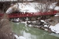
Pedestrian bridge "Asma" in city of Naryn.
Bridges in city of Naryn.
"Having descended the soft clay slope into the valley and crossed the fast Naryn on a wooden bridge, we turned west to the fortress; to the left of the road, at the very foot of the wooded mountain, there was a local hospital in the middle of a large garden, and a little further on a row of white customs buildings was visible."
A.D. Sokolov. "Toguz-Torau." On the new road from Semirechye to Fergana. Verny, 1908.
Residential infrastructure in city of Naryn.
Pedestrian bridge "Asma" is located at an altitude of 2049 meters above sea level, 42 meters below Upper automobile bridge over Naryn River in eastern part of city of same name. The pedestrian bridge connects the right and left banks of the river, symbolically connecting the left-bank central part of the city of Naryn with the Moscow district of the city.
The same can be said about the mountains surrounding the city of Naryn, the bridge connects the eastern spurs of the Alamashik ridge with the southwestern spurs of the Nura ridge. The history of the foundation of Naryn is closely linked to the process of expansion of the Russian Empire in Central Asia.
The city initially developed as a military fortification on a key caravan route connecting the Fergana Valley with Chinese Kashgar. In 1868, a garrison of the Russian army was stationed at this site, which became the starting point for the development of the city.
Over time, the Naryn settlement arose next to the fortification, from which the construction and gradual transformation of the fortification into an urban-type settlement began. A permanent postal service between Semirechye and the Russian consulate in Kashgar passed through Naryn, which emphasized its strategic importance.
Situated on the Naryn River, the city historically served as an important transit point for caravans. Trade routes crossed here and cultural interactions between different peoples took place. This historical context played an important role in the formation of Naryn as a center of trade and contacts in the region.
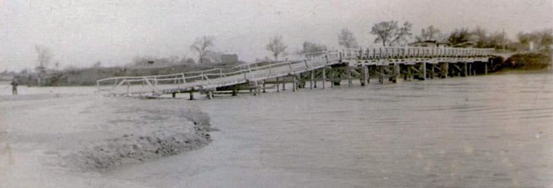
In response to threats from the Kashgar ruler Yakub Bek, the Turkestan Governor-General ordered the construction of a fortification and a bridge across the Naryn River. It should be noted that the first bridge across the Naryn River was built by the Kashgar ruler on the orders of the Kokand Khan, to whom Kashgar was subordinate.
The decision to build a bridge was made to protect caravan routes and ensure control over a strategically important region. In 1867, Colonel V. Poltoratsky, exploring the route to Lake Chatyr-Kul, chose a place to build a fortress. It was located near the Chinese bridge across the Naryn on the caravan road connecting the Chui Valley with Kashgar.
At first, the military built dugouts for temporary housing, then wooden barracks. Two years later, the construction of the fortification was completed, which laid the foundation for the further development of Naryn as a strategic and trade center. In the middle of the XXth century, the wooden pedestrian bridge was rebuilt, replacing wooden structures with metal ones.
The main mode of transport in the Naryn region is automobile. Until the mid-30s of the last century, the only road in the region was a road that connected the village of Kochkor with Naryn. This road was built at the end of the XIXth century. In 2024, a project appeared in the media that envisaged the construction of a glass bridge across the Naryn River in Naryn.
Across the Naryn River, below the Asma pedestrian bridge, there are three more suspension pedestrian bridges. There are two automobile bridges across the Naryn River within the city of the same name - Upper and Lower.
Geographic coordinates of «Asma» pedestrian bridge across Naryn River: N41°25'26 E76°01'11
Authority:
Alexander Petrov.
Photos by:
https://foto.kg/galereya/2674-most-cherez-reku-naryn.html
https://www.smart-guide.org/destinations/ru/naryn/?tour=%D0%9F%D0%B5%D1%88%D0%B8%D0%B9+%D1%82%D1%8