


![]()
You are here
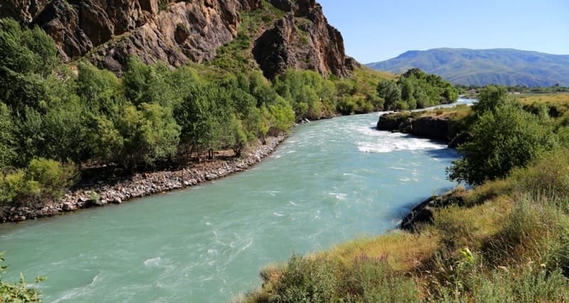
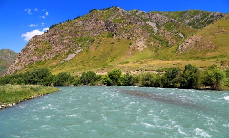
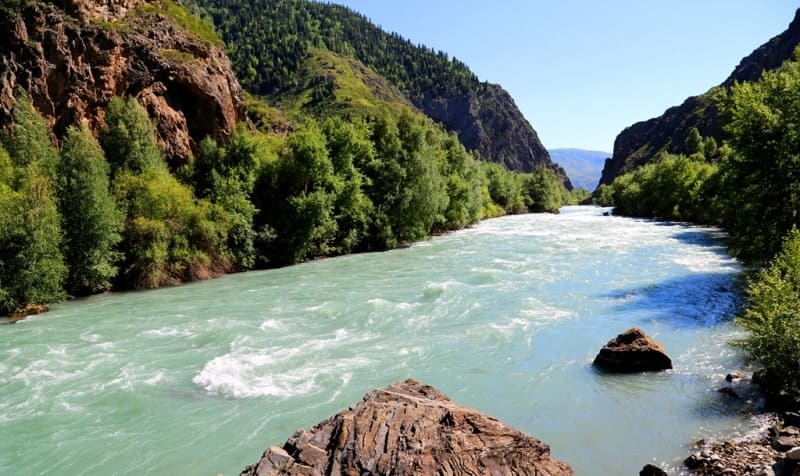
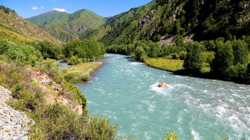
Koksu river in Dzungarsky Alatau.
Adventure travel in Kazakhstan.
“Beauty is a manifestation of secret natural laws, which otherwise would have been hidden from us forever”
Johann Wolfgang von Goethe.
Faith tourism in Kazakhstan.
Koksu River is located at the western end of the Dzhungarsky Alatau ridge, is the left tributary of the Karatal River, flows through the territory of the Kerbulak, Eskeldinsky and Koksu regions of the Almaty region.
The river is formed at an altitude of 1915 m. a. s. l. from the confluence of the Karaaryk and Kazan rivers. The catchment area of the river is 4670 square kilometers. The length of the Koksu River from the confluence of the Karaaryk and Kazan rivers to the mouth of the Karatal River is 159 kilometers.
In the upper reaches, the riverbed is located at the bottom of a narrow intermountain valley, which acquires canyons at the intersections of mountain ranges. They are formed by the spurs of the Toksanbai ridge. The Koksu valley is rocky in the upper part.
The channel is moderately winding, the banks are steep, the height is 0.2 - 0.8 meters, in some places - up to 2 - 4 meters. Floodplain 5 - 10 meters wide. Food snow, glacial. High water in March - September. The depth of the river is from 0.5 to 1.5 meters.
The average annual water flow near the settlement "Koksu" is 37 meters per second. The channel is moderately winding, the banks are steep. Dzungarian Alatau consists of several parallel ranges stretching from the northeast to the southwest and separated by intermountain depressions.
The deepest of the intermountain depressions, through which the Koksu River flows, divides the Dzungarian Alatau into the northern and southern central ranges. The average annual flow of water 46 kilometers from the mouth is about 57 cubic meters per second.
The average slope of the river is 0.004 - 0.005 meters. Behind the village of Baktybay Zholbarysuly, Koksu merges with the Karatal River, which almost doubles the water flow. Passing the foothills with their hilly relief, the river enters the Karatal valley and crosses it in a direction parallel to the channel of the Karatal river to its confluence with the latter.
The catchment area in the middle part is used for settlements and crops and as a pasture, the water in the lower part of Koksu is used for water supply and irrigation. There are bridges at the intersections of the river with roads and railways.
Hydrograph of characteristic water discharges on Koksu River.
The flow of the river is formed mainly due to the melting of glaciers. That is why the maximum water levels in the river are observed in mid-July - the hottest month of summer. In the spring there is also a small flood caused by snowmelt, but, as a rule, it is much weaker than in July.
The maximum flow on the Koksu River takes place in May - July and very rarely at the end of April. The earlier highs are from snowmelt in the catchment area, while the later highs are from glacier melt. During the flood, two types are clearly traced - spring snow and summer - glacial.
n general, these peaks have separate fluctuations of flood waves. There is no summer low water. The low season falls on the month of October. This month the levels are stable. The highest standing of the water level is usually observed during the passage of a snow flood.
Koksu River is characterized by the presence of frequent mudflows - mudflows. The combination of heavy rains, especially warm ones, with spring snowmelt or glacier melt in summer can cause mudflows. Drinking water. In the middle reaches it is used for irrigation of agricultural crops and as a pasture, the water in the lower reaches of the Koksu is used for water supply and irrigation.
The Koksu River flows through the villages (from northwest to southeast): Kanaral, Karatal, Eltai, Baktybay Zholbarysuly, Balbyk bi, Zhastar, Akshatogan, Zhanalyk, Aldabergen, Enbekshikazakh, Mambet, Talapty, Yntymak, Rudnichny, Koksu.
Mouth of Koksu River is located at an altitude of 499 meters above sea level.
Sources of river Koksu.
River Karaaryk.
Karaaryk River is one of the rivers forming Koksu, its length is 50 kilometers. The sources of the river are located at an altitude of 3688 meters above sea level on the southern slope of the Dzungarian Alatau ridge. The main channel of the Karaaryk River is formed at an altitude of 2439 meters above sea level.
From the beginning of the sources to the confluence with the Kazan River - Karaaryk receives 25 large and small tributaries on the right, originating from the southern slopes of the main ridge of the Dzungarian Alatau. On the left, the river receives 22 minor tributaries.
The main left tributary of the river originates from the Karaaryk glacier. The length of the glacier is 1.8 kilometers, the glacier flows down from the eastern slope of the Kongorobo Mountains. The sources of the tributary are located at an altitude of 3305 m. a. s. l.
All left tributaries of the Karaaryk are located in the Kongorobo mountains, which in turn are located in the main range of the Dzungarian Alatau. In the upper reaches of the river there is a moraine, flowing lake Karaaryk at an altitude of 2854 m. a. s. l.
The lake is located in a narrow gorge between the northwestern slope of the Kongorobo mountains and the southeastern slopes of the Dzungarian Alatau ridge. The length of the lake from northwest to southeast is 290 meters. The greatest width in the southern part of the lake is 195 meters.
The area of the lake is 36144 square meters, the perimeter of the lake is 813 meters. The Karaaryk River flows into the northeastern part of the lake with a delta width of up to 120 meters.
Geographic coordinates of Karaaryk River: N44°53'33 E79°46'58
Right tributaries of Karaaryk River.
Nameless, right tributary of Karaaryk River.
After 13.7 kilometers after the sources, on the right, the unnamed, seventh tributary, 10 kilometers long, flows into the Karaaryk. The tributary originates at an altitude of 3835.6 m. a. s. l. The mouth of the nameless tributary is located at an altitude of 2563 m. a. s. l.
Geographical coordinates of nameless, right tributary of Karaaryk River: N44°56'29 E79°49'01
Karasai river.
3.8 kilometers after the nameless tributary, the Karaakyr tributary, 11 kilometers long, flows into the Karaakyr on the right. The main channel of the Karasai is formed from two tributaries at an altitude of 2857 m. a. s. l. The right, western tributary originates from 5 large lakes and 10 small lakes located on the southern slope of the Dzungarian Alatau ridge in the vast Besh-Kol glacial cirque. Lake Besh-Kol 1 is located in the northeastern part of the circus.
The area of the lake is 47853 square meters, the perimeter of the lake is 918 meters. Lake Besh-Kol is located in the northwestern part of the circus. The area of the lake is 85405 square meters, the perimeter of the lake is 1131 meters.
The length of the lake from south to north is 350 meters, the largest width in the central part of the lake is 320 meters.
In the north-eastern part of the circus, there is Lake Lower Karasai. The area of the lake is 61198 square meters, the perimeter of the lake is 1076 meters. The length of the lake from west to east is 418 meters, the largest width in the central part is 190 meters.
Lake Karasai is located in the northern part of the gorge, the eastern tributary. The area of the lake is 58633 square meters, the perimeter of the lake is 977 meters. The length of the lake from south to north is 395 meters, the largest width in the central part of the lake is 177 meters.
The mouth of the Karasai River is located at an altitude of 2449 m. a. s. l.
Geographic coordinates of Karsai River: N44°55'40 E79°46'57
Demekpe river.
5.5 kilometers after the confluence of the Karasai tributary on the right, the Demekpe River, 9.8 kilometers long, flows into the Karaaryk. The main channel of the Demekpe River forms at an altitude of 2933 m. a. s. l. The river receives western and eastern tributaries.
Both tributaries are fed from moraine, flowing lakes. In the upper reaches of the eastern tributary, there is Lake Upper Demekpe, located at an altitude of 3427 m. a. s. l. The area of the lake is 30546 square meters, the perimeter of the lake is 669 meters.
The length of the lake from south to north is 223 meters, the largest width in the northern part of the lake is 156 meters. In the upper reaches of the western tributary of the Demekpe, there is a circus, in which there is a large Demekpe lake.
The area of the lake is 129541 square meters, the perimeter of the lake is 1652 meters.
The length of the lake from southwest to northeast is 620 meters, the largest width in the central part of the lake is 335 meters. In the northeastern part, upstream of the western tributary, there are three small lakes. The upper one is located at an altitude of 3519 meters above sea level, the lower one is at an altitude of 3323 m. a. s. l., there is also a small lake between them.
Mouth of the Demekpe River is located at an altitude of meters above sea level.
Geographical coordinates of Demekpe River: N44°54'34 E79°43'16
Karabulak river.
1.9 kilometers after the tributary of the Demekpe, the Karabulak River, 8.1 kilometers long, flows into Karaaryk from the right. The sources of Karabulak are located on the southern slope of the ridge Dzungarian Alatau at an altitude of 3501 m. a. s. l.
The river has one small tributary on the right and on the left. The mouth of the Karabulak River is located at an altitude of 2272 m. a. s. l.
Geographic coordinates of Karabulak River: N44°53'18 E79°42'31
Karkuldek river.
1.6 kilometers after Karabulak, the tributary Karkuldek, 8.4 kilometers long, flows into Karaaryk from the right. The river receives its main sources from the western tributary, in the upper reaches of the gorge, which has four lakes: Lake South Karkuldek is located at an altitude of 3137 m. a. s. l., Lake Lower Karkuldek is located at an altitude of 3352 m. a. s. l., Lake Middle Karkuldek is located at an altitude of 3453 m. a. s. l., Lake Karkuldek located at an altitude of 3540 m. a. s. l., Lake North Karkuldek located at an altitude of 3336 m. a. s. l.
The main channel of the Karkuldek River is formed at an altitude of 2598 m. a. s. l. The river receives the lowest, left, eastern tributary with a length of 3 kilometers. The remaining 2.4 kilometers, the river flows to the mouth in one channel. The mouth of the Karkuldek River is located at an altitude of 2233 m. a. s. l.
Geographical coordinates of river Karkuldek: N44°52'51 E79°41'03
Korzhun river.
9.6 kilometers after the confluence of the Karkuldek River, the Korzhun River, 19.8 kilometers long, flows to the right. The main channel of the Korzhun River is formed at an altitude of 2407 m. a. s. l. There are three sources in the upper reaches of the river: eastern, two middle and southwestern.
One of the eastern tributaries, 8.2 kilometers long, originates from Lake West Korzhun, located at an altitude of 3433 m. a. s. l. 500 meters northeast of Lake West Korzhun there is another small moraine lake at an altitude of 3486 m. a. s. l.
In the neighboring glacial cirque, located to the west, at an altitude of 3368 meters above sea level, there is Lake Korzhun, the sources of which fill the Korzhun River. T
o the west, on the southern slope of the Dzungarian Alatau, there are two more glacial cirques with small moraine lakes. On average, in the westernmost gorge of the upper Korzhun, there is a nameless, oval lake located on the moraine part of the glacier, at an altitude of 3439 m. a. s. l.
The length of the lake from southwest to northeast is 345 meters, the width in the central part is 325 meters. There are two small glaciers in this circus. The southernmost of them, in its northeastern part, borders on the western shore of a nameless lake.
From the extreme southwestern gorge, a tributary of Korzhun flows 9.8 kilometers long, which flows to the mouth of the Ayusay River. In the upper reaches of this gorge there is an unnamed peak with a height of 4057.3 m. a. s. l. On the eastern, watershed slope of the gorge, there is a nameless glacier 1.6 kilometers long.
In the neighboring, more western gorge, there is the Altynsarin glacier, 1.2 kilometers long, belonging to the basin of the Kora River. Down the gorge, on the northern slopes, there are 5 small glaciers. One of them, the longest, its length is 1.9 kilometers.
The sources of the glacier are located at an altitude of 3784 m. a. s. l. The tongue of the glacier is located at an altitude of 2932 m. a. s. l. The mouth of the Korzhun River is located at an altitude of 2076 m. a. s. l.
Geographical coordinates of lake on average, in westernmost gorge of upper reaches of Korzhun River: N44°56'40 E79°30'43
Geographic coordinates of Korzhun River: N44°51'24 E79°35'53
Ayusay river.
After 11.7 kilometers after the sources of the Korzhun River, the Ayusai tributary, 11 kilometers long, flows into the river on the right. The sources of the Ayusay River begin from the lake of the same name at an altitude of 3120 m. a. s. l. In the west and north-west of Lake Ayusay there is a glacier of the same name, which has two branches: northern and southern.
The northern branch of the Ayusay glacier is 1.7 kilometers long. The area of the glacier is 1.05 square kilometers, the perimeter is 5.34 kilometers. The sources of the northern part of the glacier are located at an altitude of 3820 m. a. s. l.
The tongue of the glacier is in contact with the lake.
The southern branch of the Ayusai glacier, 1.4 kilometers long in its eastern part, also breaks into the lake. The area of the glacier is 0.84 square kilometers, the perimeter is 4.18 kilometers..The sources of the southern branch of the glacier are located at an altitude of 3607 m. a. s. l.
Ayusay River has a wide catchment area. In the northernmost branch of the gorge there are 4 small moraine lakes located at an altitude of 3309 and 3266 m. a. s. l. Between this gorge and Lake Ayusay there is a small glacial cirque with a moraine lake located at an altitude of 3412 m. a. s. l.
The main channel of the Ayusay River is formed at an altitude of 2792.4 meters above sea level.
The mouth of the Ayusay River is located at an altitude of 2328 m. a. s. l.
Geographical coordinates of Ayusai River: N44°51'52 E79°32'11
For almost 26 kilometers between the mouth of the Korzhun and the tributary of the Arasan, 11 nameless, small tributaries flow into the Karaaryk on the right and only one tributary flows into the Koksu River.
Kebegeli river.
9 kilometers after the left tributary of the Kazan flows into the Karaaryk River, after which the Koksu River is formed, a small tributary of the Kebegeli, 6.7 kilometers long, flows to the right. The mouth of the Kebezheli River is located at an altitude of 1850 meters above sea level.
Geographic coordinates of Kebezheli River: N44°46'00 E79°24'03
Right tributaries of Koksu River.
Arasan river.
25 kilometers after the confluence of the Korzhun River, on the right into the Koksu, the Arasan tributary flows 25.6 kilometers long. The western sources of the Arasan River are located at an altitude of 3413 and 3537 m. a. s. l. in the watershed range between the main channel and the right tributaries of the Ayusay.
The eastern source of Arasan is located on the southern slope of the Kumbel pass, 3124 m. a. s. l. The main channel of Arasan is formed at an altitude of 2709 m. a. s. l. After the Kimal-Kurgan burial ground located on the left bank, at an altitude of 2414 m. a. s. l., 15 tributaries flow into the Arasan River from the right side.
All left tributaries are filled from springs located on the southern slopes of the gorge in the tracts of Mynzhylky and Arasan. On the opposite bank of the Arasan River there are tracts: Kebegeli, Shemuldyk-Karagay and not far from the mouth of Zhambas.
There is a small cave in the eastern part of the Shemuldyk-Karagai valley and to the north of the Kebegli valley. In the Arasan valley, on the right bank, there is a mineral spring of the same name at an altitude of 2209 m. a. s. l. 1.8 kilometers southeast of the Kimal-Kurgan burial ground is the Air-Kezen pass, 2751.4 m. a. s. l.
The mouth of the Arasan River is located at an altitude of 1838 m. a. s. l.
Geographic coordinates of Arasan River: N44°46'28 E79°21'57
Kutyrgan-Bulak river.
Between the tracts of Arasan and Mynzhylki, 8 kilometers to the mouth, on the right, a tributary of Kutyrgan-Bulak, 7.8 kilometers long, flows into the Arasan River. The sources of the river are located in the eastern part of the Arasan mountains, on the southern slope of the Dzungarian Alatau ridge.
At an altitude of 3216 meters above sea level, the river of the same name originates from Lake Kutyrgan-Bulak. From Zhasyl-Kol Lake, located at an altitude of 2484 meters above sea level on the southern slope of the Arasan Gorge, a 2.6-kilometer-long river flows out, which flows into the Kutyrgan-Bulak River on the left.
Geographical coordinates of Kutyrgan-Bulak River: N44°48'37 E79°24'57
Takyr river.
5.3 kilometers before the mouth of the Arasan River, the Takyr River, 7 kilometers long, flows in from the right. The river originates in the Takyr natural landmark, on the southern slope of the Arasan Mountains at an altitude of 3272.6 m. a. s. l. Takyr has 7 left tributaries, all of them are of spring origin.
The mouth of the Takyr River is located at an altitude of 2052 m. a. s. l.
Geographic coordinates of Takyr River: N44°48'50 E79°21'49
River Tentek-Say.
5.6 kilometers after the Arasan tributary flows into the Koksu River, the Tentek-Sai tributary, 19.5 kilometers long, flows to the right. The sources of the river are located at an altitude of 3919.7 m. a. s. l. on the northern slopes of the Arasan mountains in the Dzungarian Alatau ridge.
The river receives its main sources from glaciers located on the southern slope of the Dzungarian Alatau ridge. The main channel of the Tentek-Sai River is formed at an altitude of 2692 m. a. s. l. from two tributaries - eastern and western.
In the upper reaches of the eastern sources of the river, in narrow gorges, there are 5 small glaciers.
The largest of them, in the eastern part of the gorge, is the Tentek-Sai glacier with a length of 2.9 kilometers. The area of the glacier is 1413095 square meters, the perimeter is 6892 meters. In the lower part of the glacier there are 3 moraine lakes at an altitude of 3182 m. a. s. l.
One lake is located in the western part of the tongue of the glacier at an altitude of 3303 m. a. s. l. In the upper reaches of the western tributary, there are 5 moraine lakes. Among them, at an altitude of 3448 meters above sea level, there is Lake Tentek-Sai. After the formation of the main channel, the river receives 5 tributaries on the right.
The mouth of the Tentek-Sai River is located at an altitude of 1766 m. a. s. l.
Geographic coordinates of Tentek-Say River: N44°47'02 E79°18'00
River Kotyrgan-Bulak Western.
After 10.4 kilometers from the beginning of the sources, the Kotyrgan-Bulak Western tributary, 6.4 kilometers long, flows into the Tentek-Sai River on the right. The sources of the river are located on the southern slope of the Dzungarian Alatau ridge, at an altitude of 3510 m. a. s. l.
The mouth of the Kotyrgan-Bulak West River is located at an altitude of 2422 m. a. a. s. l.
Geographic coordinates of Kotyrgan-Bulak River: N44°50'10 E79°18'23
Tersakkan river.
5.5 kilometers after the confluence of the Kotyrgan-Bulak Western tributary into the Tentek-Sai, the Tersakkan tributary, 7.2 kilometers long, flows to the right. The river on the left receives 5 tributaries. The sources of the river are located on the southern slopes of the Tiliktor mountains, at an altitude of 2393 m. a. s. l.
400 meters before the mouth of the Tersakkan River, in the narrowing of the gorge, there is a small waterfall. The mouth of the Tersakkan River is located at an altitude of 2025 m. a. s. l.
Geographic coordinates of Tersakkan River: N44°48'28 E79°16'29
Orta-Karasay river.
4.8 kilometers after the sources, the tributary Orta-Karasai, 4.4 kilometers long, flows into Tersakkan on the left. The sources of the river are located northeast of the Tiliktor mountains, on the southern slope of the Koksu gorge. The mouth of the Orta-Karasay River is located at an altitude of 2186 m. a. s. l.
Geographical coordinates of Orta-Karasay River: N44°49'01 E79°17'02
Birinshi-Karasai river.
After 5.7 kilometers after the sources, the tributary Birinshi-Karasai, 6.5 kilometers long, flows into Tersakkan from the left. The sources of the river are located northeast of the Tiliktor mountains on the southern slope of the Koksu gorge. The mouth of the Birinshi-Karasay River is located at an altitude of 2154 meters above sea level.
Geographic coordinates of Birinshi-Karasai River: N44°48'54 E79°17'35
Sandyktas river.
2.6 kilometers after the confluence of the Tentek-Sai river into the Koksa, a tributary of Sandyktas 5.5 kilometers long flows into the right. The sources of the river are located in the Sandyk mountains on the southern slope of the Koksu gorge. The mouth of the Sandyktas River is located at an altitude of 1716 m. a. s. l.
Geographic coordinates of Sandyktas River: N44°45'52 E79°15'10
Sandyk river.
3.3 kilometers after the confluence of the Sandyktas tributary into the Koksu River, the Sandyk tributary, 9 kilometers long, flows to the right. The sources of the Sandyk River are located in the mountains of the same name at an altitude of 2614.9 m. a. s. l.
The Sandyk Mountains are the watershed between the Koksu River and Shymbulak. The mouth of the Sandyk River is located at an altitude of 1658 m. a. s. l.
Geographic coordinates of Sandyk River: N44°46'28 E79°12'46
For 13.3 kilometers after the mouth of the Sandyk River, 5 small tributaries flow into Koksu on the right. Koksu flows through the Taban natural landmark located on the right bank. The southern slopes of the Koksu gorge are located in the Koktobe mountains.
From the Taban valley, the Zhanbas trail begins, which after 20 kilometers leads to the vicinity of the town of Tekeli. The trail passes the Arshaly valley, the Shertybay ridge.
River Tesiksay.
13.3 kilometers after the confluence of the Sandyk tributary into the Koksu River, the Tesiksai River, 6.6 kilometers long, flows from the right. The sources of the Tesiksai River are located in the Arshaly natural landmark, to the east of Mount Aktobe, 2732.3 m. a. s. l.
To the west of Mount Aktobe is the Uzynzhota tract. The mouth of the Tesiksay River is located at an altitude of 1492 m. a. s. l. The river is fed by numerous springs.
Geographical coordinates of Tesiksay River: N44°45'12 E79°04'39
From the mouth of the Tesiksay to the confluence of the Kaiynda River, 17 tributaries flow into the Koksu on the right.
Kayindy river.
39 kilometers after the confluence of the Tesiksaya River into the Koksu, a tributary of the Kaiynda with a length of 16.7 kilometers flows from the right. The sources of the river are located southeast of the Mynbulak tract at an altitude of 2677.7 m. a. s. l.
In the upper reaches, the river flows through the Sholzhota natutral landmark. In the middle reaches, the river crosses the road: the settlement of Rudnichny - the settlement of Zhalgyzagash. The river is fed by numerous springs. The mouth of the Kaiynda River is located at an altitude of 1062 m. a. s. l.
Geographical coordinates of Kaiyndy River: N44°42'55 E78°42'51
Zhalgyzagash river.
45.6 kilometers after the confluence of the Kaiynda River, the Zhalgyzagash River, 43 kilometers long, flows to the right. The sources of the river originate in the tract Aktasty and Mynbulak from numerous springs. The main channel of the Zhazylagash River is formed at an altitude of 867 m. a. s. l. in the village of Zhalgyzagash.
One of the highest sources of the river is located in the south west of Mount Suyktobe, 2752.8 m. a. s. l. In the upper course, the river is called Zhalgyz. The river receives 15 small tributaries to the right of the source and to the mouth, and 11 tributaries to the left. In the middle reaches, the river flows through the Sarynogai tract, which is a watershed with the Kusak River.
The mouth of the Zhalgyzagash River is located in the northeast of the village of Talapty, at an altitude of 724 m. a. s. l. To the south and east of the village of Bigash, a tributary of the Terekty flows into Zhalgyzagash. In turn, the Small Terekty and Bolshoi Terekty rivers flow into the Terekty River. T
o the south, Zhalyndy and Kyzylbastau flow into the Bolshoi Terekty River. At the confluence of the Zhylandy and Kyzylbastau rivers, the Bolshaya Terekty River is formed.
Geographic coordinates of Zhalgyzagash River: N44°46'41 E78°29'12
Small Terekty river.
Small Terekty River, 15.2 kilometers long, flows into the Bolshaya Terekty River south of the village of Bigash. The sources of the river are located to the west of the Mynbulak tract at an altitude of 2235.7 m. a. s. l. The river is fed by numerous springs.
The mouth of the Small Terekty River is located at an altitude of 862 m. a. s. l.
Geographical coordinates of Small Terekty River: N44°44'27 E78°39'18
Bolshaya Terekty river.
Bolshaya Terekty River, 18.5 kilometers long, begins its sources in the Mynbulak tract, at an altitude of 2235.7 meters above sea level. 2.7 kilometers before the village of Bigash, on the right bank of the Bolshaya Terekta River, there are rock paintings. The river is fed by numerous springs.
Geographical coordinates of Bolshaya Terekty River: N44°43'42 E78°38'07
Zhylandy river.
Zhylandy River, 10.8 kilometers long, originates in the Sholzhota tract at an altitude of 1985.8 meters above sea level. The river is fed by numerous springs. The mouth of the Zhylanda River is located at an altitude of 925 m. a. s. l., 1.1 kilometers southwest of the settlement of Bigash.
Geographic coordinates of Zhylandy River: N44°42'06 E78°37'34
Kyzylbastau river.
Kyzylbastau River, 10.2 kilometers long, originates on the northern slopes of the Kyzyl-Kungei Mountains at an altitude of 1609 m. a. s. l. The river is fed by numerous springs. The mouth of the Kyzylbastau River is located at an altitude of 925 m. a. s. l., 1.1 kilometers southwest of the village of Bigash.
Geographical coordinates of Kyzylbastau River: N44°41'20 E78°36'04
Ashchybulak river.
1.8 kilometers after the confluence of the Zhalgyzagash, the Ashchibulak River, 26.2 kilometers long, flows into Koksa from the right. The sources of the river are located south of the Kusak tract and west of the Sarynogay tract at an altitude of 1294.2 meters above sea level.
For 16 kilometers the river flows along the southern slopes of the Eshkiolmes mountains. There are a large number of rock paintings in the Eshkiolmes mountains. The mouth of the Ashchybulak River is located at an altitude of 713 meters above sea level.
Geographic coordinates of Ashchybulak River: N44°50'14 E78°31'31
Sources of river Koksu.
Kazan river.
Kazan River is the left tributary of the Karaaryk River, resulting in the formation of the Koksu River. The length of the Kazan River is 47.7 kilometers. The main channel of the Kazan River is formed at an altitude of 2491 m. a. s. l. from the confluence of the right tributary of the Dzheldysay (Borotal).
The length of the Kazan River from its source to the mouth with Jeldysay is 17 kilometers. From the beginning of the sources to the mouth of the Kazan, the river receives 43 tributaries on the left, 10 of them are large. On the right, the river receives 11 tributaries, 3 of them are large.
In the upper reaches of the Kazan River, there is a glacier of the same name. Kazan Glacier is divided into two branches: East and West. The upper limit of the Eastern branch of the glacier is located at an altitude of 3951 to 4082 m. a. s. l.
The tongue of the glacier is located at an altitude of 3382 m. a. s. l., the river of the same name flows from its northern part.
The area of the Eastern branch of the Kazan glacier is 2353943 square meters, the perimeter is 7013 meters. The length of the glacier is 3.6 kilometers. Along the eastern branch of the Kazan glacier, along the eastern ridge of the Dzungarian Alatau ridge, the state border between the Republic of Kazakhstan and the Republic of China passes.
The upper limit of the Western branch of the Kazan glacier is located at an altitude of 3969 m. a. s. l. The tongue of the Western Kazan glacier is located at an altitude of 3319 m. a. s. l., one of the upper tributaries of the Kazan River flows from its northwestern part.
The area of the Western branch of the Kazan glacier is 2520631 square meters, the perimeter is 6095 meters. The length of the glacier is 1.9 kilometers. The area of the closed part of the Western Kazan glacier is 1004303 square meters. In the upper reaches of the glacier, in the main crest of the ridge
Kazan is 1004303 square meters. In the upper reaches of the glacier, in the main ridge of the Dzungarian Alatau ridge, there is the Kobyltau peak, 3900.1 m. a. s. l. In the northeastern part of the upper reaches of the Kazan River, in the Dzungarian Alatau ridge, there are the Kongorobo Mountains.
The border mountains of Kongorobo stretch from southeast to northwest for 7 kilometers. At 4.4 kilometers from the mouth of the river Dzheldysay (Borotala) in the eastern part is Mount Kyzuya, 3077.1 m. a. s. l., which is the watershed between the rivers Dzheldysay and Kazan.
Geographical coordinates of Kazan River: N44°48'06 E79°42'03
River Karkuldek Ontustik.
After 8.3 kilometers from the beginning of the sources, the Karkuldek Ontustik River, 6.3 kilometers long, flows into the Kazan River on the left. In the upper reaches, the river is formed into the main channel at an altitude of 2974 m. a. s. l. from two tributaries: eastern and western.
At the headwaters of the western tributary, in the upper reaches of the gorge, there is a moraine, flowing lake Karkuldek Ontustik at an altitude of 3250 m. a. s. l; A stream flows out of the northwestern end of the lake. The mouth of the river is located at an altitude of 2726 m. a. s. l.
Geographic coordinates of river Karkuldek Ontustik: N44°49'32 E79°54'05
Sarkrama river.
After 10.8 kilometers from the beginning of the sources, the Sarkrama River, 5.4 kilometers long, flows into the Kazan River on the left. The gorge of the Sarkram River is located on the northern slope of the Toksanbay ridge, in the southwestern part of the Dzungarian Alatau ridge.
The main channel of the river is formed at an altitude of 2949 m. a. s. l. from several tributaries. The sources of the river begin from the Sarkrama glacier, located in the upper reaches of the gorge of the same name, 1.1 kilometers long. The upper limit of the glacier is located at an altitude of 3674 m. a. s. l.
The tongue of the Sarkrama Glacier is located at an altitude of 3307 m. a. s. l. The area of the glacier is 806657 square meters, the perimeter is 4538 meters. 530 meters northwest of the glacier is a small moraine lake, located at an altitude of 3221 m. a. s. l.
The mouth of the Sarkrama River is located at an altitude of 2625 m. a. s. l.
Geographic coordinates of Sarkrama River: N44°49'22 E79°51'45
Kokoay River.
After 14 kilometers from the beginning of the sources into the Kazan River and 3.2 kilometers after the confluence of the Sarkrama River, on the left, the Kokoai River, 6.9 kilometers long, flows into the Kazan. The main course of the Kokoay River is formed at an altitude of 2560 m. a. s. l. from several tributaries.
The source of the river begins with the tongue of the Kokcoay glacier located at an altitude of 3288 meters above sea level. The glacier consists of two branches: Western and Eastern. The length of the Western branch of the Kokoay Glacier is 1.4 kilometers.
The area of the glacier is 693289 square meters, the perimeter is 3653 meters. The upper limit of the Kokoay Glacier is located at an altitude of 3402 m. a. s. l. The tongue of the West Kokoay Glacier is located at an altitude of 3288 m. a. s. l.
The length of the Eastern Branch of the Kokoay Glacier is 1.4 kilometers.
The area of the glacier is 761872 square meters, the perimeter is 4382 meters. The upper limit of the Kokoay Glacier is located at an altitude of 3790 m. a. s. l. The tongue of the West Kokoay Glacier is located at an altitude of 3275 m. a. s. l. The mouth of the Kokoay River is located at an altitude of 2558 m. a. s. l.
In the middle reaches of the river, in the valley, there are numerous moraine lakes located at an altitude of 3275 m. a. s. l.
Geographic coordinates of Kokoay River: N44°49'35 E79°50'17
Archaly river.
8 kilometers after the Sarkrama tributary flows into the Kazan River, the Archaly tributary, 5.8 kilometers long, flows to the left. The sources of the Archaly River are located on the northern slope of the Kazan Gorge at an altitude of 3538 meters above sea level. The mouth of the Archaly River is located at an altitude of 2428 m. a. s. l.
Geographical coordinates of Archaly River: N44°49'42 E79°47'55
Tentyk-Bulak river.
3.2 kilometers after the confluence of the Archaly River into the Kazan, a tributary of the Tentyk-Bulak with a length of 7.9 kilometers flows from the left. The main channel of the Tentyk-Bulak River is formed at an altitude of 2583 m. a. s. l. from two tributaries: eastern and western.
The eastern tributary originates from two moraine, flowing lakes: Tentyk-Bulak Shygys and Tentyk-Bulak.
Geographic coordinates of Tentyk-Bulak River: N44°48'53 E79°46'00
Moraine, flowing lake Tentyk-Bulak Shygys
Is located at an altitude of 3381 m. a. s. l. The length of the lake from southeast to northwest is 395 meters, the largest width in the central part is 175 meters. The area of the lake is 48181 square meters, the perimeter is 1015 meters. Above the lake, on the northern slope of the ice cirque, there is a small glacier 750 meters long.
The upper limit of the glacier is located at an altitude of 3694 m. a. s. l. The tongue of the glacier is located at an altitude of 3397 m. a. s. l.
Moraine, flowing lake Tentyk-Bulak
Is located at an altitude of 3174 m. a. s. l. The length of the lake from southwest to northeast is 358 meters, the largest width in the eastern part is 256 meters. The area of the lake is 23766 square meters, the perimeter is 692 meters. In the southern part of the lake there is a glacier with a length of 1.6 kilometers.
The upper limit of the glacier is located at an altitude of 3788 m. a. s. l. The tongue of the glacier is located at an altitude of 3252 meters above the level. The area of the glacier is 1.23 square kilometers, the perimeter is 4.64 kilometers.
The western tributary, 5 kilometers long, originates from the Shygys Tentyk-Bulak glacier.
The upper border of the glacier is located at 3768 and 3790 m. a. s. l. The tongue of the Shygys Tentyk-Bulak glacier is located at an altitude of 3299 m. a. s. l. The length of the glacier is 1.7 kilometers. The area of the glacier is 1.61 square kilometers, the perimeter is 6.1 kilometers.
The mouth of the Tentyk-Bulak River is located at an altitude of 2369 m. a. s. l.
Geographic coordinates of Tentyk-Bulak River: N44°48'53 E79°46'00
Akaiyr river.
1150 meters after the confluence of the Tentyk-Bulak River, the Akaiyr River, 5.2 kilometers long, flows into the Kazan from the left. The sources of the river are located at an altitude of 3592 m. a. s. l. in the watershed ridge with the basin of the river Usek.
The mouth of the Akaiyr River is located at an altitude of 2352 m. a. s. l.
Geographic coordinates of Akaiyr River: N44°48'12 E79°44'54
River Kutyrgan-Bulak Ontustik.
2.9 kilometers after the confluence of the Akaiyr tributary, the Kutyrgan-Bulak Ontustik River, 7.6 kilometers long, will flow into Kazan from the left. The main channel of the Kutyrgan-Bulak Ontustik River is located at an altitude of 2991 m. a. s. l.
It is formed from two tributaries:
Shygys and Batys Kutyrgan-Bulak.
In the upper reaches, a tributary of the Shygys Kuturgan-Bulak, there is a lake of the same name at an altitude of 3178 m. a. s. l. The length of the lake from west to east is 238 meters, the largest width in the central part of the lake is 180 meters.
The area of the lake is 34947 square meters, the perimeter is 811 meters. In the upper reaches of the lake there is a glacier with a length of 1.3 kilometers. The area of the glacier is 1.04 square kilometers, the perimeter is 4.51 kilometers.
The upper limit of the glacier is located at an altitude of 3731 m. a. s. l.
The tongue of the glacier is located at an altitude of 3282 m. a. s. l. In the upper reaches of the tributary Batys Kuturgan-Bulak, there is a lake of the same name at an altitude of 3246 m. a. s. l. The length of the lake from southwest to northeast is 224 meters, the largest width in the central part of the lake is 67 meters.
The area of the lake is 11944 square meters, the perimeter is 504 meters. In the upper reaches of the lake there is a glacier with a length of 1.3 kilometers. The area of the glacier is 626013 square meters, the perimeter is 3570 meters. The upper limit of the glacier is located at an altitude of 3809 m. a. s. l.The tongue of the glacier is located at an altitude of 3246 m. a. s. l.. The mouth of the Kutyrgan-Bulak Ontustik River is located at an altitude of 2311 m. a. s. l.
Geographical coordinates of river Ontustik Kutyrgan-Bulak: N44°46'34 E79°43'26
Kara-Bulak river.
2.4 kilometers after the confluence of the Ontustik Kutyrgan-Bulak tributary into the Kazan River, the Kara-Bulak tributary, 10.3 kilometers long, flows to the left. The main channel of the Kara-Bulak river. formed at an altitude of 2417 m. a. s. l.
In the upper reaches of the river there is a glacier Kara-Bulak consisting of two branches.
The western branch of the glacier is 1.72 square kilometers, the perimeter is 7.65 kilometers. The length of the glacier is 1.4 kilometers. The upper limit of the glacier is located at an altitude of 3857 meters above sea level. The tongue of the glacier is located at an altitude of 3298 m. a. s. l.
The length of the eastern branch of the glacier is 1.84 kilometers. The area of the glacier is 2.24 kilometers, the perimeter is 8.3 kilometers. The upper limit of the glacier is located at an altitude of 4023 m. a. s. l. The tongue of the glacier is located at an altitude of 3194 meters above sea level. The mouth of the Kara-Bulak River is located at an altitude of 2270 m. a. s. l.
Geographic coordinates of Kara-Bulak River: N44°46'14 E79°41'44
Kyzkurgan river.
8.8 kilometers after the confluence of the Kara-Bulak tributary into the Kazan River, the Kyzkurgan tributary, 5.1 kilometers long, flows to the left. The river originates from a small moraine lake located at an altitude of 3160 m. a. s. l. In the upper reaches of the river there is a small glacier, consisting of several branches.
The mouth of the Kyzkurgan River is located at an altitude of 2133 m. a. s. l. At 3.4 kilometers to the east from the mouth of the Kyzkurgan River, a forest zone begins, located at an altitude of 2339 m. a. s. l.
Geographical coordinates of Kyzkurgan River: N44°44'57 E79°36'11
Kokkiya river.
3.4 kilometers after the confluence of the Kyzkurgan tributary into the Kazan River, the Kokkiya tributary, 6.6 kilometers long, flows to the left. The main channel of Kokkiya is located at an altitude of 2025 m. a. s. l. In the upper reaches of the river there are two tributaries that form the main channel: eastern and western. In the upper reaches of the eastern source of the Kokkiya River, located at an altitude of 3646 m. a. s. l., there is a glacier with a length of 1 kilometer.
The upper limit of the glacier is located at an altitude of 3646 meters above sea level.
The tongue of the glacier is located at an altitude of 3270 m. a. s. l. In the upper reaches of the western source there is a small glacier, also 1 kilometer long. The upper limit of the glacier is located at an altitude of 3881 meters above sea level.
The tongue of the glacier is located at an altitude of 3208 m. a. s. l. The mouth of the Kokkiya River is located at an altitude of 2090 m. a. s. l.
Geographical coordinates of river Kokkiya: N44°44'15 E79°33'04
Kyzyl-Sai river.
5.5 kilometers after the confluence of the Kokkiya tributary into the Kazan River, the Kyzyl-Sai tributary, 5 kilometers long, flows to the left. The sources of the river are from two moraine lakes located at an altitude of 3177 (western tributary) and 3347 (eastern tributary) m. a. s. l.
In the upper reaches of the western tributary there is a 1.1 km long glacier. The upper border of the glacier is located at an altitude of 3924 m. a. s. l. in the crest of the Toksanbay ridge. The tongue of the glacier is located at an altitude of 3177 m. a. s. l. The mouth of the Kyzyl-Sai River is located at an altitude of 1983 me. a. s. l.
Geographical coordinates of Kyzyl-Sai River: N44°44'07 E79°30'16
Left tributaries of Koksu River.
Satyly river.
After 1.6 kilometers, the Kazan River flows into Koksa, and after 6.9 kilometers from the left, the Satyly River, 5.5 kilometers long, flows into Koksa. The Satyly River originates from the northern slope of the Satyly Pass at a height of 2796 m. a. s. l.
The pass is a watershed between the basins of the Koktal and Koksu rivers. The mouth of the Satyly River is located at an altitude of 1868 m. a. s. l.
Geographical coordinates of Satyly River: N44°44'09 E79°23'20
Koksay river.
16.5 kilometers after the Satyly River flows into the Koksu River, a low-water tributary of the Koksay, 10.7 kilometers long, flows from the left. The sources of Koksay are located at an altitude of 3210.6 m. a. s. l. The sources of the river are located to the east of the Kyskabulak and Koayandy mountains, which are the most southwestern spurs of the Dzungarian Alatau ridge.
The mouth of the Koksay River is located at an altitude of 1672 m. a. s.. l.
Geographic coordinates of Koksay River: N44°42'55 E79°16'07
Ermenesai river.
320 meters before the confluence of the Koksay River into the Koksu River, on the right, a shallow tributary of the Ermenesai, 13.4 kilometers long, flows into the Koksay. The sources of the river begin at an altitude of 3230 m. a. s. l. in the western part of the Toksanbay ridge in the southwestern spurs of the Dzhungar Alatau. The mouth of the Ermenesai River is located at an altitude of 1676 m. a. s. l.
Geographic coordinates of Ermenesai River: N44°44'13 N44°44'13
River Kamennaya.
3.4 kilometers after the Koksay river flows into Koksa, the Kamennaya tributary, 7.3 kilometers long, flows from the left. The sources of the river are located at an altitude of 3072 m. a. s. l. from a moraine, flowing lake Kamennoye. Lake Stone is located on the northern slope of the Kyskabulak mountains, which are the southwestern spurs of the Dzungarian Alatau ridge.
The area of the lake is 26307 square meters, the perimeter is 593 meters. The length of the lake is 173 meters, the width of the lake in the central part is 170 meters. The lake is located in a characteristic glacial cirque. A stream flows out of the northwestern part of the lake through underground channels.
At an altitude of 2732 m. a. s. l., the main channel of the river is formed. The mouth of the Kamennaya River is located at an altitude of 1633 m. a. s. l.
Geographical coordinates of Kamennaya River: N44°44'20 E79°11'13
Koktal river.
31.6 kilometers after the confluence of the Kamennaya River into the Koksa, the complex tributary Koktal with a length of 36.1 kilometers flows from the left. The main channel of the Koktal River is formed at an altitude of 1869 m. a. s. l. from the confluence of the left tributary Aksai into the Satyly River.
At 14 km after the start, on the left bank of the river, there is the village of Aral located at an altitude of 1497 m. a. s. l. At 23.5 kilometers on the river there is a road bridge on the road Shubar - Rudnichny. From the beginning of its sources, the Koktal River on the right has 14 tributaries, 4 of which are large.
There are no tributaries to the left, with the exception of irrigation canals that depart from the left bank of the Koktal River and flow into the lower reaches of the Keskenterek River. The mouth of the Koktal River is located at an altitude of 1211 m. a. s. l.
Geographic coordinates of Koktal River: N44°35'32 E78°59'42
Satyly river.
Satyly River, 30.9 kilometers long, originates in the western spurs of the Toksanbai Range at an altitude of 3924 m. a. s. l. On the right, the river receives three small, not significant tributaries. On the left, the river receives six tributaries, two of which are full-flowing.
The sources of the river are located in a narrow gorge, in the upper reaches of which, on the slope of the northern exposure, there is a small glacier, consisting of several branches. Almost for 5 kilometers in the upper part of the gorge there is a moraine. At an altitude of 1869 m. a. s. l., the Aksai River flows to the left.
Geographical coordinates of Satyly River: N44°38'33 E79°18'42
River Orakty.
At the 16th kilometer after the sources of the Satyly River, a small Orakty River, 5 kilometers long, flows in from the right. The sources of the river begin in the western spurs of the Toksanbay ridge at an altitude of 2335 m. a. s. l. The mouth of the Orakta River is located at an altitude of 2391 m. a. s. l.
Geographical coordinates of Orakty River: N44°40'44 E79°22'34
Maly Satyly river.
At 18.2 kilometers after the sources of the Satyly River, a tributary of the Maly Satyly, 10.8 kilometers long, flows in from the left. The main channel of the Maly Satyly River is formed at a height of . 2714 m. a. s. l. from two tributaries: northern and southern.
The sources of the southern source are located at an altitude of 3636 m. a. s. l. in the upper reaches of the river of the same name. Here is a small glacier with an area of 1.99 square kilometers, its perimeter is 7.92 kilometers. The tongue of the glacier is located at an altitude of 3240 m. a. s. l.
The tongue of the moraine of the glacier is located at an altitude of 3045 m. a. s. l. The mouth of the Maly Satyly River is located at an altitude of 2311 m. a. s. l.
Geographical coordinates of Maly Satyly River: N44°39'01 E79°23'59
Aksai river.
Aksai River, 12.5 kilometers long, flows into the Satali River at an altitude of 1869 m. a. s. l. After this tributary, the Koktal River is formed. The main channel of the Aksai River is formed from two tributaries at an altitude of 2603 m. a. s. l: northern and southern.
The sources of the southern tributary are at an altitude of 3345 m. a. s. l. The sources of the northern tributary with a length of 4.7 kilometers (before the beginning of the main channel of the river) are located at an altitude of 3627 m. a. s. l. The mouth of the Aksai River is located at an altitude of 1869 m. a. s. l.
Geographical coordinates of Aksai River: N44°36'58 E79°18'51
Taiosa River.
3.3 kilometers after the beginning of the Koktal River, the Taiouza River, 11.7 kilometers long, flows in from the right. The sources of the river are located to the east of the Koyandy mountains at an altitude of 3000 and 3496 m. a. s. l. To the west of the middle riverbed is the dominant height of the Koyandy Mountains - the peak of the same name, 3600 m. a. s. l.
The mouth of the Tayouza River is located at an altitude of 1784 m. a. s. l.
Geographical coordinates of Tayouza River: N44°37'57 E79°14'02
Koyandy river.
12.2 kilometers after the confluence of the Taiouz River into the Koktal, a tributary of the Koyandy with a length of 13.7 kilometers flows from the right. The sources of the river are located on the southern slopes of the Koyandy mountains at an altitude of 3321 m. a. s. l.
The mouth of the Koyandy River is located at an altitude of 1458 m. a. s. l. in the northwestern part of the Aral village.
Geographical coordinates of Koyandy River: N44°37'23 E79°07'35
tasty river.
17 kilometers after the confluence of the Koyandy River, a low-water and extended tributary of the Aktasty, 16.3 kilometers long, flows into the Koktal on the right. The sources of the river are located in the mountains of Koyandy at an altitude of 3205 m. a. s. l.
The mouth of the Aktas River is located at an altitude of 1245 m. a. s. l.
Geographic coordinates of Aktasty River: N44°37'38 E79°03'37
Kosagash river.
The Kosagash River, 14.8 kilometers long, flows into the right-bank wide, floodplain part of the Koktal River. The sources of the river are located in the mountains of Koyandy at an altitude of 2991 meters above sea level. The mouth of the river is located at an altitude of 1245 m. a. s. l.
Geographic coordinates of Kosagash River: N44°38'03. E79°01'17
Keskenterek river.
At 29.4 kilometers after the beginning of the sources of the Koktal River, the Keskenterek River, 51 kilometers long, flows from the left. The Keskenterek River is the longest of the left tributaries of the river Koktal. The river has nine tributaries on the right, three of which are large.
On the left, the river has 13 tributaries, 6 of which are full-flowing. The sources of the river are located on the southern slope of the Uygentas pass, 2465 m. a. s. l. The Uygentas Pass, 2121 m. a. s. l., serves as a watershed between the Koksu and Borokhudzir rivers.
The river is formed from the confluence of the right tributary of the Aksu and the left tributary of the Karagaily at an altitude of 1861 meters above sea level. The mouth of the Keskenterek River is located at an altitude of 1240 m. a. s. l.
Geographical coordinates of Keskenterek River: N44°31'53 E79°15'45
Right tributaries of the Keskenterek River.
Aksu river.
After 10.3 kilometers from the beginning of the sources of the Keskenterek River, the Aksu tributary with a length of 11.6 kilometers flows from the right. The sources of the river are located in the eastern part of the Kyzylkiya mountains at an altitude of 3739 m. a. s. l. The mouth of the Aksu River is located at an altitude of 1861 m. a. s. l.
Geographical coordinates of Aksu River: N44°33'27 E79°25'15
River Kaindy-Bulak.
After 2.5 kilometers from the beginning of the headwaters of the Keskenterek River, a tributary of the Kaindy-Bulak, 8.6 kilometers long, flows in from the right. The sources of the river are located on the southern slope of the Kyzylkiya mountains at an altitude of 3571 m. a. s. l.
The mouth of the Kaindy-Bulak River is located at an altitude of 1784 m. a. s. l. Not far from the mouth of the river is the site of the Orbulak battle, which took place in 1643 between the Kazakh and Dzungarian troops.
Geographical coordinates of river Kaindy-Bulak: N44°33'23 E79°20'45
River Poperechnaya.
11.4 kilometers after the confluence of the Kaindy-Bulak River, the 13.6-kilometer-long River Poperechnaya flows into Keskenterek on the right. The sources of the river are located on the southern slope of the
yzylkiya mountains at an altitude of 3341 m. a. s. l.
The main channel of the river Cross is formed at an altitude of 1970 m. a. s. l. The mouth of the Poperechnaya River is located at an altitude of 1562 m. a. s. l.
Geographic coordinates of Poperechnaya: N44°33'27 E79°14'43
Ulken-Eremensai river.
1.4 kilometers before the mouth of the Poperechnaya River, the Ulken-Eremensai River, 7.4 kilometers long, flows from the right. The sources of the river are located in the western part of the Kyzylkiya mountains at an altitude of 3132 m. a. s. l. The mouth of the Ulken-Eremensay River is located at an altitude of 1609 m. a. s. l.
Geographical coordinates of river Ulken-Eremensai: N44°34'07 E79°12'47
Left tributaries of Keskenterek River.
Karagaily river.
After 10.3 kilometers from the beginning of the sources of the Aksu River, a tributary of the Karagaily with a length of 12.7 kilometers flows from the left. Thus, at the confluence of these two rivers, the Keskenterek River is formed with a length of 51 kilometers.
The sources of the river are located on the northern slope of the Karakol Pass at a height of 3347 m. a. s. l. The Karakol pass, located in the Suat-Tau mountains, serves as a watershed for the Koksu and Koibyn rivers. The mouth of the Karagaily River is located at an altitude of 1861 m. a. s. l.
Geographical coordinates of Karagaily River: N44°30'01 E79°21'21
Уesengul river.
550 meters after the confluence of the Karagaily River into Keskenterek, the tributary Yesengul with a length of 12.4 kilometers flows from the left. Four sources form a river on the northern slope of the Suat-Tau Mountains at an altitude of 3459 m. a. s. l.
The western sources of the river originate from the northern slopes of the two passes Tamshi and Kyrtasty. The mouth of the Yesengul River is located at an altitude of 1840 m. a. s. l.
Geographical coordinates of Yesengul River: N44°29'33 E79°18'53
Zholbastay river.
5.5 kilometers after the confluence of the Yesengul River into Keskenterek, a tributary of the Zholbastai with a length of 6.7 kilometers flows from the left. The sources of the river are located on the northern slope of the Koyandy-Tau mountains at an altitude of 3255 m. a. s. l. The mouth of the Zholbastai River is located at an altitude of 1688 m. a. s. l.
Geographic coordinates of Zholbastai River: N44°30'15 E79°16'49
Ulken-Koyandy river.
After 6.5 kilometers after the confluence of the Zholbastay River, the long tributary Ulken-Koyandy, 15.4 kilometers long, flows into Keskenterek from the left. The sources of the river are located on the northern slope of the Koyandy-Tau mountains between the passes of Kyrtasty and Karagaily at an altitude of 3255 m. a. s. l.
To the west, in the upper reaches of the river, there is the Koyandy-Tau peak, 3297 m. a. s. l. The mouth of the Ulken-Koyandy River is located at an altitude of 1580 m. a. s. l.
Geographical coordinates of Ulken-Koyandy River: N44°32'14 E79°11'48
River Krutoy Log.
7.2 kilometers after the confluence of the Ulken-Koyandy River, a long tributary of the Krutoy Log, 15.6 kilometers long, flows into Keskenterek from the left. The main channel of the Krutoy Log River is formed at an altitude of 1528 m. a. s. l.
The sources of the river are located on the northern slope of the Bugul mountains.
The western sources originate from the northern slope of the Terekty pass, between the dominant heights of 3170 and 3197 m. a. s. l. The eastern sources originate from the northern slopes of the Karagaily pass and the top of Koyandy-Tau, 3297 m. a. s. l..
The mouth of the Krutoy Log River is located at an altitude of 1498 m. a. s. l.
Geographical coordinates of river Krutoy Log: N44°31'26 E79°07'46
Shoshkaly river.
10 kilometers after the confluence of the Krutoy Log River into Keskenterek, one of the longest tributaries, the Shoshkaly, 17.8 kilometers long, flows to the left. The spring sources of the river are located on the northern slope of the Bugul mountains in the eastern part of the Altyn-Emel ridge.
The western source originates at an altitude of 2446 m. a. s. l. Not far from the mouth, the river flows through the southwestern part of the village of Onzhas. The mouth of the Shoshkala River is located at an altitude of 1352 m. a. s. l.
Geographical coordinates of Shoshkala River: N44°31'33 E79°02'10
Alamanca river.
The Alamanca River, 21 kilometers long, is the left tributary of the Keskenterek River. The river is formed from the confluence of the Zhangyz-Agash and Kyzyl-Kersai rivers at an altitude of 1351 m. a. s. l., 4.8 kilometers northwest of the Onzhas village.
The river takes its sources from springs. From the confluence to the mouth, the river flows along a wide floodplain with meanders. The mouth of the Alamanca River is located at an altitude of 1263 m. a. s. l.
Geographic coordinates of Alamanca River: N44°33'55 E78°53'50
Zhangyz-Agash river.
Zhangyz-Agash River, 17.4 kilometers long, merges with Kyzyl-Kersai to form the Alamanka River. The spring sources of the river are located in the western part of the Bugul mountains in the eastern spurs of the Altyn-Emel ridge at an altitude of 3197 m. a. s. l.
The mouth of the Zhangyz-Agash River is located at an altitude of 1389 m. a. s. l.
Geographical coordinates of Zhangyz-Agash River: N44°29'29 E79°02'09
Kyzyl-Kersai river.
Kyzyl-Kersai River, 12.8 kilometers long, merges with Zhangyz-Agash, forms the Alamanka River, 21 kilometers long, which is the left tributary of the Keskenterek River. The spring sources of the river are located in the eastern spurs of the Altyn-Emel ridge at an altitude of 2977 m. a. s. l.
The mouth of the river is located at an altitude of 1351 m. a. s. l.
Geographical coordinates of Kyzyl-Kersai River: N44°30'55 E78°59'53
Kosymbay river.
The Kosymbay River, 11.6 kilometers long, is the left tributary of the Alamanca. The spring sources of the river are located in the western spurs of the Altyn-Emel ridge at an altitude of 2834 m. a. s. l. The mouth of the Kosymbay River is located at an altitude of 1330 m. a. s. l.
Geographical coordinates of Kosymbay River: N44°31'04 E78°58'49
Terysakkan river.
The Terysakkan River, 39 kilometers long, is the longest river in the Koksu basin. Terysakkan is winding - a typical meandering river. Almost from the spring sources to the mouth, the river flows on a flat surface and has a slow motion. The sources of the river are located in the Kugalinskaya valley, between the northern spurs of the Altyn-Emel ridge and the southern slopes of the Kotyrnain ridge at an altitude of 1467 m. a. s. l.
For almost 40 kilometers of the river, the elevation difference is 199 meters. The mouth of the Terysakkan River is located at an altitude of 1268 m. a. s. l.
Geographic coordinates of Terysakkan River: N44°32'31 E78°48'07
Taldy-Bulak river.
Taldy-Bulak River, 20.5 kilometers long, originates from springs on the northern slope of the Altyn-Emel ridge at an altitude of 2834 m. a. s. l. In the flat part, the river is meandering with frequent meanders of the channel. In the Kugaly valley, the river flows through the villages of Taldybulak and Terysakkan.
The mouth of the Taldy-Bulak River is located at an altitude of 1274 m. a. s. l.
Geographical coordinates of Taldy-Bulak River: N44°31'35 E78°52'52
Borsha-Bulak river.
Borsha-Bulak River, 19 kilometers long, is the right tributary of the Terysakkan River. The spring sources of the river are located on the northern slope of the Altyn-Emel ridge at an altitude of 2809 m. a. s. l. The mouth of the Borsha-Bulak River is located at an altitude of 1281 m. a. s. l.
Geographical coordinates of river Borsha-Bulak: N44°30'54 E78°51'58
Kara-Bulak river.
Karabulak River, 23 kilometers long, is the right tributary of the Terysakkan River. The spring sources of the river are located on the northern slope of the Altyn-Emel ridge at an altitude of 2928 m. a. s. l.. The mouth of the Kara-Bulak River is located at an altitude of 1287 m. a. s. l.
Geographic coordinates of Kara-Bulak River: N44°31'33 E78°49'03
Kelepsai river.
47 kilometers after the confluence of the large, left tributary of the Koktal, 3.2 kilometers southwest of the village of Rudnichny, into the Koksu River, a low-water tributary of the Kelepsai, 15 kilometers long, flows from the left. The spring sources of the river are located on the northern slope of the Shigan ridge, located in the north-west of the Altyn-Emel ridge at an altitude of 2551 m. a. s. l.
The mouth of the Kelepsai River is located at an altitude of 829 m. a. s. l.
Geographical coordinates of Kelepsai River: N44°40'26.E78°28'52
Kyzyl-Bulak River.
The Kyzyl-Bulak River, 13.7 kilometers long, is the left tributary of the Kelepsai River. At an altitude of 926 m. a. s. l., the Kyzyl-Bulak and Kelepsai rivers merge. The spring sources of the river are located on the northern slope of the Shigan ridge, located in the north-west of the Altyn-Emel ridge at an altitude of 2551 m. a. s. l.
The mouth of the Kyzyl-Bulak River is located at an altitude of 926 m. a. s. l.
Geographic coordinates of Kyzyl-Bulak River: N44°40'14 E78°27'51
Taldy-Bulak river.
2.9 kilometers after the right tributary of the Zhalgyzagash, a tributary of Taldy-Bulak, 33.5 kilometers long, flows into the Koksu River from the left. The spring sources of the river are located on the northern slope of the Shigan ridge, located in the north-west of the Altyn-Emel ridge at an altitude of 2053 m. a. s. l.
In the upper reaches, the river flows 2 kilometers east of the village of Aktekshe, located at an altitude of 1489 meters above sea level. For 2 kilometers to the mouth, the river flows along the western outskirts of the village of Talapty. The mouth of the Taldy-Bulak River is located at an altitude of 703 m. a. s. l.
Geographical coordinates of Taldy-Bulak River: N44°46'43 E78°23'16
Almaly river.
The Almaly River, 16 kilometers long, is the right tributary of the Taldy-Bulak River. The spring sources of the river are located on the northern slope of the Shigan ridge, located in the north-west of the Altyn-Emel ridge at an altitude of 2551 m. a. s. l.
The mouth of the Almaly River is located at an altitude of 836 m. a. s. l.
Geographical coordinates of Almaly River: N44°42'51 E78°23'10
Authority:
Alexander Petrov.
"Zhetysu is the Land of tourism”. A Tourist Guide-book. Almaty. 2003. 68 p. and the material for this page is taken from the printed edition.
Photos by:
Alexander Petrov.