







You are here
Glaciers in Chilik River basin.
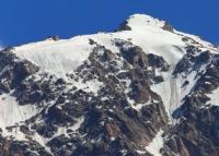
Glaciers in headwaters of Chilik’s tributaries.
"The Chilik glaciers are the largest in the area. The biggest among them - named after the renowned geographer Korzhenevsky - stretches for nearly 12 kilometers. Next in size is the Bogatyr Glacier. It is located nearby within the same river basin; while 8 kilometers long, it is notable for the vast surface area of its upper reaches. Both glaciers, which bear a strong resemblance to one another, form a picturesque natural landscape where massive snowbanks, hanging as cornices along the mountain slopes, lend the scene an appearance that is at once rugged and spectacular."
Nikolai Nikitich Palgov. «Nature of Kazakhstan in Sketches and Pictures”. 1950.
A tour of Chilik River valley.
The upper course of the Chilik River occupies a longitudinal valley situated between the Zailiysky Alatau and Kungey Alatau ranges. Glaciation within the basin occurs across both ranges. The total glaciated area - estimated by N. N. Palgov at 300 sq. km. - is distributed almost equally between the two ranges.
A portion ,of this area consists of the Zhangyryk (Dzhangyryk) Glacier, which is shared by both ranges. If one-third of this glacier is attributed to the Zailiysky Alatau, the total glaciated area on the northern side of the Chilik basin (belonging to the Zailiysky Alatau) amounts to 141 sq. km.
More than 41 glaciers are found in this territory. The primary glaciation is concentrated on the eastern slopes of the main ridge. The most massive glaciers - Korzhenevsky, Bogatyr, and Zhangyryk - are concentrated here. The combined area of just the first two, including their tributaries and firn fields, accounts for approximately 75% of the total glaciation in the northern part of the Chilik River basin.
Like other glaciers in Zailiysky Alatau, these two giants (by local standards) are remnants of much larger glaciers from the past. It is possible that they were once joined during historical times, and that the Zhangyryk Glacier also reached them during an even earlier period.
An old frontal moraine - which blocks the Chilik Valley downstream from the point where the Southeastern Talgar enters it - dates back to the phase when all three glaciers existed as a single, united system.
Geographic coordinates of Chilik River: N43°02'44 E78°16'10
Zhangyryk Glacier in Chilik River basin.
This glacier occupies a headwater basin that is divided by mountain spurs into two large reservoirs. The Zhangyryk Glacier is classified as a cirque glacier. It originates from the southeastern slopes of the Zailiysky Alatau, the eastern slopes of the Chilik-Kemin saddle, and the northeastern slopes of the Kungey Alatau range.
Constitution Peak rises on the left side of the cirque's headwall, while a 4,775-meter peak stands on the right (situated on the Kungey Alatau ridge). The glacier consists of two branches: a left (western) branch and a right (southern) branch. The left branch, which is the main one, flows eastward. It originates from a six-chambered cirque, behind the rear walls of which lie the headwaters of the Chon-Kemin River.
The right branch begins in a three-chambered cirque, the rear wall of which bears the highest peaks. The upper course of this branch flows northward, while the lower course flows east-northeast. According to observations by S. E. Dmitriev in 1909-1910, the glacier's firn line lay at an altitude of 3,700 meters.
The Zhangyryk Glacier is remarkably picturesque. Dazzling white snows slide down into its cirque from gently sloping, rounded hills. Bare rock outcrops appear only occasionally on the snow-covered mountain slopes. Broad firn fields stretch smoothly toward the ridge crest.
Three flows descend from the side slopes to the glacier's left branch: two from the left and one from the right. Two tributaries join the right branch from the left side. The glacier tongue descends into the valley via three steep terraces. In these sections, the ice is broken into separate blocks covered by moraine deposits.
In places, ice cliffs peek out from beneath this continuous rocky armor. In addition to the main glacier and the five tributaries feeding its two branches, there are six other small glaciers in the headwaters of the Zhangyryk River. One of them, Syrgymymalymuz, lies in a high cirque carved into the valley's left slope, above the terminus of the main glacier; another, Zhusandy-Kungei - also a cirque glacier - is situated to the east within the Zhusandy-Kungei massif; further east, there are two more, smaller glaciers.
The other two glaciers lie on the right side of the valley: one higher up (a hanging glacier) and the other lower down, in a deep lateral extension of the valley. The total area of all glaciation in the Zhangyryk basin (including glaciers on the slopes of the Kungei Alatau Range) exceeds 30 sq. km (“Glaciation of the Zailiysky Alatau”, 1969).
Geographic coordinates of Zhangyryk Glacier: N42°57'25 E77°10'39
Bogatyr Glacier in Chilik River basin.
This is the second-largest glacier in the Zailiysky Alatau. According to its discoverer, S. E. Dmitriev, the Bogatyr Glacier is of the basin type. It lies at the headwaters of the Southeast Talgar River. Its rear boundary is formed by the eastern slope of the main ridge; the glaciers on the opposite (western) side of this ridge - Toguzak, Kalesnik, Pioner, and Severtsov - derive their nourishment from the same massif.
The highest peak is Bogatyr Peak (4,626 m). To the south, the Bogatyr Glacier is bounded by the Zhusandy-Kungei lateral spur, and to the north by the Southern Issyk spur, which bears the 4,800-meter-high Issyk-tenshoku Peak. The upper reaches of the glacier are divided by lateral mountain spurs into three basins.
S. E. Dmitriev gave these basins distinctive names: the left basin is *Shuitsa* (Left Hand), the middle is *Golova* (Head), and the right is *Desnitsa* (Right Hand). *Shuitsa* features a multi-chambered cirque, while *Golova* and *Desnitsa* have single-chambered cirques. The *Golova* cirque is enclosed by a ridge.
A section of this ridge forms the Toguzak Saddle. Upon emerging from their separate basins, the three branches of the glacier merge into one, marking the confluence points with medial moraines. Excluding the frontal moraines, the glacier is approximately 8 km long; it is 2,300 m wide at the confluence of its three branches and 700 m wide near the terminus of the tongue.
The upper reaches of the Bogatyr Glacier are characterized by sharp, austere contours. Here, sheer rocky peaks rise amidst the smooth and undulating surfaces of the cirque. Their southeastern faces are completely bare. The northwestern faces, by contrast, are covered in thick, hummocky snow masses.
Some of the gentler peaks are entirely submerged in these snowdrifts, while the steeper ones are streaked with bands of snow lying in gullies and recesses. In its lower reaches - where the gradient is approximately 60 degrees - the glacier is gradually covered by moraine deposits.
Scattered haphazardly across the moraine are cliffs, depressions, and occasional hollows containing small pools of water. On the left side, the glacier terminates in a steep, inaccessible face, whereas on the right, it is completely buried beneath rock debris.
At one point, the moraine deposits are strewn with massive boulders that likely broke off from the adjacent mountain slope during an earthquake. Deep ravines separate the glacier's right and left flanks from the mountain slopes. Glacial streams issuing from various parts of the glacier fan out across the outwash plain (sandur), which forms a lake-like widening of the valley.
In addition to the main glacier, the Southeast Talgar basin contains eight other glaciers. Four of these glaciers are situated in cirques on the southern slope of the Issyk Spur. The uppermost of these (in terms of flow direction) is approximately 1.0-1.5 km long, and its terminal moraine abuts the lateral moraine of the Bogatyr Glacier.
The remaining three glaciers are small; they are located further downstream, one after another. Four glaciers are situated on the northern slope of the Zhusandy-Kungei Spur. All of them have a northeasterly aspect. Three are cirque glaciers, and one is a hanging glacier.
The total area of glaciation in the Southeastern Talgar basin is approximately 45 sq. km.
Geographic coordinates of Bogatyr Glacier: N43°01'14, E77°14'53.
Korzhenevsky Glacier in Chilik River basin.
This glacier is the largest in the Trans-Ili Alatau. It covers an extensive area at the headwaters of the South Issyk River, situated between the South Issyk Spur and the main ridge, which curves around the glacier’s rear and left side. The Korzhenevsky Glacier is a valley glacier fed by snows from the highest section of the main ridge; Talgar Peak is located almost at the center of the ridge section behind the glacier.
The average elevation of the mountain section supporting the glacier's firn fields is approximately 4,500 m. The exposed terminus of the glacier tongue descends to an elevation of 3,300 m. The vertical distance between the glacier's highest and lowest points reaches 1,717 m.
The glacier is approximately 11.2 km long and covers an area of about 38 sq. km. The head of the glacier lies within four firn basins, with the outermost ones being the largest. The view of these basins, framed by the towering surrounding mountains, is the most majestic in the entire Zailiskiy Alatau.
The back walls of the cirques form a continuous snowfield, inclined at an angle of 25-30° and broken in places by the weight of heavily settled snow masses (“Glaciation of the Tien-Shan”, 1995). Each firn basin contributes a branch to the glacier.
Two central branches originate from four basins near Talgar Peak; they are short, measuring 300-350 m in width, and merge into a single stream shortly after exiting the cirques. The left branch, extending up to 8 km in length and over 1 km in width, descends from the Kopyr and Metallurg peaks.
Initially flowing southeast, it gradually curves; with a southern aspect, it approaches the central branch - from which it is separated in its upper reaches by a spur extending from the Vostochny (Eastern) Talgar peak. A left medial moraine extends along the glacier from the end of this spur.
The right branch, up to 5 km long and 4 km wide, originates on the east-facing slope of the main ridge, where two entirely snow-covered peaks exceeding 4,600 m in elevation stand out: Vseobuch Peak (4,650 m) in the southwest corner - from which the Issyktekshoku spur begins - and Bely (White) Peak in the center.
Initially, the branch flows eastward but turns south upon encountering a lateral spur. The glacier's width reaches 4 km at the confluence of all the branches, gradually narrowing thereafter. In the lower reaches of the glacier tongue, the width reaches 700-800 m.
The glacier surface has a longitudinal slope exceeding 7°. In places - particularly near the firn line - it is dissected by crevasses; these form a labyrinth in the upper section of the right branch, while creating icefalls on the left branch. Glacial mills and shafts occur in some areas (Gorbunov, 1939).
In its upper reaches, the glacier carries four medial moraines; two of these subsequently merge into one. The main meltwater stream rushes turbulently along the glacier tongue within a deep canyon. At its terminus, which has a southern aspect, the glacier tongue steepens and breaks up across its entire width into a series of steps.
The remainder of the glaciated area in the Yuzhny Issyk basin consists of 12 small glaciers with a total area of approximately 10 sq. km. Eight of these glaciers are situated on the eastern slope of the Yuzhny Issyk Spur. All are cirque glaciers facing east and northeast, toward the right side of the Korzhenevsky Glacier.
Two larger glaciers (up to 1.5 km in length) emerge from cirques and enter narrow "hanging gorges," forming hanging tongues with very steep gradients. Four glaciers are situated on the western slope of the main ridge and a spur located south of the Kokbulak peak.
They have a south-westerly aspect and face the left side of the Korzhenevsky Glacier. All of these are cirque glaciers, reaching lengths of up to 1.5 km. Their termini, framed by moraine deposits, lie within short gorges on the slope and do not reach the main glacier.
Geographic coordinates of Korzhenevsky Glacier: N43°05'33 E77°22'03
References:
Gvozdetsky N. A., Nikolaev V. A. "Kazakhstan". Moscow: Mysl, 1971.
Gvozdetsky N. A., Mikhailov N. I. "Physical Geography of the USSR". Moscow: Mysl, 1978.
Zhivago N. V., Piotrovsky V. V. Geomorphology with Fundamentals of Geology. Moscow: Nedra, 1971.
Catalogue of Glaciers of the USSR. Leningrad, 1967, Vol. 13, Issue 2, Part 1.
Catalogue of Glaciers of the USSR. Leningrad, 1967, Vol. 13, Issue 2, Part 2.
Tuyuksu Glaciers (Northern Tien Shan). Leningrad: Gidrometeoizdat, 1984.
Glaciation of the Tien Shan. Ed. N. B. Dyurgerov. Moscow, 1995.
"Glaciation of the Zailiysky Alatau." Moscow: Nauka, 1969.
Palgov N. N. The Bolshaya Almatinka Glaciation Cluster in the Zailiysky Alatau Range. *Izvestiya Vsesoyuznogo geograficheskogo obshchestva* [Proceedings of the All-Union Geographical Society], 1948, Vol. 80, Issue 1.
Palgov N. N. Shokalsky Glacier in the Zailiysky Alatau Range. "Izvestiya Vsesoyuznogo geograficheskogo obshchestva* [Proceedings of the All-Union Geographical Society], 1948, Vol. 80, Issue 1.
Palgov N. N. Trip to the Tuyuksu Glacier in the Summer of 1922 (Offprint from *Izvestiya GRGO*, Vol. LVIII), 1926.
Tokmagambetov G. A. Glaciers of the Zailiysky Alatau. Alma-Ata, 1976.
Tokmagambetov G. A. Secrets of Kazakhstan's Natural Ice. Alma-Ata: Nauka, 1978.
Svarichevskaya Z. A. "Geomorphology of Kazakhstan and Central Asia". 1965.
Chedaya O. K. "Morphostructures and Recent Tectogenesis of the Tien-Shan". Frunze: Ilim, 1986.
Material prepared using data from:
Glaciological studies and works by scientists: S. E. Dmitrieva, N. N. Palgova, G. A. Tokmagambetova (*Glaciers of the Zailiysky Alatau*, 1976), K. G. Makarevich, and E. N. Vilesov.
Article: "Glacial Structures of the Northern Tien Shan – Zailiysky Alatau."
http://www.bigmir.net
https://elib.rgo.ru/safe-view/123456789/226999/1/0LPQtdC+0LsuMjRfVGFsZ2FyLCBnbGF2bmF5YSB2ZXJzaGluYSBaYWlsaWlza29nbyBBbGF0YXUsIGJsaXoucGRm
Photos by:
Alexander Petrov.