


![]()
You are here
Caravan routes of Kazakhstan.


.")


Tours on Silk way of Southern Kazakhstan.
"Оn entering the limits of the Tien Shan the wanderer from the Apennines made а stop to have а short rest in Kassae (Hanchjow).
There he marvelled not only at the emperor's garden and palaces оn the man-made hilI of Guashan and the Sihu Lake with hundred-year-old turtles and the Un'he - the Great саnаl of 3,564 leas long (1 lеа = 500 metres)"
"...In search of profit, the whole world is their path.
In their wanderings, they trust in God...
Their paths stretch from one end to the other,
So that you may find the desired message,
And thousands upon thousands of treasures of the universe,
You will find, O wise one, in their priceless burden..."
Yusuf Balasuguni.
Tour Historic Monuments of Kazakhstan.
The Great Silk Road is one of the most significant achievements in the history of world civilization.
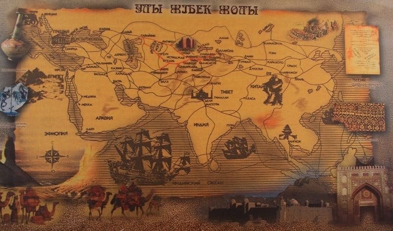
Extensive networks of caravan routes crossed Europe and Asia from the Mediterranean to China, serving in ancient and medieval times as an important means of trade and dialogue between the cultures of the West and the East.
The longest section of the Silk Road passed through Central Asia and Kazakhstan.
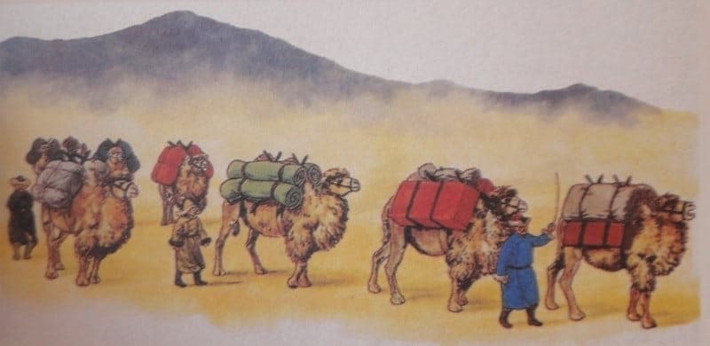
Caravans laden with silk from China, spices and gems from India, silverware from Iran, Byzantine linens, Turkic slaves, Afrosiab ceramics, and many other goods traveled through the deserts of Karakum and Kyzylkum, through the oases of Merv and , and across the boundless steppes.
They crossed the Sary-Arka Pass; they overcame the passes of the Pamirs and Tien-Shan, Altai and Karatau; and crossed the Murghab and Amu Darya, Syr Darya, and Dzhaik rivers. The caravans passed through wealthy villages and cities along the route - Merv and Bukhara, Samarkand and Urgench, Otrar and Chimkent, Taraz and Balasagun, Sauran and Talgar.
The question of when this route first began to function remains a matter of debate. If we consider the prototypes of individual sections of the Silk Road, the beginning of contacts and exchanges dates back to the IVth-Vth millennia BC. These connections were established in connection with the development of lapis lazuli deposits in the Jurassic of Bodakhshan and jade deposits in the upper reaches of the Yarkand Darya River, near Khotan.
Lazurite mined in Badakhshan was exported to Iran, Mesopotamia, Anatolia, Egypt, and Syria. In the mid-Ist millennium BC, Bodakhshan lapis lazuli appeared in China. Along with the Lazurite Road, which connected Central Asia and the Middle East with the Mediterranean and India, there was the Jade Road, which linked East Turkestan with China.
In the mid-Ist millennium BC, the Steppe Road began to function. If we follow the description of this route by Herodotus, the father of history, its direction becomes clear: from the Black Sea region to the banks of the Don, then to the lands of the Sauromatians in the Southern Urals to the Irtysh, and further to the Altai, to the land of the Argippians, who inhabited the Upper Irtysh and Lake Zaysan region.
Until recently, it was believed that the invention of silk and its trade dated back to the first millennium BC. However, Chinese archaeologists excavating in Zhejiang Province, near Lake Taihu, found silk fabrics, belts, and yarn dating back to the Neolithic era.
The fabric dates back to approximately 2750 BC. Analysis of the fabric showed that sericulture had developed considerably and emerged from its primitive stage almost five thousand years ago. In the sixth and fifth centuries BC, Chinese silk began to be exported to other countries, including the West.
A silk blanket embroidered with phoenixes was found during excavations at one of the "royal" burial mounds of Pazyryk in the Altai Mountains, dating back to the Vth century BC. Silk fabrics and fringe sewn onto woolen items have been found in burials dating back to the VIth-Vth centuries BC in southern and Western Europe.
The nomadic Saka and Scythian tribes contributed to the spread of precious Chinese silks, facilitating the introduction of this exotic commodity to Central Asia and the Mediterranean. Silk also reached India at this time. This is evidenced by the word "sinapatto" (Chinese silk), found in the treatise "Arthashastra" ("Science of Politics"), written in the IVth century BC.
However, most researchers believe that at this time, the Silk Road was only just beginning to emerge and take shape as a trade route. It was only in the mid-XIth century BC that the Silk Road began to function as a regular diplomatic and trade artery.
It all began in 138, when an embassy caravan departed from the Han capital, accompanying Prince Zhang Jian, sent by Emperor Wu of China set out to unknown Western lands. After 13 years, Zhang Jiang returned. He reached the region of today's Afghanistan and was the first to establish a direct route from the interior of China to Central Asia.
Following him, silk caravans followed this route to the West, and goods from the Mediterranean, the Near and Middle East, and Central Asia returned to China. Soon, international trade passed into the hands of merchants from Sogdiana, a country located in Central Asia in the valleys of the Zeravshan and Kashka Darya rivers.
The Sogdians had trading colonies in the "Tokar" cities of East Turkestan and in Chinese cities such as Lanzhou, Dunhuang, and Chang'an. For example, about a thousand Sogdians lived in Dunhuang. The Sogdians penetrated Japan, where the Silk Road ended at the ancient Japanese capital of Nara. Here, in one of the temples, a manuscript written in the Sogdian language is kept.
In the VIth-Vth centuries, the Silk Road, coming from the East, began in Chang'an and ran to the Yellow River crossing near Lanzhou, then along the northern spurs of Nanshan to the western edge of the Great Wall of China and the Jade Gate Outpost.
Here, the single road branched, bordering the Taklamakan Desert to the north and south.
Northern part of Great Silk Road.
The northern route ran through the oases of Hami, Turpan, Beshbalik, and Shikho to the Ili River valley. The middle route ran from Chaochang to Karashahr, Aksu, and through the Bedel Pass to the southern shore of Issyk-Kul.
Southern part of Great Silk Road.
The southern route, through Dunhuang, Khotan, and Yarkand to Bactria, India, and the Mediterranean, is the so-called Southern Route. The northern route ran from Kashgar to Fergana and then through Samarkand, Bukhara, and Merv to Kamaden and Syria.
The emergence of trade routes is associated with the process of urbanization, which first affected the southern regions of Central Asia, then the central regions, and only in the third stage did it reach the adjacent northern and steppe regions. Therefore, it is appropriate to distinguish three types of land routes running through Central Asia: southern, central, and northern.
The southern route began at Amul on the Oxus and branched in three directions: through Bukhara, Kasan, Kerki, Termez, and Baktra; through Bukhara, Samarkand, Shakhrisabz, Kerki, the Acrobat Pass, Termez, and Baktra; Through Bukhara, Samarkand, Uzunkir, Daratepe, Budrach, Khaitabattepe, Termez, and Baktra.
Central part of Great Silk Road.
The central route passed through Amul on the Oxus, to Paykend, Bukhara, Samarkand, Dizak, Zaamin, Samgar, Khajistan, Turmukan, Bab, Akhsiket, Osh, Uzgend, and further through the passes to Kashgar. The northern route ran through Amul to Bukhara, Dimas, Tawavis, Karmana, Dabusiya, Rabinjan, Zaman, Samarkand, Abarket, Rabad, Sayeda, Kharkana, and Dizak.
In this region, the route split into two branches: from Zaman to Hawas, Kharashkat, crossing the Yaksart, to Benaket, Binket; From Dizak through the wells of Hussein and Humeyd to Vankerd, Unjaket, Chinanchiket, and further to Shuturket, where this route merged with the southern branch and led to the capital of Shash, Binket.
In the VIth and Viith centuries, the route that ran from China to the west through Semirechye and southern Kazakhstan became the busiest, although the previous route through Fergana was shorter and more convenient. The shift in route can be explained by the following factors:
Silk Road in Semirechye.
First, Semirechye was the headquarters of the Turkic khagans, who controlled trade routes through Central Asia. Second, the route through Fergana became dangerous in the VIIIth century due to civil strife. Third, the wealthy Turkic khagans and their entourage became major consumers of overseas goods.
Thus, this route became the main one, and the main embassy and trade caravans passed through here from the VIIth to the XIVth centuries. It should be noted that the Silk Road route was not static; it changed over the centuries. Depending on various factors, certain sections and branches gained greater importance, while others, on the contrary, died out, and the cities and trading stations along them fell into decline.
In the VIth to VIIIth centuries, the main route was Syria - Iran - Central Asia - Southern Kazakhstan - Talas Valley - Chui Valley - Issyk-Kul Basin - East Turkestan. A branch of this route, or rather another route, connected with the aforementioned route from Byzantium through Derbent to the Caspian steppes - Mangyshlak - Aral Sea region - Southern Kazakhstan.
It bypassed Sassanid Iran, when a trade and diplomatic agreement was concluded in opposition to it. The alliance of the Western Turkic Khaganate and Byzantium. However, later, in the IXth-XIIth centuries, this route was used less intensively than the one that ran through Central Asia, the Middle and Near East, and Asia Minor to Syria, Egypt, and Byzantium.
However, in the XIIIth-XIVth centuries, this route was revived.
Often, the political situation on the continent dictated the choice of routes not only for diplomats and merchants, but also for other travelers. What was southern Kazakhstan and Semirechye like during the period when they were part of the Silk Road?
A distinctive culture, shaped by nomadic tribes and sedentary peoples, has developed in this region since ancient times. It should be noted that, ethnically, the nomads and sedentary peoples were either homogeneous or united within similar ethnopolitical entities.
The interaction and mutual enrichment of cultures - sedentary and nomadic - provided the world with a remarkable result, which underlies many of the achievements of the civilizations created by the peoples of Kazakhstan and Central Asia, as well as the origins of the ethnogenesis of the peoples inhabiting it.
From the VIth to VIIst centuries BC, the nomadic and semi-nomadic Saka tribes inhabited this region, whose high culture is known from the excavations of numerous burial mounds, including Besshatyr, Issyk, Tegisken, and Uygarak. During the reign of the Wusun and Kangju in the IInd century BC to the first half of the Ist millennium AD, when the Silk Road began to function actively, Roman glass and lunettes, Chinese silk, mirrors and lacquerware, European brooches and clasps, and carved seal stones from Sassanid Iran arrived here. In the second half of the sixth century, Semirechye and southern Kazakhstan became part of the Turkic Khaganate, a vast nomadic empire spanning from Korea to the Black Sea.
At the end of the sixth century, the Khaganate split into two parts - the Eastern Turkic and the Western Turkic. Semirechye became the center of the Western Turkic Empire, with the city of Suyab as its capital. It was during this time that trade along the Silk Road revived, playing a significant role in the development of the urban feudal culture of Semirechye and southern Kazakhstan.
A number of new urban centers emerged in Semirechye, while in southern Kazakhstan, cities that were either located along the Silk Road itself or were connected to it through trade relations experienced rapid growth. This is confirmed by historical records.
While sources from the first half of the first millennium AD mention only two cities - Chigū in Semirechye, the residence of the Wusun rulers, and Bityano in southern Kazakhstan, the capital of the Kangju - by the early seventh century, sources report several dozen new cities.
The largest of these were Suyab, Taraz, and Ispidzhab. The Silk Road, which passed through Central Asia, southern Kazakhstan, and Semirechye, was active until the fourteenth century, when internecine wars and strife led to the destruction of urban culture, and the intensive exploration of sea routes in Southeast Asia and China sharply reduced the number of overland caravans.
What did the Kazakhstan section of the Silk Road look like if you traveled from west to east? From Shash (Tashkent), the road went through a pass to Tarbat and to Ispidzhab. Ispidzhab was referred to in Chinese road maps as a city on the White River, and in the th century, Mahmud of Kashgar explained that "Sairam is the name of the White City (Al-medinat al-Bayda), which is called Ispidzhab."
It is also called Saryam. The name of the ancient city has survived to this day. Sairam is the name of a village near Chimkent, in the center of which are the remains of a medieval settlement, the site of which was once one of the largest centers on the Silk Road.
Merchants from various countries stopped here. The center housed trading buildings and caravanserais belonging to envoys from Bukhara and Samarkand. Merchants from Ispidzhab had their trading posts in Baghdad in the rabad of Harb ibn Abdallah al-Balkhi, along with merchants from Merv, Balkh, Bukhara, and Khorezm.
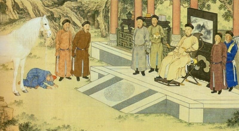
From Ispidzhab, caravans traveled east to Taraz via the cities Sharab, Budukhket, Tamtaj, and Abardaj. Taraz is one of the oldest cities in Kazakhstan, known as early as the 6th century. It was here that the Turkic Khagan Dizabul received the diplomatic embassy of Justinian II of Byzantium in 568, led by the strategist Zemarchus, who had arrived to conclude a military alliance against Iran and resolve issues related to the silk trade.
Historical chronicles refer to Taraz as a city of merchants. It was also the capital of the Turgesh, and later the Karluks and Karakhanids. Near Taraz, the city of Jamukat once stood, founded by the Sogdians of Bukhara under the leadership of Jamuk, after whom the city was named.
This city is also mentioned in chronicles of the VIth century. Time has erased traces of this city, but archaeologists have been able to locate Jamukat and excavate its ruins. The city was located in the Talas region. A valley near Dzhambul on the right bank of the Talas River.
The ruins of this city are now called Kostobe, meaning "Double Hill." Besides these cities, the Talas Valley also included such famous towns as Sheldzhi, Sus, Kul, and Tekabket, located in the mountainous part of the valley, where large silver mines were located.
Caravans also reached the Talas Valley and Taraz via the road from the Fergana Valley, leading from Kasan through the Chanach Pass in the Chatkal Range and Karabura. From Taraz, caravans traveled east through the desert to the city of Kulan.
The route to Kulan required passing through Kasribas, Kul-Shub, and Dzhul-Shub. The city of Kulan, which the Chinese called Julan, was known as "a pleasant town on the borders of the Turkic lands from Maveranahr." According to route maps, it was located 17 farsakhs east of Taraz and corresponds to the ancient settlement of Lugovoe, located on the eastern outskirts of the modern town of the same name.
From Kulan, further east, 4 farsakhs apart, stood the settlements of Mirki and Aspar. From Dzhul, the road led to Saryg, then to the village of the Turkic Khagan and to Kirmirau. From Kirmirau, the road led to one of the largest cities of Semirechye, Navaket, or Xingcheng in China.
Both of these names translate as Novgorod. Navaket is known as the residence of the Turkic Khagans and as a city of the Sogdians. The Krasnaya Rechka settlement corresponds to Navaket. From Navaket through Penjikent (Bunjiket), the road led to Suyab, the largest city in Semirechye.
It was the capital of the Western Turks, then the Turgesh, and the Karluks. Chinese and Arab travelers wrote about it until the 10th century, when it suddenly disappears from the pages of chronicles. The role of capital passed to the city of Balasagun.
This city is known as the capital of the Karakhanids, then the Kara-Khitans, who destroyed it in the early XIIIst century. The city was then rebuilt, but by the XIVth century it lay in ruins again, and only dilapidated palaces, mosques, minarets, and extensive cemeteries with epitaphs testified to the formerly vibrant life here.
Archaeologists have been able to determine the location of these cities: they are located near the modern city of Tokmak and correspond to two well-known medieval sites – the Akbeshim settlement and the Burana settlement. From Suyab, the Silk Road passed either along the northern or the southern route or along the southern shore of Lake Issyk-Kul.
On the southern stretch, caravans passed the large city of Upper Barsakhan, while the northern stretch is marked by the remains of small caravanserais, the names of which have not survived. These routes then converged at the Bedel Pass, and through it or through Tashrabat, the Silk Road led to Kashgar and Aksu. From the Issyk-Kul Basin, the route led through the Santash Pass to the Ili Valley, then along the right bank or through the valleys of Usek and Khorgos, leading to Almalyk, and then along the northern edge of the Taklamakan Desert, through the oases of Hami and Turpan, to Dunhuang and China.
In the Xth-XIIth centuries, one branch of the Silk Road crossed the entire Ili Valley from southwest to northeast. This route began in Navaket, then went to Bunjiket, and through the Kastek Pass, reached the northern slopes of the Ili Valley. the Zailiskiy Alatau.
A prominent landmark here was the sacred Urun-Arj Mountains, which form the watershed between the Chu and Ili River basins. Chinese road builders mentioned these mountains as early as the 7th-8th centuries, calling them the Jiedan Mountains.
According to sources, the Khagan of the Ten Clans always confirmed rulers and elders here. The toponym Urun-Arj still survives in the name of the modern village of Uzun-Agach. The Silk Road route passed through small towns located on the sites of Kastek, Kaskelen, and Alma-Ata, and reached the city of Talkhiz, located on the northern outskirts of Talgar.
Here, at the foot of the mountains on the right bank of the Talgar River, are the ruins of a large medieval settlement. Talkhiz (Talkhir) was a major transit trade center. In Talkhiz, the Silk Road branched off. The southern route ran through Issyk, Turgen, and Chilik to the crossing of the Ili River in the region.
Borokhudzir, and then along the right bank of the Ili River through Khorgos to Almalyk, connecting with the route that came here from the Issyk-Kul Valley. Along this stretch, archaeologists have found the ruins of the small towns of Issyk, Turgen, and Lavar, as well as the large city of Chilik.
The northern road from Talkhiz ran along the Talgar River to the Ili crossing, which was located in the Kapchagay Gorge. After the crossing, the road led to Chingildy, and then, through the Altyn-Emel Pass, descended into the Koksu Valley and led to the city of Iki-Oguz, located near the modern village of Kirovskoye.
It was here that one of the largest settlements in the Ili Valley was discovered. According to the wandering monk William of Rubruck, who visited these areas in 1253, this city was inhabited by Saracens—as Iranian merchants were called at that time. Rubruck called the city Equius.
From Iki-Oguz The route led to Koyalyk (Koylak), the capital of the Karluk Djabgu. The city was famous for its bazaars, and in addition to Muslims, Christians lived there, who had their own Church. This is reported by William of Rubruck, who visited the city.
Not far from Kayalyk, according to Rubruck's notes, there was a Christian village through which the Silk Road also passed. The route then continued into the Tentek Valley and, after skirting the Ala Kul, through the Dzungor Gate into the Shikho Valley and from there, through Beshbalik, to Dunhuang and inner China.
Let us return, however, to one of the starting points on the Kazakhstan section of the Silk Road - the city of Ispidzhab - to follow the route of the Byzantine strategist Zemarchus - from Taraz through Ispidzhab to the Aral Sea region and further to Europe.
From Ispidzhab, a caravan route led to Arsubaniket, then to Otrar-Farab and further down the Syr Darya. The largest cities on the caravan route, which ran along the Syr Darya, were Otrar-Farab and Shavgar. The name of the first city has survived to this day as the name of a large settlement located near the confluence of the Arys and Syr Darya.
Otrar was a hub of caravan routes. From here, one road led to Shavgar, and another to the Syr Darya crossing and the city of Vesidzh, the birthplace of the eminent Eastern scholar Abu Nasr al-Farabi. From this city, the road ascended the Syr Darya, through the Oghuz city of Syutkent to Shash, and then down to Jend.
From here, a route was laid through the Kyzylkum Desert to Khorezm, Urgench, and from there to the Volga region and the Caucasus. This section of the Silk Road was particularly busy in the XIII1st century, when Sarai, the capital of the Golden Horde, was located on the lower reaches of the Volga.
Shavgar was mentioned in sources in the VIIst century; it apparently corresponds to the settlement of Kultobe in Turkestan. In the Xth-XIIth centuries, the city of Iasi emerged on the site of Shovgar, where the renowned Sufi poet Ahmed Yasawi lived and preached. A majestic mausoleum was built over his grave in the XIVth century by order of Timur.
From Shovgar, the route led to the city of Yangikent, the capital of the Oghuz state, through the Keilkum Mountains to Khorezm. From Shavgar, and later Iasi, through the Turlin Pass, the Silk Road reached the northern slopes of Karatau and paralleled the route along the Syr Darya.
This route was particularly active in the XIIIth-XIVth centuries. It was along this route that the Armenian king Getum and the monk Rubruk traveled from the northern Aral Sea region to Mongolia. The cities of Suzak, Urosotan, Kumkent, and Sugulkent stood along this route.
This route led to Taraz. From the main Silk Road route in Ispidzhab, Otrar, and Yangikent, routes branched off to the north and east, leading to the Dasht and Kipchak steppes of central and eastern Kazakhstan, later called Saryarka, to the banks of the Irtysh, to the Altai, and to Mongolia.
The steppe regions of Kazakhstan were inhabited not only by nomads. In areas favorable for agriculture - in the valleys of the Sarysu, Kengir, and Dzhezdy rivers, in the foothills of Ulutau, and on the banks of the Irtysh—oases of agricultural and urban life emerged and developed during the Middle Ages.
Rich deposits of copper, tin, lead, and silver had been mined since the Bronze Age, and in later times, settlements of miners, metal smelters, coppersmiths, and silversmiths arose here. The regions of Central Kazakhstan were exceptionally rich in natural resources, with lush flocks of sheep and herds of horses grazing here, which is why these areas were included in the Silk Road system.
From Taraz, through the cities of Adakhkes and Deh-Nudzhikes, the trade route extended to the Irtysh River, to the residence of the Kimak khakan, and further on to the land of the Kyrgyz on the Yenisei. The Ili Valley was connected to Central Kazakhstan by a road running along the northern slopes of the Chuili Mountains, along the Chu River to its lower reaches, and then to the banks of the Sarysu.
Another important route branched off from the Northern Ili route in the Chingildy region. It ran along the Ili Ortasu branch of the River and reached the shores of Lake Balkhash, then passed along the Uzungaral Peninsula, which almost connects the southern and northern shores of the lake, leaving a strait just over 8 kilometers wide.
It can be assumed that caravans waded across this strait and emerged at the mouth of the Tokrau River, ascending along its banks to the Ulutau foothills. From the Northern Ili route, which led to the Dzungor Gates, a route branched off, skirting Ala Kul on the western side and leading through Torbagatai to the Irtysh River, into the lands of the Kimak state.
Kumak cities - Banjar, Khanaush, Astur, and Sisan - were located in Torbagatai and on the banks of the Irtysh. These cities were connected by trade routes with the Kyrgyz cities on the Yenisei, the Uyghurs in Mongolia, and the oases of Eastern Turkestan.
These are the routes of the Silk Road in southern Kazakhstan and Semirechye. The Silk Road initially served to export Chinese silk to Western countries. In turn, goods produced in these countries traveled along this route from Rome, Byzantium, India, Iran, the Arab Caliphate, and later Europe and Rus'.
The list of these exotic and exotic goods is endless. These included myrrh and frankincense, jasmine water and amber, cardamom and nutmeg, ginseng, python bile, carpets and fabrics, dyes and minerals, diamonds and jasper, amber and coral, ivory, silver and gold ingots.
Furs and coins, bows and arrows, swords and spears, and much more. The Silk Road was used for trade, carrying thoroughbred horses from Fergana, Arabian and Nisian horses, camels and elephants, rhinoceroses and lions, cheetahs and gazelles, hawks and falcons, peacocks, parrots, and ostriches.
Cultivated crops spread along the Silk Road: grapes, peaches and melons, spices and sugar, vegetables and fruits, and herbs. However, silk remained the main commodity of trade. Silk, along with gold, became an international currency, used as gifts to kings and ambassadors, to pay mercenary troops, and to settle government debts.
It is no coincidence that silk garments are meticulously depicted with numerous embellishments and details in the frescoes of the palaces of the rulers of China, Central Asia, and East Turkestan. It's only natural that both silk and some of the goods transported along the Silk Road ended up in cities located along the Central Asian-Kazakhstan route.
Archaeological finds are clear evidence of this. The Silk Road spread not only products but also fashions for artistic styles, which could have a social impact and, finding favour in a particular ethnocultural environment, became widespread. It is believed that the Timurid style of ceramics, distinguished by its blue paint scheme on a white background, spread along the Silk Road.
Originating in the imperial workshops of China during the Yuan Dynasty (1279-1368), this style was particularly developed in Iran, Turkey, and Central Asia. Excellent examples of ceramic bowls and vases painted with cobalt adorn the exhibitions of many museums around the world.
At the beginning of the Middle Ages, a unique theory of the formation of the largest world kingdoms - China, India, Persia, and Byzantium - was widespread in Asia. These kingdoms symbolized specific types of culture and state power. The creation of these monarchies, located in the four cardinal directions, was closely linked to the abundant natural resources of these countries.
India was considered the kingdom of elephants (south), Iran and Byzantium the kingdom of jewels (west), the Turkic Khaganates (north) were part of the kingdom of horses, and China (east) was recognized as the kingdom of men. In this regard, the murals in the village of Kushania, near Samarkand, covering the walls of a building, are of interest.
One depicts Chinese emperors, another Turkish khans and Indian Brahmins, and a third Persian kings and Roman emperors. These murals seem to depict examples of global state power. World culture, too, did not arise out of nowhere. It absorbed the achievements of many national cultures and was the fruit of the collective creativity of various ethnic groups.
The contributions of various peoples to the world's treasury are reflected in the verses of the poet Nosir Khisrow:
"Know that in poetry there are no better horsemen than the Arabs, and the sons of ancient Greece chose medicine as their arena.
In sorcery, the Hindus are strong, mathematics and music are the domain of the Romans."
China's power in design is firm. But the world has never seen more skilled artists than the Baghdad masters. The famous Persian Sufi poet Jalal al-Din Rumi, who lived from 1207 to 1273, wrote about the interaction, penetration, and enrichment of cultures, mutual tolerance, and respect for one another.
He preached compassion for the oppressed and poor and denounced tyranny, greed, and hypocrisy:
"How often does it happen that a Turk and an Indian find common ground? How often does it happen that two Turks are like strangers. Therefore, the language of unanimity is a completely different matter: unanimity is more precious than monolingualism."
It is no coincidence that Muslims, Christians, Jews, and Buddhists also accompanied the final journey of the "singer of the religion of the heart," who died in the city of Konya. Along with the spread of goods and cultural examples in applied arts, architecture, and murals, the art of music and dance, a kind of "variety art" of the Middle Ages, spread across the countries of the East and West.
Spectacular performances, including those of musicians and dancers, wild animal tamers, acrobats and mimes, magicians, and illusionists, were particularly mobile and required no translation. Language barriers existed for traveling troupes; artists performed their numbers for the Greek ruler, the Kyiv prince, the Turkic khagan, and the Chinese emperor.
Iranian, Sogdian, and Turkic actors also contributed greatly to the choreographic culture of China. It is also known that artists from the East often toured Constantinople. For example, at a noble At a dinner with the Byzantine Empress, the Russian Princess Olga was entertained by jesters and equilibrists, and at the festivities organized by Manuel I in honor of the Seljuk Sultan Arslan II, a Turkish acrobat performed daring somersaults.
Masked performances were also given. It is known that during the Nowruz celebrations in Baghdad, similar costumed masquerade performances were staged even before the Caliph himself. Excavations of historical sites along the Silk Road have uncovered numerous material evidences of the development and mutual enrichment of musical and the theatrical cultures of various peoples.
This is a collection of Tang-era terracotta paintings depicting male and female dancers, masked actors, and musical ensembles perched on camel humps. The faces of many of these artists belong to representatives of the peoples of Central Asia.
Wall paintings preserved in the ceremonial halls of Penjikent, Varakhsha, Afrasiab, Toprak-Kala, and in the holy places of East Turkestan depict masked musicians and actors. A beautiful wooden sculpture of a dancer was found in Penjikent. A clay mask of an artist from the Xth-XIth centuries was found in the excavations of the Syr Darya city of Keder.
Religious teachings and ideas spread along the Silk Road, and various missionaries brought their faith to foreign lands. Buddhism came from India through Central Asia and East Turkestan, while Christianity and later Islam spread from Syria, Iran, and Arabia.
The Silk Road had a beneficial impact on the culture of Central Asia and Kazakhstan. Situated at the crossroads of two civilizations - Asian and European - the peoples of these regions were able to absorb the best of the cultural achievements of the Middle Ages.
Through this interaction, city dwellers and nomadic tribes managed to create a remarkable culture that sparkles like a shining pearl in the necklace of ancient human cultures. Thus, the Silk Road played a huge role in the history of world civilization, serving as a unique link between the cultures of the East and West.
The caravan routes that ran from Asia to Europe and back spread not only exotic goods but also ancient art, scientific and technological achievements, and religious beliefs.
Authority:
Karl Baipakov.