


![]()
You are here
Karatau mountains on Mangyshlak.
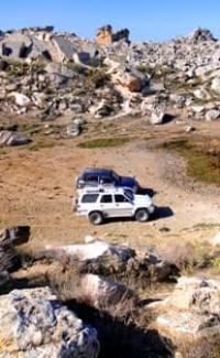
Sightseeing tours on Mangyshlak.
"Having climbed Ak-Dzhul, we saw a beautiful picture. In the west, the black, gloomy Kara-tau chain was visible, framed by chalk formations, in the northeast, the sea was visible, namely, the Chaganak Gulf (the southern part of the Kaidak Gulf), and in the east, the high mountain plain of Ustyurt opened up."
"Through Mangyshlak and Ustyurt to Turkestan." Barbot de Marni. 1889.
Trip to Karatau mountains on Mangyshlak.
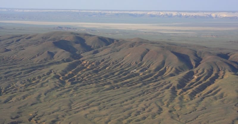
Meridional Karatau ridge is located in central part of Mangyshlak Peninsula in southern part of Kaushe Mountains, in northwest of Southern Aktau ridge, south of Sarytash Gulf in Tyub-Karagan and Mangistau districts of Mangistau region.
The Karatau Mountains stretch from east to west, to the south and further to the southeast for 14 kilometers, their width in the central part reaches 4 kilometers. For 9 kilometers from east to west, the mountains on the southern side are more reminiscent of a chink plateau that rises to the north.
The Karatau plateau consists of a very simple system of ridges: in the center there is a ridge, and along it from the north and south stretch the Aktau ridges - Northern and Southern. The surface of the Karatau ridge has the appearance of a wavy plateau 3 - 9 kilometers wide with preserved peaks-outliers here and there.
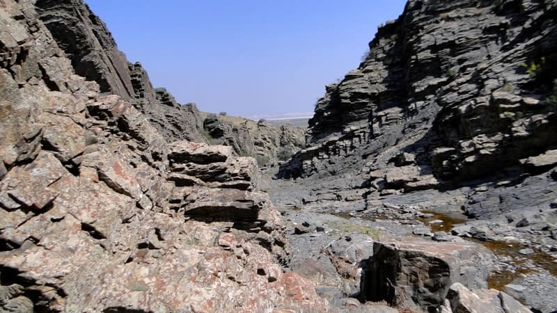
The plateau is cut by numerous ravines-says, which have steep, sometimes sheer slopes. The Karatau Mountains have very steep slopes, almost sheer in places. Parallel to the southern slope of the Karatau, the Southern Aktau stretches to the southeast - a narrow ridge, steeply breaking off to the west and to the north, it is also cut by through ravines-says.
The Karatau and Aktau mountains are separated by depressions - "valleys". The northern valley has a very complex relief. At its bottom, parallel to Karatau, there are several rows of low ridges with steep southern and gentle northern slopes 20 - 40 meters high.
These are outliers, often having bizarre outlines. The relief of the southern valley is simpler, there are almost no ridges of outliers here. In the western part of Ustyurt, among the Miocene deposits of clay and limestone, a mountain range (of a later Jurassic deposit) suddenly appears.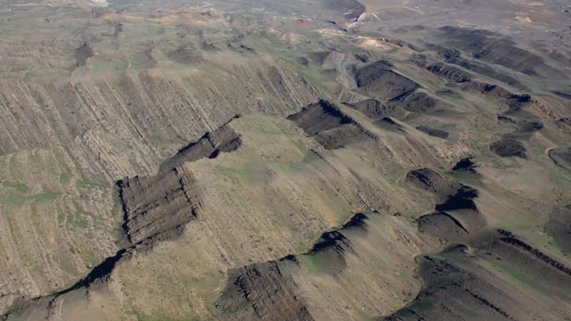
From here it stretches for 200 kilometers to the southeast in three almost parallel rows, rising in places above sea level to 600 meters above sea level. The longer mountain range, the one to the north, is called Northern Aktau (northern white mountains); the one on the far right is Southern Aktau; between them rises the central ridge of Karatau (black mountains).
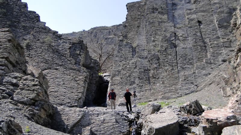
All these mountain ridges are cut by ravines, gorges and hollows, along which turbulent streams run down in the spring, and in places, in small gullies and hollows, snow water stands for quite a long time. Grass grows around them, and sometimes you can even find mulberry near the springs.
The geological characteristics of these mountains are very different. If Aktau are white and consist mainly of chalk, white sandstone, lime and alabaster, and rise no higher than 200 meters, then in Karatau dark colors predominate, as their name indicates.
This mountain range looks more powerful, reaches a height of 600 meters, and the rocks of which it consists are much more diverse - thick layers of asp and slate are found here: red, black, yellow, gray and other colors; there are granite and various crystalline rocks, layers of iron ore, in several places there are multi-colored dyes, deposits of coal, etc.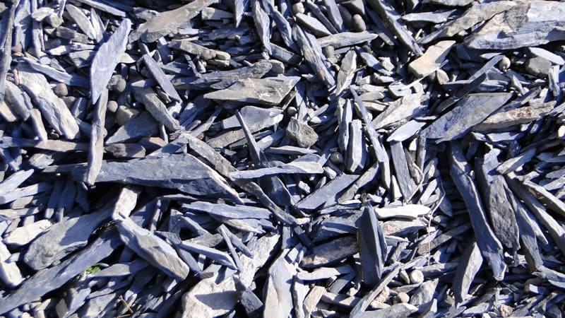
This area is the result of mountain-forming processes, probably accompanied by volcanic eruptions in that distant time when there was a huge sea basin there, not divided by today's Ustyurt into two seas - the Caspian and Aral. Although these mountains are devoid of vegetation, the valleys are scorched by the sun, and camels and other domestic animals have difficulty obtaining food for themselves, people have always lived here.
Even now, small Kazakh auls can be found, but very rarely: two or three yurts located near small springs. The base rocks come to the surface in the center of the highland, forming the low-mountain ridge of Karatau. The mountains are composed of sandstones, limestones, marls, clays and sands. Wormwood-saltwort vegetation with shrubs. Valleys and ravines are used as pastures.
Geographic coordinates of Karatau mountains: N44°22'09 E51°11'46
Authority and photos by:
Alexander Petrov.
“Steppes will come to life.” Anatoly Kostenko, Esbol Umirbaev. Alma-Ata. “Oner.” 1984