


![]()
You are here
Peninsula Mangyshlak.
Traveling around Mangyshlak Peninsula.
"I do not know of any other place where anyone lives, except perhaps Siyakh-kuh, a tribe of Turks lives there, they recently settled there because of the feud that arose between the Guzes and them; they moved away from the Guzes and made a haven for themselves; they have springs and pastures there"
Arab geographer Al-Istakhri. IX century.
Tours on Mangyshlak Peninsula.
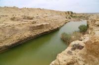
Mangyshlak Peninsula is located on eastern coast of Caspian Sea. In north it borders on Komsomolets Bay and Dead Kultuk salt marsh, in northwest - on Mangyshlak Bay, in south - on Kara-Bogaz-Gol Bay, and in east - on Ustyurt Plateau. Administratively, peninsula covers territories of three districts of Mangystau region: Turkmen, Karakiyan and Mangystau.
Geographically, Mangyshlak is located between 45° and 42° north latitude. Its area is 166.6 square kilometers. The highest point of the peninsula is Mount Besshoku (556 meters above sea level), and the lowest place is the Karagiye depression, reaching -132 meters.
The length of the peninsula from northwest to southeast is 390 kilometers, and its width is about 160 kilometers. The central part is occupied by the Mangyshlak Mountains, to the west of which is the Tyub-Karagan Peninsula with a plateau-like relief reaching a height of 192 meters.
The southern part of Mangyshlak is surrounded by the stepped plateaus of Mangyshlak and Kendyrli-Kiyasay, as well as some of the deepest depressions in Kazakhstan - Karagiye (-132 meters), Karynzharyk (-70 meters) and Kaindy (-57 meters).
In the north is the Buzachi Peninsula, consisting mainly of sedimentary rocks. Its territory is rich in salt marshes, clay plains, and deserts with rocky and wormwood areas. The length of this flat territory from west to east is 210 - 220 kilometers, and the height reaches 61 meters above sea level.
Landscapes of the Mangyshlak Peninsula.
The Mangystau region includes not only the territory of the Mangyshlak Peninsula, but also a significant part of the Ustyurt Plateau, as well as the southern part of the Caspian Lowland, including the Buzachi Peninsula. The total area of the region exceeds 16 million hectares, representing vast natural zones of deserts and semi-deserts.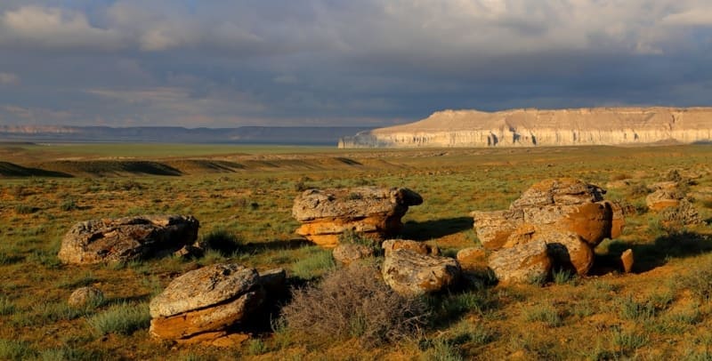
Several characteristic landscapes stand out within the region:
the coastal zone of the Caspian Sea with numerous canyons and ravines;
the Karatau mountain range;
chalk and limestone cliffs (chinks) and remnant mountains;
sand massifs;
clay and saline bottoms of dried-up lakes;
deep depressions.
Tree and shrub vegetation is extremely rare here. The Mangyshlak Peninsula has a virtually bare surface, making it a unique natural "geological museum" for studying sedimentary rocks.
History of Mangyshlak Peninsula.
The first mention of Mangyshlak dates back to the IXth century, when the Arab geographer Al-Istakhri called it Siyah-Kukh, which means "Black Mountain". In his notes, he noted that a Turkic tribe settled in this territory, forced to leave their native lands due to a conflict with the Guzes.
This tribe was probably one of the branches of the Pechenegs, who, having suffered a defeat at the hands of the Guzes, left the lands between the Aral and Caspian Seas and moved to Mangyshlak. Later, the Pechenegs on the peninsula were replaced by the Oguzes, who in some sources are called Turkmens.
The Turks who lived in Mangyshlak later became known as Mangyshlaks. This is also evidenced by the record of Ibn Najib Bekran, where he indicates that the Mangyshlaks are a Turkic tribe forced to move beyond Siyah-Kukh (Mangyshlak) after a feud with the Guzes.
They found sources of water and pastures here, settling on this land, and their ruler was called a khan. In the Xth century, the geographer Ibn Hawqal mentioned the defeat of the Khazar Khaganate by Prince Svyatoslav, after which some of the Khazars moved to Siyah-Kukh.
Later, the Central Asian scholar Abu Rayhan Biruni and his predecessor Muqaddasi wrote about the existence of the port city-fortress of Binkishlak on the peninsula. In 1065, the Seljuk Sultan Alyp Arslan subjugated the Kipchaks, who had settled in the fortress of Mangyshlak.
It was mentioned as an important fortification on the border of the Khorezm lands. in the XIIth century, the traveler Yakut described its location between Khorezm, Saksin and Russian lands, not far from the sea into which the Jeyhun River flowed.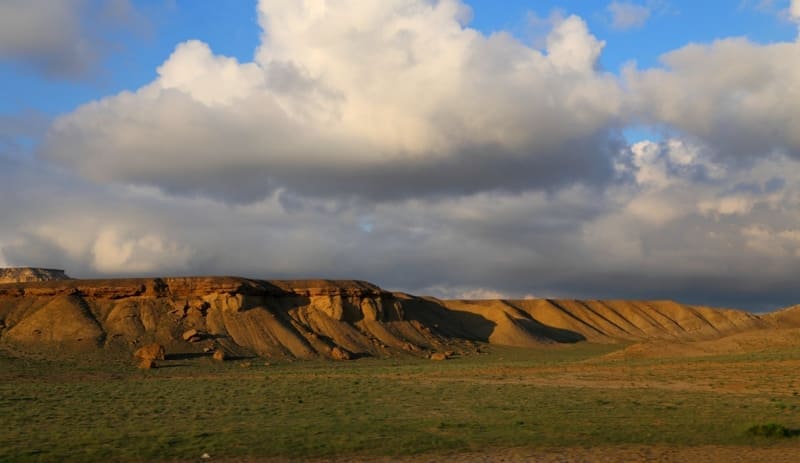
According to academician Samuel Gottlieb Gmelin, a member of the Royal London and Dutch Harlem Societies, the word "Mangyshlak" translated from Tatar meant "famous place". In the Geographical and Statistical Dictionary of the Russian Empire, compiled on behalf of the Russian Geographical Society, this term was explained as "winter camp of the Menks or Nogais", where "menk" is the name of one of the Nogai tribes, and "kishlak" is wintering.
In his work "Journey through Central Asia" Armin Vambery gave a different interpretation, calling Mangyshlak by the ancient name "Ming-kish-lak" - "a thousand winter quarters". In 1871, the interpreter of the geologist P. Doroshin suggested that this word could mean "nomadic camp, lowland." And the professor of the St. Petersburg University V. V. Grigoriev interpreted it as "A thousand nomadic camps." These hypotheses were presented by P. Doroshin in the article "Geological Notes on the Mangyshlak Peninsula," published in the "Mining Journal" in 1871.
Relief of Mangyshlak Peninsula.
The Mangyshlak Peninsula is represented mainly by shell plains, salt marshes-sors, as well as low mountain ranges Aktau ("white mountains") and Karatau ("black mountains"), covered with desert, semi-desert and steppe vegetation. The western part of the peninsula is occupied by the Ustyurt Plateau, reaching a height of 370 meters and limited by steep cliffs - the so-called "chinks."
Another significant part of the relief is the Tyub-Karagan plateau. In the Soviet era, Mangyshlak was often called the "treasure peninsula" due to its rich deposits of oil, gas and other minerals. The history of the peninsula is also associated with the name of the great Ukrainian poet Taras Grigorievich Shevchenko, who, having been exiled for his revolutionary poems, spent seven years in the Novopetrovsk fortification - today's Fort Shevchenko.
Climate of Mangyshlak Peninsula.
The Mangyshlak Peninsula is located in an arid zone, where there are no open fresh water bodies. The arid climate is characterized by high air temperatures, little precipitation and significant evaporation, which is typical of desert and semi-desert regions.
The average annual precipitation is 100 - 160 mm, and its distribution is uneven: the maximum falls in the spring. In some years, precipitation can reach 250 mm, but sometimes it drops to 50 mm. Evaporation exceeds precipitation by almost 10 times.
Winters are cold and snowless, with temperatures ranging from –2 to –6 °C in January. Snow cover is usually thin (3–7 cm) and unstable, forming in December and melting at the end of February. In summer, temperatures reach 26–28 °C, and on the hottest days can rise to 47 °C.
The region is exposed to strong winds, which blow about 90 days a year. In winter, easterly and north-easterly winds prevail, in summer – northerly and north-westerly winds. Dust storms occur 5–6 times a month with wind speeds above 10–12 m/s.
The proximity of the Caspian Sea influences the climate, softening summer and winter temperatures. Thus, in the area of the Akkuduk meteorological station in the Karynzharyk depression, the average July temperature is 28 °C, the maximum is 47 °C, while on the coast these figures are slightly lower - 26 and 43 °C, respectively.
In winter, the minimum temperature in the interior of the peninsula can reach -34 °C, while by the sea it is -26 °C. The frost-free period near the coast lasts about 200 days, and away from it it decreases to 180. The relative humidity of the air near the sea is 60%, and inland it decreases to 40%.
On the contrary, sunshine increases from 2500 hours per year on the coast to 2700 in the Akkuduk area. According to climatic characteristics, Mangyshlak is divided into two parts, the border between which runs approximately along 43° N. Since 1960, the peninsula has become an important area of the oil and gas industry of Kazakhstan, which has led to the intensive development of cities, the main one being Aktau.
Geographic coordinates of Mangyshlak Peninsula: N44°12'51 E51°16'28
Authority:
Sh. Nurmukhambetov. Brief encyclopedia "Kazakh SSR", 1990, 2 volume.
Authority and photos by
Alexander Petrov.