



You are here
I. A. Chekaninsky about Ruins of Kyzyl-Kensh.
Tours to ancient monuments in Kazakhstan.
"In the Ken-Kozlan Mountains, on the Kyzylsu River, which flows into the Talda, in a delightful location stands a two-story stone building, cross-shaped, constructed of wild rock and lime. The ceilings have collapsed, but it is noticeable that they were once painted red, and the walls were plastered. On the upper floor, a gallery and pediment surrounded the entire structure, supported by four wooden columns painted with mastic, which protected them from rot. There were other buildings near this one, but they have fallen to the ground, the walls overgrown with rose hips and meadowsweet of remarkable size."
Levshin, A.I., "Description of Kirghiz-Cossack or Kirghiz-Kaisak Mountains and Steppes." 1832.
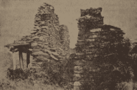
"The palace consisted of a large chamber, 5 sazhens wide and long, with smaller rooms attached to the right and left, and a larger room at the rear." Currently, only the front wall, about two and a half sazhens high, and columns four to five arshins high remain. The side walls of the building and the walls separating the large room are half-collapsed. It is said that several years ago, the log roof was still intact. There was probably a garden with a small pond and irrigation ditches in front of the palace."
N. Konshin. "Memorial Book of Semipalatinsk Region." 1901.
"A Dzungar Khan sought the hand of the daughter of a Khan who lived along the Zhayik (Yaik) River. A young woman, accompanied by her dowry and a large retinue, set off to join her betrothed. However, near the Kent Mountains, the ground became so icy that continuing the journey proved impossible. Consequently, her retinue constructed a palace for her, where she spent the winter.”
N. Konshin, “From Pavlodar to Karkaralinsk,” in *Yearbook of the Semipalatinsk Regional Statistical Committee for 1901* (Semipalatinsk, 1901), Vol. III, pp. 54–55.
Trip from Karaganda to Balkhash.
Karkaralinsk District, Kazakh ASSR.
In the Karkaralinsk District of Kazakhstan 45 km southeast of the town of Karkaralinsk, at the Kyzyl-Kensh site on the western side of the Kent Mountains lie the ruins of a stone structure known to the local Cossacks as “Kensh” or “Kyzyl-Kensh.”
It is situated in a small valley enclosed by rocky elevations; in the northwestern section, these elevations form a passage leading into the expansive valley of the Taldy River, near the Kyzyl-Kensh spring. As early as the beginning of the XIXth century, the building was already in a dilapidated state.
It contained several rooms, with remnants of wooden elements specifically, vertical posts or columns that had once supported a ceiling (a framework of poles). Stones from the southern wall which adjoined the ceiling and rose high above it had collapsed onto this structure.
In 1928, during our visit to Kyzyl-Kensh 1, only two pillars remained; these supported the roof (ceiling) and walls, which were constructed from slabs of local pink granite likely brought from the rocky mountains surrounding Kensh held together with clay.
Near the ruins, on the opposite side of a spring, there is a group of graves covered with scattered granite boulders. The condition of these graves suggests that they have been partially looted by local inhabitants. The location of Kyzyl-Kensh tucked away in a secluded yet picturesque spot within the Kent Mountains indicates that the site either served a strategic purpose for its inhabitants or functioned as a place of religious worship.
In any case, the architectural character of the structure, the layout of its annexes, and the nearby graves suggest that the building existed well before the arrival of the Cossacks in the Karkaralinsk district. The arrival of the Cossacks in this region is known to have occurred between the second half of the XVIIth century and the first half of the XVIIIth century a time when the territory was part of the Dzungar Khanate and inhabited by Kalmyks.
According to data gathered by an expedition tasked with surveying the Steppe regions, the Karakesek clan of the Kazakhs arrived here from Turkestan in 1728, while members of the Zhagaybayly clan -part of the Junior Horde appeared in the Kent Mountains as early as the end of the XVIIth century.
Nevertheless, the remaining The ruins, given the wooden elements still present within them, do not represent a site of great archaeological antiquity; chronologically, they should be dated to no earlier than the beginning of the XVIIth century. At the same time, in the valley of the Kyzyl-Kensha spring, there are burial mounds (kurgans) that appear to belong to a significantly earlier era; according to V. N. Nikitin, some of these mounds were topped with stone statues featuring carved faces and full-body representations.
Unfortunately, we did not discover any artifacts within the Kensha ruins that would sufficiently characterize the culture of the site’s former inhabitants. However, we know from N. Ya. Konshin that Cossacks had, at various times, found small, white-clay objects here conical in shape, with a widened base and a rounded top decorated with patterns.
One such object, currently held in the Semipalatinsk Museum, bears a striking resemblance to certain terracotta figurines found in Central Asia, which were associated with the emergence and spread of Buddhist teachings in that region. It is, in fact, hypothesized that Buddhist communities existed in Semirechye as early as the IInd century.
Furthermore, during that same period (specifically between 628 and 645 AD), the Buddhist monk and traveler Xuanzang visited Central Asia. Having explored the eastern and southeastern parts of Semirechye, he encountered Buddhist monasteries in Eastern Turkestan, where the monks among other activities produced small religious trinkets, which they distributed among the credulous nomadic peoples as a means toward their salvation.
In Semirechye (comprising modern-day Kyrgyzstan and parts of southern and northeastern Kazakhstan), numerous traces of Buddhism including monastery ruins, religious-mystical formulas (such as "om mani padme hum") carved into rock faces, depictions of the Buddha, and Buddhist shrines that existed until relatively recently can be found in many locations: in the Issyk-Ata Gorge, near the medicinal springs (formerly in the Pishpek District); 9 in the Chuy Valley, near the villages of Sokuluk and Belovodskoye (in the same district); 10 near the village of Pokrovskoye, on the rocks along the Juuku and Tamga rivers (formerly in the Tokmak District); 11 on the southern shore of Lake Issyk-Kul, in the Ak-Terek tract within the Duvana Gorge; 12 at the entrances to the northern gorges of the Ala-Too mountain range (part of the Tian Shan system); 13 one kilometer from the Dungan settlement of Mariinskoye (formerly in the Przhevalsk District), on boulders near a mill; 14 on the rocks of the Arasan Mountains (formerly in the Kegen Volost, within the Narynkol-Charyn sector of the Zharkent District); 15 along the border between the Kulja province of Western China and the former Zharkent District of the Semirechye Region, by the frontier river Syumbe, lies the "Syumbe" Buddhist monastery; and in the Naryn Gorge, near the border with Kashgar, are the ruins of what is presumed to be a Buddhist monastery, "Tash-Rabat."
According to accounts from the Chinese, the ruins of an ancient tomb known as "Ak-tam" located between Karakuldek (at the confluence of the Khorgos and Ili rivers, on the border between Western China and the USSR) and the town of Zharkent (20 km from the latter) belong to a Kalmyk lama named Noin Kambu, who was interred there.
A structure resembling a Buddhist shrine was built over his grave. The same Chinese sources claim that as many as a thousand clay burkhans (Buddhist icons) could once be found within the tomb. According to Academician Falk (1771), there was a Kalmyk monastery called Tsagan Suma near the Ili River, by the Dergalang (Jergalan) stream; it housed a life-sized "copper male idol."
Another monastery was situated on the left bank of the Ili, near the Kainukh stream 16 from the first and featured a beautiful garden as well as a copper female idol, similar to the first one.It was called Maidare. When the Chinese drove out the Kalmyks,Falk notes, "these idols were smashed though it is unknown by whom: the Chinese or the Bukharans."
There was a Buddhist shrine at the mouth of the Talgar Gorge in the Trans-Ili Alatau; Buddhist inscriptions and images can be found on the "Tamgaly-Tas" rocks along the Ili River (25 km downstream). Furthermore, such traces exist on the river’s riverside cliffs within the Taigak Gorge located 68-70 km from the settlement of Iliyskoye and 45 km upstream from the Chingildinsky picket, on the right bank of the Ili, in the Chulak Mountains (formerly part of the Kopalsky District). 23 In the Terekty Gorge, southeast of the settlement of Dzhangyzagach (also known as Shcherbakovsky, in the same district); at a distance of 28-30 km from the Kara-Bulak station and 5-6 km upstream from the village of Karatalskoye along the Karatal River (in the same district).
In the Semipalatinsk District: there was a shrine near the Barlyk medicinal springs; a shrine was also located near the Rakhmanov springs; the monastery of Ablai (Ablaikit) was situated 75 km southwest of the city of Ust-Kamenogorsk, along the Ablaikit River, which flows into the Irtysh; five days journey to the west of Ablaikit lay the monastery of Uchuchty-Taishi-Kit built around or shortly after 1672 by Uchuchty-Taishi-Khan, the elder brother of Ablai which was subsequently destroyed by Galdan.
It is extremely difficult to pinpoint this location today, but it must have been situated near the western border of the Semipalatinsk and Karkaralinsk districts. This would be, approximately, within the former Mendeshevskaya or Dosovskaya volosts, in the vicinity of the Salbyr-Kurgan-tas and Urbata-Kadyr mountains -possibly even within the Chingis Range, which lies to the west-southwest of Ablai-Kit.
Furthermore, there is the Bushukhtu-Khan-Kit monastery, built by Galdan (Bushukhtu Khan) around the same time (1676); it was located a six-day journey southwest of Ablai-Kit, near Lake Zaysan, and was destroyed by the Kalmyks in 1689. The exact location of Bushukhtu-Khan-Kit is also currently impossible to determine.
It is difficult to say. It is possible that its location should be sought along the northeastern slopes or foothills of the Tarbagatay range, where as late as the 1850s there existed unexplored ruins of unknown origin. Furthermore, about 185 kilometers from the point where the Irtysh River flows out of Lake Zaysan (near the Karakas settlement landing), on the left bank three kilometers downstream from the Baty landing there stood a shrine as late as the 1860s.
This was evidently associated with the Chinese outposts of Khoni-shal and Mailakh, which were once situated there. The shrine was undoubtedly Buddhist, as it is known that the personnel of these Chinese outposts were typically drawn from local Mongol tribes who practiced Buddhism.
Fifteen kilometers upstream from the Old Semipalatinsk Fortress, on the right bank of the Irtysh River, stood the Erkhe-Tsordzhi (or Tsordzhin-Kit) shrine. There is also a vague reference to the discovery of Buddhist ritual objects specifically bronze statuettes in the Chingistau region, within the Konur-Auliye cave along the Chagan River, located in the Ak-Tas mountains at the Dogolak site.
On the left bank of the Irtysh, 160 kilometers downstream from Semipalatinsk, at a place called Kaban-Gusan, there was the Kolbasinskaya shrine referred to by the Russians as the "Kalbasun Tower" and by the Kalmyks as "Dzhalik-Obo." Thus, according to these data, the region where Buddhism spread encompasses a vast territory bordering Western China and Mongolia that includes parts of Kyrgyzstan and the northern and southeastern regions of Kazakhstan.
This area spans the Kegen Range of the Tian-Shan, Lake Issyk-Kul, the Chu Valley, the Alexandrovsky Range, the northern gorges of the Trans-Ili and Terskey Alatau, the Ili River valley, the Terekty Gorge, the Karatal River valley, the Barlyk mountain system, the northern slopes of the Tarbagatai, the southwestern slopes of the Altai, the Zaysan Basin, and the upper valley of the Irtysh River.
As for the Karkaralinsk district, the existence of Buddhist communities there prior to the arrival of the Cossacks is evidenced by objects related to Buddhist worship and culture that have occasionally been discovered in various parts of the district.
For instance, in 1888, a fragment of an ornamented, fired red brick recovered from a grave in the Kuu Mountains of the Karkaralinsk district was brought to the Semipalatinsk Museum by a Mr. Varaksin. Based on its construction and material, the piece appears to have been part of the standard decorative facing used for Buddhist shrines.
Identical bricks, featuring nearly the same ornamentation, were discovered by us and our companions in 1920 during an archaeological expedition to the Talgar Gorge located 20 km northeast of Almaty where, as previously noted, a Buddhist shrine was once situated.
Another brick, made of grayish clay and featuring a slightly different though more regular geometric pattern, lacks a specific date; however, A. A. Adrianov, the museum director, suggests that it likely originated from the same locality as the first brick.
In a personal conversation, N. Ya. Konshin revealed that in 1902, in Karkaralinsk, he managed to acquire a bronze statuette depicting a seated Buddhist deity. Inquiries among local residents also confirm the discovery of statuettes consistent with Buddhist iconography; however, I was unable to see them personally the items had either been lost by those who found them or were deliberately kept hidden from outsiders.
An examination of the images and inscriptions found on the rocks in the district’s mountainous regions could potentially provide material for further analysis. That said, the rock art discovered thus far in the mountains of the Karkaralinsk district largely falls into the category of picture-based writing a system that remains entirely undeciphered and, given the crudeness of the depictions, likely dates to a relatively late period.
It is also worth noting that N. M. Yadrintsev discovered a stone figure in this district bearing a Turkic inscription in the "Sir" (Orkhon-Yeniseian) script. According to A. A. Slutsky drawing a parallel to Nestorian graves discovered in the Semirechye region this find may date to the IXth-XIVth or XIth-XIIIth centuries.
Thus, it is possible that Nestorian communities once existed here, although N. N. Milyukov does not consider A. A. Slutsky’s hypothesis to be fully substantiated. 40 Objects similar to those discovered in the ruins of Kyzyl-Kensh clay representations of items used in Buddhist worship, known among the Mongols as have been found in large quantities and varying sizes within earthen funerary monuments in Tibet and Mongolia; as is well known, Tibet adopted Buddhism around 640 AD, and Mongolia did so at the beginning of the XVIIth century.
In particular, a striking resemblance can be observed between the clay objects from the ruins of Kyzyl-Kensh and the votive tablets discovered in 1922 by an expedition of the Scientific Committee of Mongolia objects that depict Mount Sumeru.
This similarity is illustrated in the accompanying drawings: one based on a photograph from the expedition’s report, and the other based on a *tsatsa* held in the archaeological collection of the Semipalatinsk Museum. The from Kyzyl-Kensh is fashioned from an off-white clay likely of local origin, given that fragments of fired gray-clay bricks are also found at the site, and the source of this clay exists in the surrounding area.
The measures 43.0 mm in height, with a base diameter of 44.0 mm and a diameter of 54.0 mm at its widest band. According to Buddhist cosmogonical views, the earth is envisioned as a flat plane, surrounded by an ocean, in the middle of which stands the towering Mount Meru, or Sumeru.
Surrounding it are four islands, each possessing its own distinct significance. Sumeru is inhabited by celestial beings who are benevolent toward humanity. These beings are engaged in a perpetual struggle against malevolent entities that dwell at the foot of the mountain.
Forty-two votive tablets depicting this mountain, which is sacred to Buddhists were discovered within stupas near the ruins of the Buddhist monastery of Sardykkiin-Khit. Located in the Ubur-Khatynin-Ama valley in the vicinity of the city of Urga, this site has been identified by V. I. Lisovsky based on the “Erdeniin-Erikhe” chronicle as likely being the monastery built between 1654 and 1680 by Undur-Gegen, the first incarnation of the Jebtsundamba Khutuktu in Mongolia.
The discovery of wheat grains inside the clay artifacts from Kyzyl-Kensh revealed when the objects were broken strongly confirms their ritual function. It is well known that in Buddhist shrines, vessels filled with water, a traditional spirit, rice grains, or barley flour are placed before images of deities as offerings from the faithful.
Unfortunately, there is no record of whether the “tsatsas” found in the “suburgans” of Sardykkiin-Khit also contained wheat grains, nor do we know their dimensions; however, it is clear that the material, form, and decorative motifs (bas-relief ornamentation) of these and the other specimens share a common affinity.
Other features of note are found in the details of the Kyzyl-Kensh structure itself specifically, the carved wooden supports (columns). These may be characteristic of Buddhist architecture, though V. Nikitin and later Dukey Baizhumurov mention these columns without providing any details regarding their architectural style.
Another account concerning these supports or columns notes that they once bore inscriptions. However, during our visit, the two remaining pillars which still hold up the collapsed roof showed nothing architecturally remarkable, nor were there any traces of drawings or inscriptions upon them.
It is highly probable that the original wooden elements were replaced at some point; this is suggested by the fact that, during the time the site was occupied by the Cossacks and specifically when it was held by Zhuldy-Khan and Siil-Khan Kyzyl-Kensh was used as a shelter for livestock during the bitter winter cold and blizzards.
Given the secluded, mountainous nature of the terrain, these modest findings, and the construction, materials, and layout of the buildings, it is reasonable to view Kyzyl-Kensh as a Buddhist monastery. It may well have been a contemporary of the Erkhe Tsordzhi Buddhist temple built in 1648 near the Old Semipalatinsk Fortress and consecrated by the Dzungar lama Zaya Pandita which is believed to have been destroyed between 1660 and 1670 during internal conflicts among the Kalmyks.
Among the local Kazakhs, there exists a legend regarding Kyzyl-Kensh, which recounts in brief that a Kalmyk named Aida-Batyr fell in love with Ilyauke, the daughter of the Kazakh Kasan-Seren-Khan. He abducted her, taking along forty servants and forty young women.
While on the road, having lost his way and fearing pursuit by the Kazakhs, Aida-Batyr stopped in the Kent Mountains, where he built the "Kent Palace" for his betrothed. Before long, Aida-Batyr’s brother, Tleuke-Batyr also hard-pressed by the Kazakhs arrived in the Kent Mountains.
Upon encountering the fugitives, he urged them to join the fight against the Kazakhs; however, Aida-Batyr, prioritizing his own personal well-being above all else, remained indifferent to his brother’s entreaties and was, in consequence, killed by him. Ilyauke and the forty young women perished alongside Aida-Batyr.
With the remaining forty, Tleuke-Batyr engaged the Kazakhs in battle, but in the unequal struggle, he and his were all killed. According to the legend, Tleuke was the last of the Kalmyks. Another, more common version which we heard from a Kazakh named Akan, and which was also recorded by L. K. Chermak as told by a Telengut-Kazakh named Mukhametcha (a native of the Kent Mountains) states that the Kalmyk Khan Ayuke betrothed his daughter, Nedzhe, to another Kalmyk ruler, Khan Kontazhe.
As the bride traveled toward her groom, her retinue included not only forty young women and forty warriors, but also two champions one Kalmyk and one Kazakh. In the Kent Mountains, the wedding procession was overtaken by a harsh winter, and everyone in the party nearly perished from the cold.
To warm themselves up, a Kazakh hero suggested to a Kalmyk hero that they engage in a wrestling match. Having warmed their bodies through the struggle, the heroes gathered firewood, revived their companions, and built a palace for the Khan’s bride, naming it Kyzyl Kench.
When spring arrived, the bride accompanied by the heroes, her handmaidens, and the young warriors set off for the encampment of her betrothed, Khan Kontazhe, and soon reached their destination. However, at the bride’s request, the wedding ceremony was postponed; she had become pregnant by the Kazakh hero during the journey and had informed the Khan of this fact.
In time, the bride gave birth to a son named Alty-Aylyg, which translates to "Six-Month-Old." Placed in the care of slave women, the boy grew with remarkable speed. By the age of nine, he was tasked with herding camels. Alty-Aylyg who remained unaware of his true parentage soon became an expert archer; during a competition organized by the Khan, he proved to be the victor.
The Khan, fearing Alty-Aylyg as a formidable rival to his own son, ordered that Alty-Aylyg’s right collarbone be cut out while he slept; thereafter, the boy could no longer draw his bow with his former strength. One day, Nedje revealed to her son the truth of his parentage.
Seeking revenge against the Khan, Alty-Aylyg killed the Khan’s son with an arrow, seized his fine steed, and set off in search of his true father. Thus, local Kazan tradition attributes the construction of Kyzyl-Kensh to the era when the Oirat-Kalmyks held sway over the region.
Much like other Kazan legends such as the poem "Kozu-Kurpesh and Bayan-Slu" the tale of Kyzyl-Kensh clearly depicts a fierce struggle between two peoples: the newcomers from Turkestan (the Kazakhs) and the indigenous inhabitants (the Kalmyks).
This conflict reflects actual historical events that took place in the Karkaralinsk district toward the end of the XVIIth century. It is evident that the Buddhist-Lamaist temple or shrine of Kyzyl-Kensh served as a direct witness to these historical events; its inhabitants abandoned it whether by force or of their own volition during the upheaval, after which it was looted and partially destroyed by the newcomers.
In conclusion, one must also take note of the name given to these ruins. Local Cossacks refer to them as "Kzyl-Kensh" or "Kzyl-Kench" a name that would translate to "Red City" (though the Russians incorrectly interpret the term "kent" as "palace").
It should be noted that the word "kent" (or "kend") is not of Kazan-Tatar origin; it was likely borrowed from the Persian language. However, if we set aside this interpretation and propose a different theory that at the time of the Cossacks' arrival, these ruins bore the Mongolian name "Khit" (meaning "temple" or "monastery") the linguistic evidence becomes more compelling. In Russian, this term would be rendered as "khit" or "khid" (as seen in names like "Ablai-Khit" or "Zardzhin-Khid"), while in the Kazan-Tatar pronunciation, it would evolve into "kent" or "kensh."
This suggests that the ruins of Kzyl-Kensh are, in fact, the remains of a former Buddhist monastery, rather than a palace, a city, or as previously suggested a fortress built for strategic purposes. The Cossacks may have applied the term "Kzyl" ("red") to the ruins because they were constructed from the reddish-pink granite found in the surrounding area the very stone that forms the massifs of the Kent Mountains, which dominate the Taldinskaya Valley.


Authority and photographs by:
I. A. Chekaninsky. "The Ruins of Kyzyl-Kensh." Karkaralinsk District, Kazakh ASSR.
Research and bibliography. *Notes of the Semipalatinsk Branch of the Society for the Study of Kazakhstan* (formerly the Semipalatinsk Branch of the State Russian Geographical Society). Volume 1, 1929 (Issue XVIII). Semipalatinsk.