


![]()
You are here
Zh. Artykbaev on Kyzyl-Kench Palace.
Architectural Monuments of Central Kazakhstan.
"In the Kent-Kazlyk Mountains, 25 versts from the Karkaraly Outer District Prikaz, on the Kyzyl-Su River, which flows into the Talda, stands a two-story cruciform stone building made of wild stone and lime. The ceilings have collapsed, but it is noticeable that they were once covered with red paint. The walls are plastered. On the upper floor is a gallery, surrounding the entire structure, and a pediment supported by four wooden columns painted with mastic, which protected them from decay."
S.B. Bronevskoy. Governor of the Omsk Region.
Little-known Monuments of Kalmyk Architecture in Central Kazakhstan.
The Kyzyl-Kench Palace is a little-known monument of Kalmyk architecture in Central Kazakhstan. The Great Migration of the Durban-Oirat tribes to the West is an exceptionally remarkable event in the history of Central Asia. In its scale and consequences, it ranks alongside the migrations of the Uzbek-Kazakh tribes from north to south, as well as the movements of the Nogai tribes during the collapse of the Nogai Horde.
All these events, and especially the Great Migration of the Durban-Oirat, are directly related to the history of Kazakhstan; the degree of study of this process determines the objectivity of the picture of the past of the Kazakh people. We tend to consider the causes and nature of these migrations in the general context of the Great Migrations of the nomadic peoples of Central Asia.
Until the early XVIIth century, the Durban-Oirat people remained surrounded by several ethnopolitical systems - Moghulistan, the Kazakh Khanate, the Eastern Mongolian Union, and so on. The Oirats likely felt the most serious pressure from the East, from their close relatives - the Eastern Mongol tribes. In 1552 and 1562, the Oirats suffered several major defeats at their hands, abandoning their ancestral pastures on the Orkhon River, at the source of the Irtysh River, and retreating west.
As a result, individual groups of Oirat tribes, located closer to the Kazakh nomadic camps, submitted to the Kazakh Tauekel Khan. In Russian-Kazakh correspondence from the late XVIth century, Tauekel Khan is referred to as the "King of Kazakh and Kalmyk."
The Kazakh envoy Kul-Muhammad, while in Moscow, informs Orazmuhammed, Tauekel Khan's brother:
"Now your uncle Tevkel... has placed his brother Shahmagmet, the prince, on the kolmaks, and they are wandering in blisk and all united..."
The sources do not indicate which Oirat groups joined the Kazakh union; they were likely the Derbeto-Khoshout uluses. The peace that came during the reign of Tauekel Khan was temporary. Serious events were brewing in the northeastern regions of Central Asia, in the Manchu nomadic camps. In 1636, Abahai, having defeated the largest holdings of the western and southern Mongols, achieved the proclamation of himself as the 135th Khan of Mongolia, with the title "Bogdo Khan."
Following this, the Manchus declared the complete subjugation of the Durben-Oirats as well. This marked the beginning of a new stage in their westward movement. During this migration, the remaining uluses consolidated into a single powerful state.
The majority of the Durben Oirat Union faced a difficult choice: either follow the Torgout KhoOrlyk westward in search of free territories or remain with the Dzungars led by Batur Khuntaiji. At the same time, in the early XVIIth century, the Durben Oirat tribes adopted Buddhism, which became a significant factor in the consolidation of the Western Mongolian tribes.
Apparently, with the participation of the lamas, the All-Oirat Congress of 1640 was convened, which adopted the so-called Mongol-Oirat Laws, or "Ikh Tsaaz." During the fierce clashes of the 1630s, the western group of Oirats, the Torgouts, occupied the area between the Volga and Ural rivers.
The Derbets, led by Dalai Taiji, remained in the steppes of the northern Aral Sea region due to a series of disagreements with the Torgout rulers (primarily Kho-Orlyk). Slightly east of the Derbets, in the regions of Central Kazakhstan, lived Khoshout groups led by Kundulung-Ubashi.
Further east, closer to the Irtysh River valley, were the Khoshouts of Abylai Taiji, Ochirtu Tsetsen Khan, and others. Thus, as early as the 1830s, a Kalmyk corridor emerged along 48 - 52 degrees latitude, which subsequently became a route of intensive contact for the Durben-Oirats.
Undoubtedly, the migratory activity of the Oirats and the resulting corridor had a strong negative impact on the traditional economic and cultural system of the Kazakhs. The main meridional migration routes of the Kazakh tribes were interrupted over large areas.
Kalmyk pressure was one of the main reasons for the compaction of Kazakhs in the southern regions, as well as in East Turkestan. This period is known not only for the constant clashes between the Kazakhs and Kalmyks, but also for examples of good neighborly relations.
For example, in 1635, the Dalai Taiji fought against the Torghuts in alliance with the Kazakh Khan Jangir, and in 1643, despite threats from Batur Khuntaiji, Kundulung "did not go to war against Yangir and Yalantush himself and did not send his men, but stood by Yangir."
As they developed the Volga region, simultaneously opening the way to the North Caucasus and the Azov region, the Oirats gradually began to liberate the northern lands they had occupied from the Kazakhs in the late 17th century. However, during the period of Oirat dominance, many Buddhist structures appeared in this area.
Relatively much is known about some of them. Among those noted by many researchers are the Ablain-kit (Abylain-sume in the "Biography of Zayapandita"), Zordzhin-kit (Dorgan Zordshin, Darkhan-tsorzhdi), and other temples. Although even here, many unanswered questions remain.
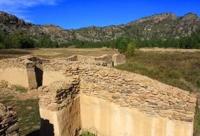
This is especially true of Darkhan-tsorzhdi, one of the earliest monuments. A lesser-known monument is the Kyzyl-Kench Palace, or temple, located in the Karkaralinsk-Kent Mountains region of Central Kazakhstan. While still a history student at Karaganda University, in 1983, I dedicated a short article to this unique piece of Kalmyk architecture.
My interest in this monument was sparked by stories told by elderly Kazakhs who lived in the village of Kent, not far from the temple ruins. In that student article, I first attempted to reconstruct the appearance of this structure, based both on my observations and on descriptions by V.N. Nikitin and I.A. Chekaninsky. Later, A.K. Abilev, head of the Department of Kazakhstan History at Karaganda University, and Zh.E. Smailov (then a budding archaeologist) became interested in this monument, and as a result, excavations began in 1986.
The excavation materials confirmed our assumption that this structure was one of the large Buddhist temples in Central Kazakhstan. As early as the mid-19th century, Kyzyl-Kench was a prominent architectural monument, noted by many scholars and travelers.
First mention of it was by S.B. Bronevsky, governor of Omsk region. He writes:
"In the Kent-Kazlyk Mountains, 25 miles from the Karkaraly Outer District Prikaz, on the Kyzyl-Su River, which flows into the Talda, stands a two-story, cruciform stone building made of wild rock and lime. The ceilings have collapsed, but it is noticeable that they were once covered with red paint, the walls are plastered, and on the upper floor is a gallery surrounding the entire structure and a pediment supported by four wooden columns painted with mastic, which protected them from rot.
There were others near this building, but they have crumbled to the ground; the walls are overgrown with rose hips and meadowsweet trees of remarkable size. he Kirghiz (Kazakhs - Zh.A.) worship this place, and I found various offerings of them there, made of scraps of cloth, bones, and remains of horsehair."
S.B. Bronevsky conducted a small excavation near the palace, likely uncovering several burial mounds dating to the Bronze Age and the Old Turkic period, of which there are numerous in the area. All finds were sent to the office of Count Nikolai Petrovich Rumyantsev. V.N. Nikitin played a significant role in the study and description of the Kyzyl-Kench Palace.
Here is his description: "Along the Kyzyl-Kench spring in the eastern part of the Kent Mountains, there are 21 burial mounds resembling yurts, some large, some medium-sized, both with depressions an arshin or more deep at the top, or stones and babas with carved faces and entire figures.
Near this same spring in the tract of the same name are the ruins of a building, popularly known as the Kent Palace. This building is small, exceeding 5 sazhens in length and width. On three sides - the north, east, and west - small rectangular annexes of varying sizes adjoin the building.
These annexes have no external appearance and are each connected to the main building separately by internal passages, each one 1 arshin 1.2 vershoks wide and 2 arshins 1 vershoks high. It is impossible to judge whether the annexes or the building itself had windows, as the walls are heavily damaged and currently stand a little over 100 yards high, with the exception of the south side, where the wall reaches almost 8 arshins.
The entrance, 2 arshins wide and 2 arshins 1.2 vershoks high, is constructed under a canopy. The canopy resembles a balcony and is supported by six wooden posts, each up to 4 arshins high. Two posts are located near the wall of the house, on either side of the external entrance, and support the canopy along the edges of the wall: two at the corners and two in the middle.
On the two rear and four front posts, a log is placed, with decorative mats underneath the logs on the two outer corner posts; on these logs, the thickness of which is equal to the posts, 17 poles of medium thickness are placed across them. The space between the poles is filled with planks 5 - 7 vershoks long, 1 vershok wide, and Half an inch thick.
Their ends are hewn to ensure a more stable resting on the poles; on top of these planks, weighing them down, are more poles, and on them are stone slabs, earth, and various debris. On both sides of the canopy, some remains of walls are visible.
Whether these walls were an extension, like those on the other sides of the building, or a protective entrance is difficult to say, as it is risky to assume that this canopy belongs to the distant past, rather than modern times. Above the canopy, there is a window in the wall, and inside the building, in the same wall, at a height of 3 arshins 7 vershok (1,200 ft), four thin beams protrude from the ground, apparently nothing more than the remains of the main floor of the second floor.
That this building was two-story is suggested by tradition and is confirmed partly by the height of the wall, but mainly by the fact that a window remains in the south wall at a height of over 3 arshins (1,200 ft). The entire building and its annexes are constructed of poorly hewn stone slabs, and judging by the few surviving remains, it was plastered with clay both inside and out.
The walls are heavily damaged, overgrown with sparse grass, but even now, in some places, they are 1 arshin (2 inches) thick. Near the building itself, on the eastern and western sides, are traces of some ruined structures, and a little further away are several graves, which, judging by their appearance, are not Kyrgyz (Kazakh - Zh.A.).
The area where the Kent Palace is located is a small valley surrounded on almost all sides by rocky mountains, which, however, become more gentle to the south, forming a passage to the Taldy River valley from the northwest. In front of the southern face of the ruins, about three or four fathoms away, is a small pond, completely overgrown with reeds.
In the valley south of the pond, small shrubs and occasional small pine trees grow. These become denser and more frequent closer to the mountains, thinning out again and clinging to the rocks in places. This area, along with its ruins, now belongs to the Kyrgyz (Kazakh - Zh.A.).
Aknay has been in the possession of his family for about a century and a half, perhaps more." Let's look at the results of archaeological research in 1986 - 1987, during which the Kyzyl-Kench Palace, with its three separate structures, was completely excavated.
Before the excavations, the palace ruins comprised a mound densely overgrown with grass and rose bushes. Around the main mound (up to 3 meters high), the ruins of individual structures, also overgrown with grass and shrubs, were identified.
On the southeastern side of the mound, two pits of considerable depth (up to 2 meters) were observed. Excavation of the main mound revealed a cruciform structure with four annexes. The walls of the building were constructed of undressed flagstone.
During clearing, a large number of half-decayed wooden planks, poles, and logs were found inside the structure. It was not possible to determine any order in the arrangement of these logs and planks. The southeast side of the main room is 11.6 meters long, the northeast side is 12 meters, the northwest side is 11.8 meters, and the southwest side is 12.2 meters.
Small rooms attached to three sides of the main room have entrances 1.1 - 1.3 meters wide; these rooms have no entrances from the outside of the structure. The walls of the small rooms adjoin the walls of the main room without any masonry bond.
The floor of the main room is coated with white limestone clay. The exception is the eastern corner, where the floor is painted red. The interior walls of the structure, judging by the surviving plastered areas, were covered with white limestone clay.
Ten stone slabs were embedded in the floor of the main room, serving as foundations for wooden pillars supporting the second floor. To install these slabs, pits up to 0.3 meters deep and 0.4 meters in diameter were dug and filled with broken stone mixed with earth.
During the clearing of the vestibule opening, the remains of six wooden pillars supporting the balcony were discovered. The height of the surviving column remains ranges from 0.10 to 0.75 meters, with a diameter of 0.25 to 0.30 meters. The balcony columns, like those inside the palace, were placed on stone slabs.
An ash pit up to 0.15 meters thick was found in the corner of the vestibule opening to the left of the entrance. The ash pit contained nothing but calcified animal bones. The palace entrance threshold is paved with stone. The doorway is 1.3 meters wide.
The surviving palace walls range in height from 1.2 meters to 2.7 meters, and are 0.8 to 1 meter thick. The following finds were discovered during the interior clearance. Inside the main room, at the entrance to the northeast chamber, wooden planks (140 cm thick) were found, featuring geometric, zoomorphic, and openwork plant designs.
The planks are painted red and gold. Also found here were wooden sticks painted red, 1.5 - 3 cm in diameter, and four bronze plates 16.5 cm long, 2 - 2.5 cm wide, and 0.3 cm thick. The plates had three holes, two of which contained iron nails.
In the northeast corner of the main room, a broken mica circle with a hole in the center was discovered. The circle's diameter was 43 cm and its thickness was 6 cm. During the clearing of rubble inside the main room, five beads, 0.6 - 1 cm in diameter, were found in various places.
In the eastern corner of the main room, two lead bullets, 1.2 cm in diameter, were found in the lower layer. Also, during the clearing of rubble inside the main room and in the smaller rooms, a large number of small mica plates were found. An oblong iron lock was discovered inside the northeast small room. It is 16 cm long, 5 cm wide, and 2.5 cm thick.
Five iron clamps up to 8.5 cm long and up to 0.6 cm thick were also found here. In the small northwestern room is a small white stone ornament, 1.5 cm in diameter at the base. The ornament is cone-shaped. In the small southwestern room, pieces of bronze wire and a gun trigger were found.
To the northeast (5 meters from the main structure) were the ruins of a small square building. It was also densely overgrown with grass and shrubs. The orientation is based on the cardinal directions. During clearing, a buried layer was discovered behind the turf layer, extending at a depth of 0.15 meters below the surface.
Along the walls, between the turf layer and the buried layer, there is a clay layer formed by the fusion of the wall's binder mortar. The walls are made of flagstone with clay mortar. The walls are up to 1 meter thick and up to 0.4 meters high. The masonry stones are laid in 2 - 3 layers.
The southwest side of the structure is 11 meters long, the northwest side is 11.5 meters, the northeast side is 11.5 meters, and the southeast side is 11 meters. During cleaning, fragments of pottery made on a potter's wheel were discovered. The fragments are light brown in color and 0.7 - 0.8 cm thick.
The stonework in the center is oval-shaped, with a diameter of 4 and 5 meters. The results of research conducted at the Kyzyl-Kench Palace indicate that it functioned as a permanent human habitation and a cult center for only a short time. The insignificant cultural layer, consisting of a small ash pit, a small number of domestic animal bones, and the absence of household items, speak for themselves.
Kyzyl-Kench was inhabited only sporadically. The question of identifying the owners of this grandiose structure is more complex. The idea that this monument is of Oirat origin and that it bears clear traces of Buddhist culture has been expressed for a long time.
But who initiated the temple's construction, and during what period did it function as a cult center? This question was first raised as a working hypothesis by S.S. Chernikov. Based on K. Ritter's report, he suggested that the temple was built by Uchurtu Khan.
"The Kent Palace is probably Uchurtu Khan-Kit," writes S.S. Chernikov. Miller's materials, according to the author, contain information that Uchurtu Taisha built a temple five days' journey west of Ablai's domain, which was later destroyed by Galdan-Boshokhtu.
The hypothesis proved untenable. Moreover, Ablai did not live permanently in the temple he built, and his domain was quite extensive (from the Altyn Emel (Emil) River to the middle reaches of the Irtysh River). Therefore, making an exact calculation is nearly impossible.
Furthermore, if the text refers to Ochirtu Tsetsen Khan (according to S.S. Chernikov-Uchurtu), it is known that he indeed fought against Galdan Boshoktu in 1676 (the Year of the Snake) in the Shara Bel area, near Lake Kapchagay on the Ili River.
At that time, Ochirtu Tsetsen Khan was nomadic in the upper reaches of the Ili River (from Zultus downstream of the Kunges River). This hypothesis was relied upon by Zh.E. Smailov in his interpretation of the history of the Kyzyl-Kench Palace.
At the same time, he also hypothesized that the Khoshut ruler Kundulung Ubashi was involved with this temple. However, direct evidence of this has not yet been found in the sources, except for the fact that Kundulung Ubashi wintered in the Kazylyk (Khasulag) area in 1643.
The latter hypothesis likely has a better chance of being objective, but requires some additional explanation. In our opinion, it is important to consider that the Derbets arrived in this area somewhat earlier (i.e., in the 1620s) and their leader, the Dalai Taiji, was the most powerful of the western Kalmyk rulers.
Somewhere in this region should also be the suburgan of Daiching Khoshuuchi, the son of the Dalai Taiji, to which Kundulung Ubashi invited Zaya Pandita. The ruins of the structure located next to the Kyzyl-Kench Palace are likely that suburgan.
References:
1. Kazakh-Russian Relations in the XVIIth - XVIIIth Centuries (Collection of Materials and Documents). Alma-Ata, 1961, Vol. 3
2. International Relations in Central Asia. XVIIth - XVIIIth Centuries. Documents and Materials. Book I. Moscow, 1989.
3. Spassky, G.I. On Ancient Ruins in Siberia. Siberian Herald. St. Petersburg, 1818, pp. 39 - 94.
4. Radlov, V.V. Siberian Antiquities. Vol. 1, issue 3 (with map, 22 tables and figures, and 109 plate pages). St. Petersburg, 1894, pp. 55 - 146;
5. Chernikov, S.S. Architectural Monuments of Oiratkalmyks (Materials). Notes of the KNIIYALI, issue 1, Elista, 1960. pp. 115 - 134 Darkhan-tsorji (or Zordshin-kit) is a temple complex built in early XVIIth century on middle reaches of Irtysh River. It is named after its abbot, Lama Darkhan-tsorji. Many researchers confuse this name with the name of Erhe Darkhan-tsorji, who was a follower and student of Zaya-pandita, which is fundamentally incorrect. Among Oirat tribes, most common name for this temple was "Erchisyn-sume" (before 1658). Sh. Norbo in his book "Zaya-pandita" made a mistake by calling Ablaiin-sume, built in the 1650s, the "Irtysh temple" (Erchisyn-sume). Please note text of "Biography of Zaya - 143 Pandita": "In year of monkey (1644), he (Zaya-Pandita) went to Ochirtu-taiji in the summer... From there, Darkhan-Tsorji asked him to come to temple located on Irtysh (Erchisyn-sume)" (see Sh. Norbo "Zaya-Pandita". Elista, 1999, p. 45). Location of Erchisyn-sume corresponds to the modern borders of Semipalatinsk.
6. Artykbaev Z.O. "Kyzyl-Ketsh saraynyn, zhumbagy". Mysteries of the Kyzyl-Kench Palace. Ortalyk Kazakhstan. 1983. September 19.
7. Nikitin V.N. Ancient Monuments of the Karkaraly District. Notes of IRAO, new series, vol. VI11, issue 1, vol. 2. St. Petersburg, 1896, pp. 43 - 64;
8. Chekaninsky, I.A. Ruins of Kzyl-Kensh in the Karkaraly District of the Kazakh ASSR (Research and Bibliography). Notes of Semipalatinsk Department of Kazakhstan Study Society. Vol. 1, issue 18. 1929, pp. 89 - 103.
9. Notes of Major General Bronevsky on Kirghiz-Kaisaks of Middle Horde. Otechestvennye zapiski. St. Petersburg, 1830, part 43, vol. 10, pp. 247 - 248.
10. Nikitin, V.N. Said work.
11. This section uses materials from "Report on Results of Archaeological Excavations of Kyzyl-Kent Palace." Compiled by Zh.E. Smailov. Karaganda, 1987.
12. Chernikov, S.S. "Oirat-Kalmyk Architectural Monuments/Materials." Notes of KNIIYALI, Issue 1. Elista, 1960, pp. 133 - 134.
13. Norbo, Sh. "Zaya-Pandita: Materials for a Biography." Elista, 1999, p. 115. 12 Ibid.
Authority:
Zh. O. Artykbaev.
file:///C:/Users/User/Downloads/289-457-1-SM.pdf
http://kigiran.com/pubs/index.php/mongolian/article/viewFile/903/882
Photos by:
Alexander Petrov.