


![]()
You are here
Tour to valleys of Saryjaz, Kuylyu, Altyn-Arashan.

rip from Almaty to village of Inylchek.
"Terskey-Ala-tau is wooded up to the Tona gorge, about forty miles west of Barskaun, i.e., at the eastern two-thirds of Issyk-kul; at the western part of the lake it is treeless, except for rare juniper. The coastal strip beyond Dzhity-uguz is already constrained by the bare Urgachar, then reaches a width of 10 miles at the lower reaches of Kyzyl-su and Zauka, and beyond Zauka it quickly narrows again; the low hills at the foot of Terskey-Ala-tau here come to the lake itself, and so, with a short break at the lower Barska-un, continue to the westernmost end of Issyk-kul (But here the longitudinal valley between Terskey-Ala-tau and a small coastal ridge, discovered by Protsenko, may be convenient for Russian settlement; it stretches for about 60 versts from Ton to the Semiz River, is crossed by the Konur-ulen, Alabas, Ulahol and intermediate small rivers and is covered with beautiful meadow grass; timber can be obtained from Ton."
"Travel through Turkestan region and exploration of mountainous country of Tien-Shan." Nikolai Severtsov. 1873.
Trip to upper reaches of Sarydzhaz.
Short description of trip to Terskey Ala-Too gorges:
Almaty - valley and river Karkara - Saryjaz river valley - Kuylyu gorge - Inylchek village and river - Chon-Ashu pass - Turgen-Aksu, Ak-Suu (Teploklyuchenka) villages - Altyn-Arashan gorge - city Karakol – settlement Tyup – town Cholpon-Ata – town Balykchi - Boom gorge - Bishkek city.
Distance of route: 1090 km.
Season: from July 10 to September 1.
Duration of tour: 8 days.
Distance of active part of tour: 17 km.
Best time for tour: July - August.
Detailed program of tour around nature of Sarydzhaz and Kuylyu ridges:
Day 1. Almaty - Char-Kuduk valley (304 km).
Transfer: Almaty - Chilik village - Charyn canyons (210 km, 3 - 3.5 hours).
From Almaty to Chilik village 120 kilometers, we will cover this distance on a new "concrete" road bypassing, populated areas. Passing the village of Chilik, we leave the highway and move towards the Sogety mountains, soon at the bazaar in the village of Baiseit we have our first short stop.
Along the main street of the village stretches a colorful vegetable bazaar, interspersed with cafes, restaurants, barbecue and tandoor. Further path lies through the small Sogety ridge, along the narrow Kokpek gorge, 11 kilometers long. The ridge separates the valley of the Ili River from the large latitudinal ridge of the Zailiysky Alatau.
Gradually, the Kokpek gorge widens and passes into the Syugaty valley, which is fenced from the north by the Sogety ridge, from the south by the Toruaigyr ridge. Syugaty valley stretches from west to east and the extreme northern border of the valley is the Ili River, the southern - Charyn River.
Having passed the valley, the road begins to go deeper into the Alasy gorge of the Toruaigyr ridge, we turn left onto the road leading to the Charyn canyon. From here to the canyon is 11 kilometers. Arrival at Charyn canyons.
Walk along canyon to Charyn River.
Charyn Canyon is a whole ensemble of palaces, towers and minarets. The gorge reached approximately this appearance about half a million years ago. This is how the "Valley of Castles" arose - one of the masterpieces of natural architecture.
On the slopes there are numerous remains of fossil fauna, dating back to the Lower Carboniferous about 300 million years ago. Since prehistoric times, the waters of the Charyn - the largest tributary of the Ili River - have carved a channel for themselves among the rocks, grinding down the stone and forming a huge passage in the rocks.
Charyn Canyon is a unique natural complex of Kazakhstan, has a length of about one hundred kilometers. End of the walk, lunch.
Further transfer: Charyn canyons - bridge over Charyn river - Aksay village - Kegen village (50 km).
Before the village of Chilik, we pass a small mountain range Kuluk-Tau in the eastern part of the Zailiyskiy Alatau with the Kegen pass 1945 meters above sea level. In the village of Kegen, a short stop, visiting shops.
Further transfer: Kegen - Karkara village - Kazakh-Kyrgyz checkpoint "Karkara" 26 km).
Passing through border control formalities.
Transfer: Checkpoint "Kegen" - Kyrgyz village Karkara - Karkara river and gorge - Char-Kuduk valley(18 km).
We will set up our camp on the left bank of the Karkara River. Walking in the surrounding area, dinner, overnight in tents.
Day 2. Char-Kuduk valley - Sarydzhaz river valley (50 km).
Breakfast. Transfer: Char-Kuduk - * Karkara river valley - Kyzylmoynok pass 2801 - Turuk gorge - Turuk pass 3354 m. a. s. l. (47 km).
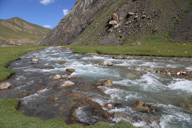
After the Char-Kuduk valley, our path continues up the Karkara gorge. A beautiful, blue river rushes with a roar and rumble in a stone bed. The northern slopes are chosen by the Shrenk spruce, the mighty trees rise to an altitude of 2900 meters above sea level.
After the confluence of the Borondo-Turuk and Chon-Turuk rivers, the Turuk River is formed, in this place on the left bank of the river there are picturesque white outcrops of marble rock. After the confluence of the Turuk and Kokdzhar rivers, the Karkara River is formed.
In the Karkara gorge there are vast jailoos and here are numerous herds of sheep, cows and herds of horses. Almost along our entire journey we will be accompanied by shepherds' camps with yurts and tents. The further way along the valley of the river Turuk, the road here is more difficult and less traveled, gradually we get to the syrts, these are huge swampy areas, overgrown with stunted grass, low bushes with small lakes.
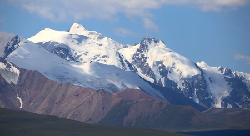
Syrts are open spaces, it is impossible to protect yourself from the wind here, the vegetation is dry and not abundant and shepherds with their flocks are very rare here. Soon we are at the Turuk pass. Not far from here in the area of the Kokdzhar river, in 1856 the tireless and very first explorer of Tien-Shan P.P. Semenov Tian-Shansky first saw the Khan-Tengri peak.
The artist Kosharov was able to sketch this picture. Here the travelers got into severe bad weather, there was a strong snowstorm and their tents were completely covered with snow. On a sunny morning they saw the Khan-Tengri peak. Stop at the pass. From here, a great panorama of the Sary-Dzhaz ridge opens up.
We are located approximately in the middle of the ridge, observing it from the north, from the height of the pass, the northern slope of the ridge, distant and close peaks, as if on the palm of your hand. We hope that at sunset, a pointed pyramid of an amazing mountain will open up before us, which will be removed from us at a distance of 65 kilometers to the east, but a little to the south.
Transfer: Turuk pass - valley of the Sary-Dzhaz river (3037 m. a. s. l.) (3 km).
Soon we descend into the valley of the Sary-Dzhaz river, our camp will be on the right side of the river, opposite the lake Zhashyl-Kol next to the Ak-Chunkur cave.
Walks in the vicinity, dinner, overnight in tents.
Day 3. Sary-Dzhaz - Kuylyu gorge (61 km).
Breakfast. After breakfast, visit to the Ak-Chunkur cave. In the middle of the last century, the cave was interesting because it preserved rock paintings made with red ocher. The finds in the cave date back to the Neolithic period, and the paintings to the end of the Neolithic period or the beginning of the Bronze Age.
The entrance to the cave begins with a large grotto, in which V.I. Ratzek and H.A. Apysbayev discovered paintings in 1953.
Transfer: Sarydzhaz - outpost "Echkili-Tash" - rivers Tuyuk, Kensu, Ottuk (32 km).
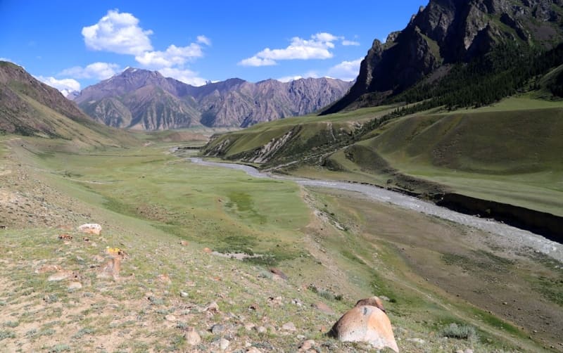
9.5 kilometers from the Ak-Chunkur cave there is a border outpost "Echkili-Tash", here are the border control formalities. The valley of the Sarydzhaz River is extremely picturesque, and we will often see new and new snow-capped peaks and glaciers of the northern slope, located in the main ridge of the range.
We go down the right side of the Sarydzhaz River and will see beautiful and interesting bends and turns of the river against the backdrop of a wide valley and spills. In the summer months, the river flows muddy, filled with suspended matter, only in the fall, when the melting of glaciers decreases, the water becomes clean and transparent with a bluish-blue tint.
Soon we will make a stop where the Ottuk River flows into the Sarydzhaz on the right. This is a very picturesque place, a crystal clear and transparent river flows into the muddy Sarydzhaz. Ottuk originates from the southern slopes of the Terskey Ala-Too ridge, the length of the river is 24 kilometers. Walk in the vicinity.
Further transfer: Ottuk River - Kuylyu gorge - Mola River - Sharkyratma River (28 km).
At the place where Ottuk flows into the Sarydzhaz, the river turns south, on the right side there is a road. The road from Karakol to the village of Inylchek began to be built in 1980. For 8 kilometers our path lies down along the Sarydzhaz River, we reach the Kuilyu gorge and turn onto a country road that goes deep into the gorge.
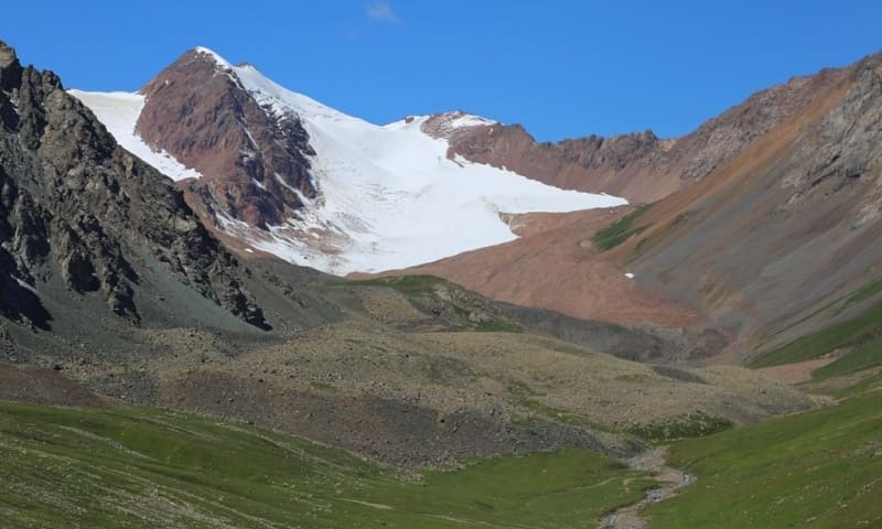
The road runs along the left side of the Kuilyu River, along the northern slope of the gorge. About 12 kilometers later we reach a picturesque place, here is the grandiose Mola Mountain, 3530.9 meters above sea level, which rises on the left bank of the river and closes the entrance to the gorge of the same name.
A stormy and full-flowing river flows out of the Mola gorge, across which a bridge is built. Soon we reach the Sharkyratma River, on which there is a waterfall that breaks off a rocky ledge and falls into the river. In this place there are many birds, you can also meet a pika, which lives near the waterfall. 100 meters below the waterfall there is a hunters' base consisting of several houses and trailers.
Visit the waterfall, walk in the surrounding area. After the walk we drive another 1 kilometer and stop on a picturesque, flat terrace among huge stones in the Kindyk valley (2885 m. a. s. l.). From here beautiful views of the upper reaches of the river and the Kuylyu gorges open up. Dinner, overnight stay.
Day 4. Kindyk valley - Inylchek village (95 km).
Breakfast. Transfer: Kindyk - Sarychat River - Karator River (20 km).
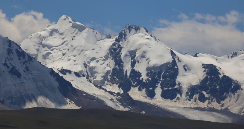
The road from the overnight stay goes up high (H-3060) along the slope, from here there are magnificent views of the Kuylyu valley and the main ridge of the Kuylyu-Too ridge located in the southwest. We will see the peaks of Oroysu Vostochnaya at 4200 meters above sea level, DSO "Zenith" at 4400 and the dominant peak Charlotte at 4605 m. a. s. l.
5 kilometers from the overnight stay, we cross the Sarychat River over a bridge, the area in front of the river is very picturesque, here you can photograph marmot colonies that are not bothered by our presence. Our journey along the Kuylyu River valley ends in the Manasyntash valley, where the Kara-Tor River flows in from the right (3143 m. a. s. l.).
You can still drive literally 300 meters past the bridge over the Kuylyu River, behind the bridge there are two shepherds' houses grazing sheep. There is no road further. Lunch near the huge, picturesque stones on the left bank of the Kuylyu. From our campsite in the south, in the main ridge of the Kuylyu-Too ridge, the second highest peak of the mountain range is clearly visible - Obruchev Peak, 5203.2 m. a. s. l.
To the east, five-thousanders are visible - Amundsen, 5041 m. a. s. l. high, Bogatyr Peak, 5078 m. a. s. l. high, Aksakal Peak, 5028 m. a. s. l. Our journey along the Kuylyu gorge ends, and we return to the Sarydzhaz gorge.
Transfer: Manasyntash valley - Kuylyu river - Sarydzhaz gorge - Inylchek village (75 km).
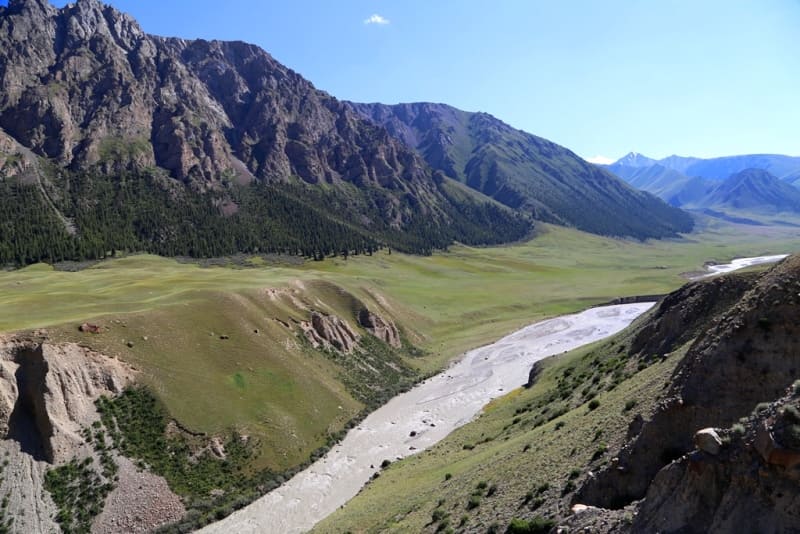
5 kilometers after leaving the Kuylyu gorge, on the left side we will see the confluence of the Kuylyu river and Sarydzhaz. The narrow and grandiose Srydzhaz gorge amazes with its severity, there is enough space in the gorge only for the river and the road. In some places the river is not visible, it is hidden in deep, steep canyons.
About 5 kilometers before the Inylchek village we will make a stop at the penultimate bridge across the Saoydzhaz. In this place, the bridge is built in a very narrow place, by the way, the old one, perhaps the very first wooden bridge, which was under the new bridge, has survived, but which can be seen by going down a little lower to the river.
The next stop is before the bridge over the Inylchek River. This grandiose river, 56 kilometers long, originates from the South Inylchek glacier. The glacier is 6 kilometers longer than the river, its length is 62 kilometers, it is located in the heart of the Central Tien-Shan on the border with the People's Republic of China.
After 1 and 2 kilometers, the river flows into the Sarydzhaz on the left with three branches. About 15 kilometers after the end of the South Inylchek glacier, the North Inylchek glacier adjoins on the right, on which, almost at the junction with the South Inylchek, there is Lake Merzbacher located at an altitude of 3319 meters above sea level.
Every year in the last ten days of July or the first ten days of August, the lake overflows, and water breaks out of it and a stream of water rushes along the glacial channels of the South Inylchek along the bed of the Inylchek River into the Sary-Dzhaz River.
This is a grandiose spectacle, the river increases several times and the water spreads throughout the entire valley of the Inylchek River and with noise and roar flows into the Sarydzhaz. Immediately behind the bridge is the village of Inylchek.
In 1962, at the confluence of the large and full-flowing rivers Inylchek and Saarydzhaz, in the eastern part of the Central Tien-Shan mountains, a rich deposit of tin and tungsten was discovered, which was called "Trudovoe", which marked the beginning of the construction of this village.
Walks in the vicinity. For the night, we will settle on the right bank of the Sarydzhaz River, among deciduous trees - willows and poplars, for this we will cross the Sarydzhaz River on a metal bridge and settle in a cozy meadow with grass. Dinner, overnight in tents.
Day 5. Inylchek - Ak-Suu village (127 km).
Breakfast. Transfer: Inylchek village - "Kara-Tash" hot spring (6 km).
We will visit a local landmark - the hot spring "Kara-Tash", located on the left bank of the Sarydzhaz River. The water in the spring reaches 57 degrees and in cold weather you can take a bath here. In the summer months, when the water in the river rises, the spring goes under water, at least the approach to it is difficult, you need to walk knee-deep in icy water. Walk in the surrounding area.
Transfer: "Kara-Tash" - Sarydzhaz gorge - Ottuk gorge - Chan-Ashu pass - (50 km).
We return to the mouth of the Ottuk River, go through the formalities of the next border post and head to the Chon-Ashu pass. Before climbing the pass, beautiful views of the glaciers of the upper reaches of the river, where it originates, open up on the right side.
From the pass, a delightful view of the Ottuk River valley opens up. Stop at the pass, walk in the surrounding area.
Transfer: Chan-Ashu pass – Novovoznesenovka, Ak-Suu villages – beginning of Arashan gorge (71 km).
We drive 10 kilometers along the Chon-Ashu River, which flows from the right side into the Turgen-Aksu River in the Kokkiya tract. Throughout the gorge there are yurts and tents of shepherds, and domestic animals graze next to them. We pass the most beautiful gorge in the Terskey Ala-Too ridge and along from the village of Ak-Bulak our path lies to the west.
We pass many villages of the Aksuysky district, the largest of which are Novovoznesenovka, Ak-Suu (former Teploklyuchenka), in the center of the village of Ak-Suu we turn left towards the Arashan gorge. Arrival at the guest house, accommodation, dinner, overnight stay.
Day 6. Ak-Suu - city of Karakol (51 km).
Breakfast. Transfer: Ak-Suu - Arasan gorge - Altyn-Arashan resort (20 km).
We leave the guest house and head for a new journey in the Terskey Ala-Too mountains. The asphalt road surface will still stretch a little beyond the village of Ak-Suu and will soon end. Recently the road has been repaired and filled in some places, but after about 5 kilometers we will encounter an extreme section of the road on the left bank with large stones.
This is one of the extreme roads to the tourist attractions of the Issyk-Kul Lake area. Not far from the Arashan resort there is a climb along the black soil, which also needs to be overcome, even in the rain. Just before the resort there is a small Ortok pass 2300 m. a. s. l.
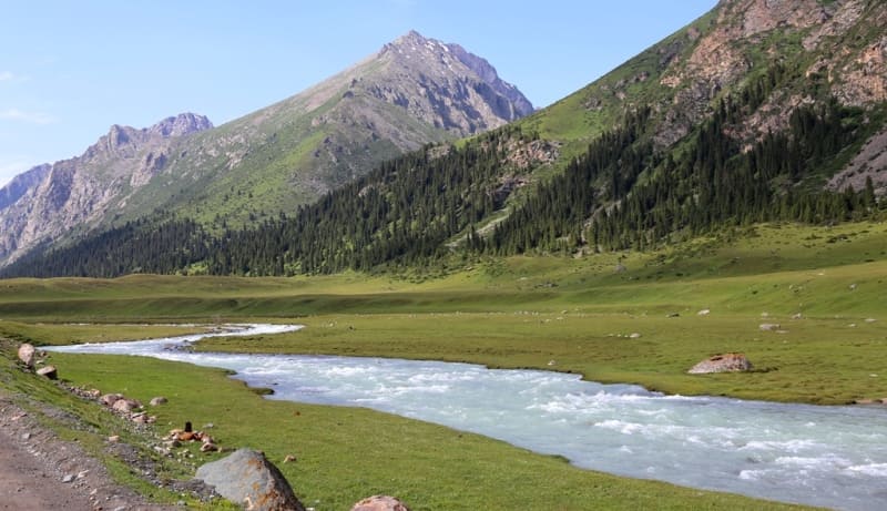
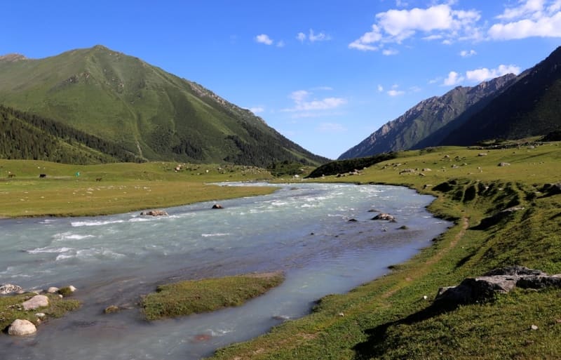
Stops along the way, photographing the surroundings of the Arasan River, which flows in a thin strip in a deep gorge. Arrival at the Altyn-Arashan resort. This is one of the most beautiful gorges in Kyrgyzstan, located on the northern slope of the Terskey Ala-Too ridge.
At the Arasan resort you can swim in natural hot radon springs, and then dive into the cool waters of the Arashan River, which is nearby. Walks in the vicinity of the resort. Thermal springs "Altyn-Arashan" are located in a picturesque valley, in the area of alpine meadows.
In the immediate vicinity of the river there are springs with different water compositions and temperatures. They contain hydrogen sulfide, the water temperature reaches 41, in radon 32 degrees. Here you can take baths all year round, the local healing water treats diseases of the joints, digestive organs, liver, kidneys, heart.
From the resort to the southeast and further to the southwest leads a 13-kilometer trail to Lake Ala-Kol. The trail is laid along the left side of the Arasan River, after about 3 kilometers you cross the ford across the Kol-Dike River and begin the ascent along the eponymous gorge to the Ala-Kol North Pass at an altitude of 3893 m. a. s. l.
From the pass there is a magnificent view of the high-mountain, moraine, flowing, freshwater lake Ala-Kol located at an altitude of 3532 m. a. s. l. Traversing the slope along the southern shore of the lake, the trail leads to the sources of the Kurgak-Tor River, on which a picturesque waterfall is located just below, and along the eponymous gorge, tourists descend into the gorge of the Karakol River.
In the vicinity of the healing springs, there are several wooden houses on picturesque meadows on the right along the bank of the Arashan River. To the south, a view opens up of the Palatka peak, 4,733 m. a. s. l., this inaccessible, snow-ice peak looks like a giant white tent dominating the neighboring peaks of Terskey Ala-Too. Lunch.
In the afternoon, transfer: Altyn-Arashan - Arasan gorge - Ak-Suu village - Karakol city (31 km).
Arrival in Karakol, hotel accommodation, dinner, overnight.
Day 7. Karakol.
Breakfast. Karakol (translated from Kyrgyz - "black hand"), is the administrative center of the Issyk-Kul region. In the autumn of 1869, the garrison from the Aksuu fortification, which served as the center of administration of the Issyk-Kul district, was transferred to the Karakol River.
Thus, a new fortification was founded, which received the name of the river on which it is located. The fortification was founded as a military and administrative center on the caravan road from the Chui Valley to Kashgaria by Staff Captain Baron Kaulbars.
The city changed its name several times: until 1889 it was called Karakol, then it was renamed by decree of the Tsar to the city of Przhevalsk, in honor of the famous Russian traveler N. M. Przhevalsky, who died on his way to his 5th journey in 1888 in Karakol.
According to his wishes, he was buried on the shore of Issyk-Kul. In 1922, the city was given back its former name. And in 1939, in connection with the centenary of the birth of N. M. Przhevalsky, the city was again called Przhevalsk. The name remained until 1992, then the city was given back its historical name.
Among the cities of pre-revolutionary Kyrgyzstan, Karakol was a city of relatively high culture. From here, participants in numerous expeditions to Central Asia departed, they were famous scientists and travelers. The city developed as a trade and administrative center of the entire Issyk-Kul region.
The population of the city of Karakol is 84,351 (2021) people. The city is truly a center of cultural mixing, representatives of 30 ethnic groups live here, mainly: Kyrgyz, Russians, Uzbeks, Uighurs, Tatars, Dungans, Kazakhs, Ukrainians and others.
City tour in Karakol, visit:
Historical and local history museum, the building is a unique exhibit, a typical example merchant's mansion, in the XIXth century it belonged to the merchant M.N. Ilyin, a famous cattle breeder, and was built in 1889.
Orthodox Holy Trinity Church.
With the organization of an independent Turkestan diocese in 1869, a felt field church was transferred from the village of Teploklyuchenka to the new county town. Until 1876, the so-called koshemnaya church, made of felt and boards, served in Karakol, donated by the military from Teploklyuchenka.
Dungan mosque,
built in 1910. Architect and builder Zhou-Si. 30 people took part in the construction of the mosque, including 10 wood carvers and roofing masters. Built in the traditions of Dungan architecture with slightly curved roofs, it is a one-story building with 42 pillars encircling the walls, arranged in two rows.
Visit to Przhevalsky memorial complex,
which is located 12 kilometers northwest of city of Karakol near village of Pristan Przhevalsk:
- N.M. Przhevalsky's grave (1888),
- N.M. Przhevalsky's monument (1894),
- N.M. Przhevalsky's local history museum (1957),
- Orthodox chapel (1996),
- Kuseyn Karasayev's grave (1998),
- Kuseyn Karasayev's monument (2002),
- Kuseyn Karasayev's museum (2013).
City tour: introduction to the wooden architecture of the city, antique shop, local bazaar, souvenir kiosks, parks and monuments of the city. Architectural heritage of the city and monuments of Russian and classical architecture: building of the girls' gymnasium (XIXth century), house of the merchant Babkin (XIXth century), house of the merchant Zakhar Breusov with preserved internal elements, history of the first headman of Karakol N.M. Barsov who founded an agricultural school and a garden, which is still in use, house of the merchant Fatih Sulaimanov, house of the merchant Karimov.
End of the tour, dinner, overnight stay.
Day 8. Karakol - Bishkek (402 km).
Breakfast. Transfer: Karakol - Tyup village - Cholpon-Ata city - Balykchy city - Boom gorge - Kok-Moinok cafe (254 km). Lunch at the cafe, rest. Further transfer: Kok-Moinok cafe - Kemin city - Tokmok village - Kant city - Bishkek (148 km). Arrival in Bishkek. End of the tour.
Note:
* On the 2nd day of the tour, if desired, you can take a helicopter flight to the South Inylchek glacier (45 min) in good weather. Landing on the glacier on the helicopter pad of the tourist company, a walk in the surrounding area, from here in good weather you can see the highest peaks of the Central Tien-Shan: Pobeda 7439 m. a. s. l. and Khan-Tengri 6995 m. a. s. l. Return to the base camp "Karkara" (45 min). Such a walk lasts 2 - 3 hours in good weather.
Note:
Author program of Alexander Petrov. Copying and introduction from sanction of author.
Photos by:
Alexander Petrov.