


![]()
You are here
Tour of Kendyrly-Sai Canyon and «Tiger Mountains».


Journey through canyons of Almaty region.
"His Majesty was very intelligent, educated, and eloquent, but he also possessed all the prejudices inherent in crowned heads. Moreover, he was a traveling king, meaning he had completely false notions about everything he saw abroad, since such noble travelers are shown everything from its best side, and everything is arranged and organized to create the best possible impression."
Ekaterina Dashkova. "Memoirs of Princess E.R. Dashkova, written by herself. 1876.
Sights of Ili Valley.
Brief description of «Tiger Mountains» and Kendyrly-Sai Canyon trip:
Almaty – Chilik – Baiseit villages – Valley of Castles (Charyn) – Aksai village – Temirlik Canyon – Chundzha village – Koktal village – Atyzhek and Dolantau Mountains – Tiger Mountains – Kendyrly-Sai Canyon – Koktal village, Ili River – Chilik village – Almaty.
Route of distance: 744 km.
Active route length: 5 km.
Season: April 15 to October 15.
Best time for tour: July, August.
Tour duration: 2 days and 1 night.
Detailed itinerary for Syugaty and Ili Valleys:
Day 1. Almaty – Chundzha village (298 km).
Transfer: Almaty – Shelek village – Baiseit village (136 km).
Drive along Seifullin Street, then turn onto Zhunsugurov Street. Soon we cross one of the city's main thoroughfares, Ryskulov Street. We then exit onto Burndayskaya Street, which smoothly merges with the Almaty-Konayev highway. The new three-lane road was commissioned in 2016; the road was originally planned to open in 2015.
Soon, at a small interchange, turn right toward Baiserke village and travel along the new "Khorgos" highway, a road connecting Almaty with Altynkol station south of Khorgos. The road was built as part of the international Western Europe - Western China project. The total length is 304 kilometers.
History of construction of road from Almaty to Altynkol station.
The highway was built from 2012 to 2017 as part of the "International Transport Corridor Europe - Western China" project, in line with Kazakhstan's international commitments. Around 3,000 people participated in the construction. Part of the new road was connected to the Kuldzha Highway.
The Kazakhstani section of the highway begins at the Khorgos International Center for Cross-Border Cooperation (ICBC) on the border with China. The sections of the highway passing through desert and semi-desert zones were protected in a new way: previously, trees were planted along the route; now, the dunes are covered with netting, allowing them to become overgrown and strengthened.
Along the entire route, cattle crossings have been built in some places. A new road bridge has been built across the Ili River, and the old bridge has been reconstructed. After Shelek, there is an interchange with turns to Kegen and Kolzhat. From here, the Charyn Canyon is 25 kilometers across the steppe.
In parallel, in some places the road runs with the Zhetygen - Altynkul railway.
The distance from Almaty to the village of Chilik along the new highway is 128 kilometers. A bypass road has been built through Chilik. After the village of Chilik, we'll cross a bridge over the Chilik River and soon make our first short stop in the village of Baiseit.
Its main street features a large bazaar where you can buy vegetables, fruits, produce, fresh tandoor flatbreads (including onion-filled ones), samsa, and pirozhki (pies). You can also enjoy a delicious meal at the numerous cafes and canteens offering a variety of Kazakh, Uyghur, Dungan, and Russian cuisine.
It's worth noting that this is the second best place to eat after Almaty if you're traveling along the new highway. Of course, Chilik is the first choice, but Chilik is rarely visited; most people go to Baiseit to eat and visit the local bazaar. A traditional stop in the village, in addition to the bazaar and local cuisine, you can visit local attractions: the village Community Center with interesting and beautiful bas-relief panels, monuments to Ismail Tairov and Seyit Muhammad Kashi, and a monument to Victory in the Great Patriotic War.
Transfer: Baiseit - village Nura – Kokpek Gorge – Syugaty Valley – canyon and Valley of Castles in Toruaygyr Mountains (70 km).
The rest of the journey leads through the small Sogety Range, along the narrow Kokpek Gorge, 11 kilometers long. The Sogety Range separates the Ili River Valley from the large, latitudinal Trans-Ili Alatau range. Gradually, the Kokpek Gorge widens and flows into the Syugatinskaya Valley, which is bordered by the Sogety Range to the north and the Toruaygyr Range to the south.
Syugaty Valley stretches from west to east, with the Ili River as its northernmost boundary and the Charyn River valley as its southwestern border. After passing the Syugatinskaya Valley, the road begins to deepen into the Alasy Gorge, which cuts through the Toraygyr Range from north to south.
We turn left onto a dirt road leading to the natural landmark of Castles Canyon. From here, the canyon is 11 kilometers away.
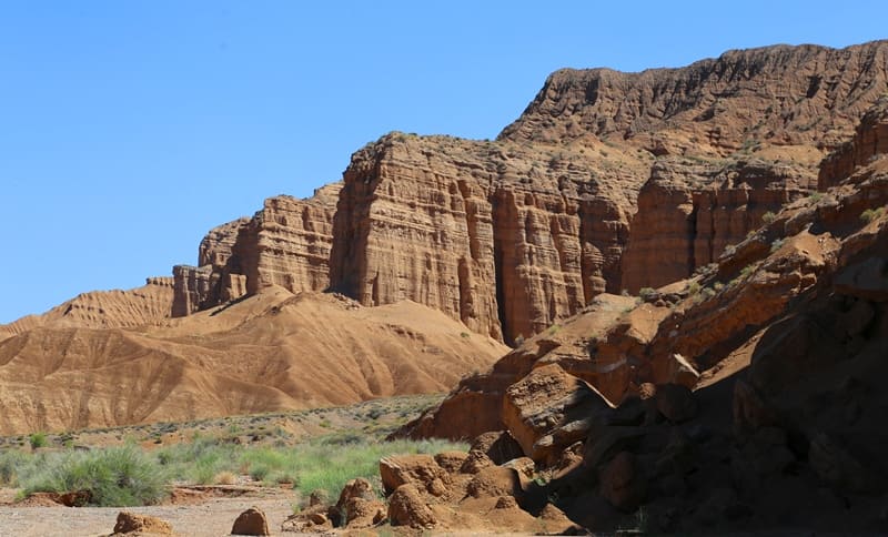
Arrival at the Valley of Castles Canyons.
A walk along the canyon to the Charyn River. Charyn Canyon is a complex of palaces, towers, and minarets. The gorge attained this appearance approximately half a million years ago. This is how the "Valley of Castles" emerged - one of the masterpieces of natural architecture.
Numerous fossil remains dating back to the Lower Carboniferous period, approximately 300 million years ago, are found on the slopes. Since prehistoric times, the waters of the Charyn River, the largest tributary of the Ili River, have carved a channel through the rock, wearing away the stone and forming a huge passage in the cliffs.
The Charyn Canyon is a unique natural complex in Kazakhstan, stretching for approximately one hundred kilometers. End of the walk.
Transfer: natural landmark of Castles – Toraigyr Mountains – Kurtogay natural landmark (35 km).
This is one of the best, most picturesque, and accessible spots in the Charyn River Canyon. The gorge covers an area of 270,608 square meters, with a perimeter of 2,132 meters. At this point, the Charyn River's channel reaches an altitude of 1,060 m. a. s. l.
The canyon is up to 200 meters wide, and the river makes an intricate zigzag from the bridge to the end of the gorge. If you're driving from Almaty toward the village of Kegen, you'll need to travel 3 kilometers and 635 meters from the turnoff for the villages of Zhalanash and Saty to the Charyn River.
A walk in the surrounding area. About 700 meters before the bridge, just before the right bend in the road and the descent, turn left from the highway onto a dirt road. This dirt road, after about 500 meters, will lead you to the panoramic viewpoint of the Kurtogay valley.
Transfer: Kurtogay valley - Aksai village - Temirlik River and Canyon (21 km).
We'll pass the bridge over the Temirlik River and soon stop at a picturesque spot in the river canyon, from where it offers a clear view to the north and south. Temirlik Canyon is 25 kilometers long, with its mouth at an elevation of 865.8 meters above sea level, where it joins the right-bank part of the Charyn Canyon.
The Temirlik River is the last major tributary of the Charyn River. The foothill plain of the northern slopes of the Kuluk-Tau Mountains and the Ketmen and Shoshanai ranges is composed of red clay deposits mixed with rubble and rock remnants exposed by the Temirlik River. A short walk in the surrounding area.
Transfer: Temerlik Canyon – Chundzha village (36 km).
After a stop for a walk, the road turns sharply south and after 2 kilometers turns north again, gradually ascending onto the foothill plain. We pass the successive tracts of Don-Korasay and Kamysh-Korasay, the road turns northeast, and soon we reach the southern tip of Chundzha.
Transfer to a guesthouse, check-in, dinner, and overnight.
Day 2. Chundzha – “Tiger Mountains” - Kendyrly-Sai Canyon - Almaty (446 km).
Breakfast. Transfer: Chundzha - Tash-Karasu village - Ili River - Koktal village - Atyzhek Mountains and “Tiger Mountains” (104 km).
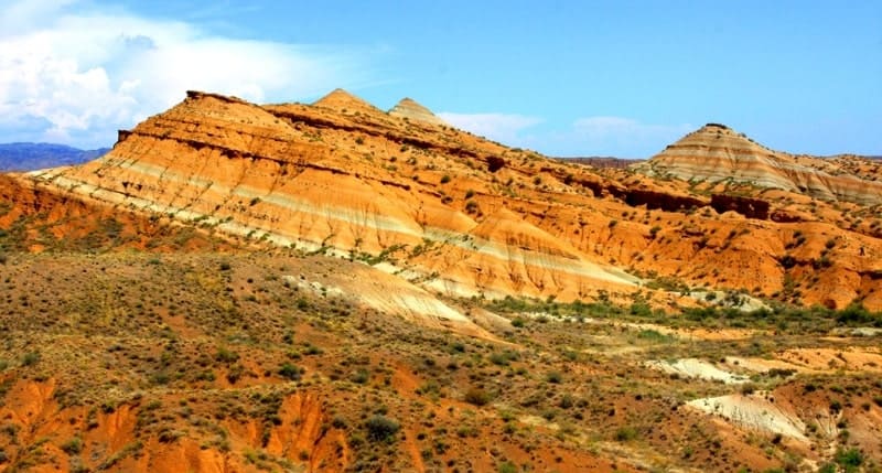
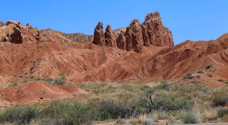
The mountain topography has a complex geomorphological structure, formed under the influence of tectonic, erosional, denudation, and accumulation processes. “Tiger Mountains” mountain range is characterized by dry, gently sloping ravines and small valleys with steep, smooth slopes.
There are outcrops of weathered rock that form ridge-like formations cut by numerous small, dry streambeds. The mountains are composed of chalk deposits with a variety of colors, offering interesting and picturesque landscapes of rare beauty. A walk in the vicinity of the “Tiger Mountains”.
Transfer: “Tiger Mountains” - Koktal-Saryozek Highway - Kendyrly-Sai Canyon (27 km).
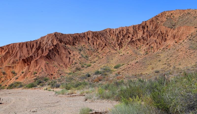
We return to the highway, drive 3.5 kilometers toward Koktal, and turn left along the dry bed of the Kendyrly-Sai River, slowly ascending to the upper reaches of the canyon. The canyon bed is dry throughout the year, and streams flow here only in spring and during rainy seasons.
The gorge is home to numerous hares, often moving swiftly through it. Encounters with goitered gazelles (Kazakh: karakuyruk) are also common here, so keep your camera ready. The fast running, jumping, and graceful animals quickly disappear. Rock partridges (Turkish: chukar) are also quite common.
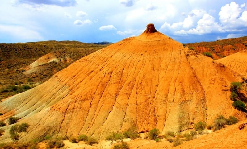
There are usually several in a flock, and in the fall, the female accompanies her offspring. Sometimes, a flock can contain up to 15 individuals. On one of our trips, we counted 38 hare encounters. Kendyrly-Sai is located in the eastern part of the Ili Basin and is a natural extension of the "Tiger Mountains" – a unique region of Cretaceous and Neogene deposits.
These rocks formed in an ancient inland sea, later transformed into a freshwater lake. The waters receded, and the sedimentary strata were subjected to tectonic movements, erosion, and wind weathering, giving the canyon its characteristic shapes: narrow gorges, ridges, "mushrooms," and ribbed cliffs.
The geological composition is represented by conglomerates, sandstones, marls, and gypsum inclusions. The vibrant color palette of the slopes is the result of the oxidation of iron-bearing minerals, clay layers, and organic remains of ancient flora. A walk in the vicinity of Kendyrly-Sai Canyon. Lunch.
Transfer: Kendyrly-Sai – village Koktal – Ili River - village Chilik - Almaty (315 km).
After a walk through the canyon, we return through Koktal, cross the bridge over the Ili River, and after 76 kilometers, turn right onto the new Almaty-Zharkent highway. After 111 kilometers, we reach the village of Chilik and take the bypass road to Almaty. Arrival in Almaty, end of the trip.


Note:
Author's program of Alexander Petrov. Copying and use of material only with permission of author.
Photos by:
Alexander Petrov.