


![]()
You are here
Inylchek Tau ridge.
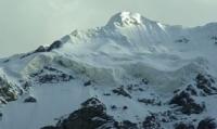
Peaks in Inylchek tau ridge.
“What an open space! What an enchanting beauty in all these snow giants, towering up to the sky! What a variety of colors and tones in these fabulous cliffs of an endless chain of mountains, lost somewhere far, far away. How deeply all this touches the soul and heart of a person! He is seized by such a feeling of delight, which is beyond human strength to describe."
Sergey Kirov.
Sights of Inylchek tau mountain.
Inylchek Tau Ridge is located in eastern part of Central Tien-Shan Mountains, between valleys of South Inylchek in north and Kaindy in south in Ak-Suu district of Issyk-Kul region. The length of the ridge from southwest to east is 55 kilometers, the width in the central part is 14 kilometers.
The western border of the ridge is the Atjailau Zapadnaya River, its mouth is located at an altitude of 2880 meters above sea level and is a right tributary of the Kaindy. In the east, the borders of the Inylchek Tau ridge are the submeridional glacier Komsmomolts with a length of 16 kilometers, flowing down from the northern slope of the Kokshaal-Too ridge.
The northeastern border of the ridge rests on the South Inylchek glacier. In the southeast, the borders of the ridge are the northern slopes of the Kaindy-Katta ridge. In the south and southeast of the Inylchek Tau ridge, the Kaindy glacier extends in a sublatitudinal direction for 25 kilometers.
The dominant peak of the ridge is Shokalsky Peak, 5,722 meters above sea level, located in the eastern part of the ridge. The second highest peak is Nansen Peak, 5,697.2 meters above sea level, located in the central part in the northern spur of the ridge.
From the southern slope of the peak, the Kandzhailau glacier flows down, 10.7 kilometers long. The tongue of the glacier is covered with a moraine cover and is heavily torn. At an altitude of 4,090 meters above sea level, the southern and northern branches of the Kandzhailau glacier merge.
The eastern section of the Inylchek Tau ridge changes its direction, turning first to the southeast, and then to the south, and connects with the longest ridge of the Tien-Shan, Kokshaal Too, in the area of Kirov Peak. The southeastern part of Inylchek Tau serves as a watershed: between the peaks of Kirov and Krasnaya Armiya it separates the valleys of the Komsomolets and Koy-kap glaciers, and the section between Krasnaya Armiya and Shokalsky separates the valleys of the Kaindy glaciers and the tributary of the Komsomolets glacier.
In the eastern part of the ridge there is an extended Shokalsky glacier, 8.2 kilometers long, which is the left tributary of the South Inylchek glacier. The mouth of the Shokalsky glacier is at an altitude of 3515 meters above sea level. The ridge is composed of metamorphic schists, limestones; covered with eternal snows and glaciers.
On the slopes there are numerous rocks and scree, at the foot in the west there is a high-mountain semi-desert.
Geographic coordinates of the Inylchek Tau ridge: N42 ° 08'09.99 "E79 ° 37'00.83"
Authority:
Alexander Petrov.
Photos by
Vladimir Serbenko.