


![]()
You are here
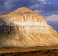
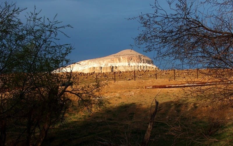
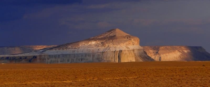
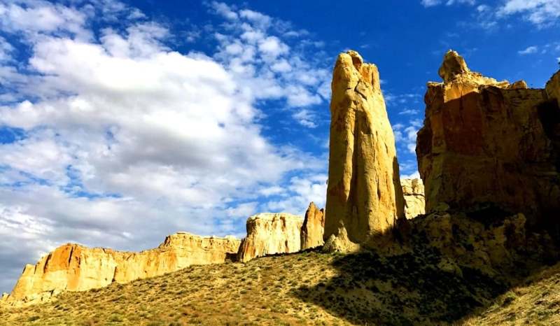
Mount of Sherkala.
Tours 2026 on Mangyshlak.
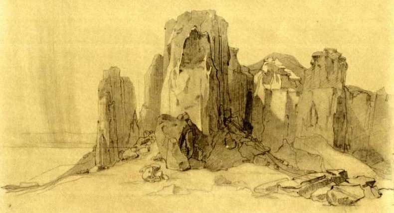
"From a distance, Sherkala resembles sacred Roman pantheons, monuments of ancient times. When you see it, the soul triumphs and rejoices. This is the name of one of the mountains that forms the Ak-Tau complex. The top of the mountain is completely deserted, only occasionally are there weak stems of steppe plants. Rising alone on a completely flat surface, it attracts the attention of the traveler with its form, which distinguishes it from others. The edges of the mountain, more than seven hundred feet high, consist of chalk, clay and coarse-grained gypsum, rise steeply above the plain ... From a distance, Sherkala has the appearance of a compact massif, similar in form (but in colossal dimensions) to the Roman pantheon or some other ancient monument of this kind. As you get closer, you can see pieces of walls that have collapsed, and even individual columns on which statues destroyed by time seem to stand - such bizarre and strange forms of depressions and projections on the uneven cliffs of the chalk mountain."
Album by Bronislav Zalessky. "La vie des steppes Kirghizes", Paris, 1865, p. 57.
" The Chir-Kala cliff is completely vertical... about a verst in circumference. Steps have been made to climb it. At the foot there is a stone fortification. At the top there are traces of dwellings and a deep pit, which probably served as a well. In one of the depressions, which served as a basement, a chain mail coat weighing about 17 pounds was found, it was completely rusty and apparently belonged to a brave warrior, because it was pierced in many places. The rings around the punctured places were so rusty from the caked blood that they could not be cleaned with all their efforts. The Chir-Kala rock is up to 90 fathoms high."
M. I. Ivanin "A Trip to Mangyshlak Peninsula in 1846."
Trip to Sherkala mount on Mangyshlak.
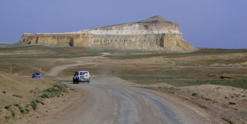
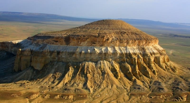
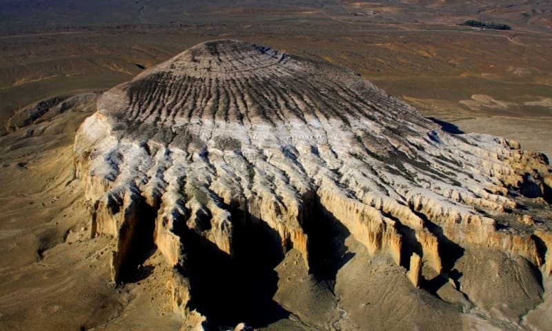
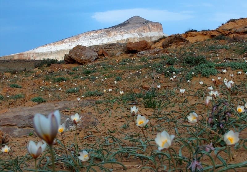
Mount Sherkala, 307.7 m. a. s. l., is located in an intermountain depression between Western Karatau and Northern Aktau ranges, 1.6 kilometers east of dry bed of Akmysh, 21.7 to northeast of village of Zhyngyldy, 17.6 kilometers to northwest of village of Shetpe, 1.7 kilometers to northeast of Kyzylkala ancient settlement, 6.8 kilometers to west and slightly north of Airakty mountain range, in Mangistau district of the region of same name.
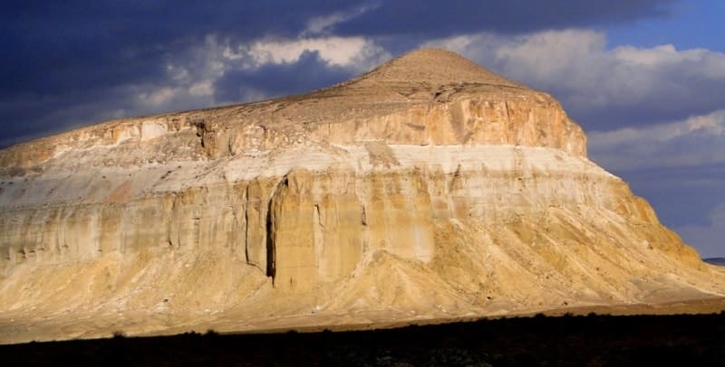
Translated from Turkic, "Sherkala" means "the strength of a lion" ("cher" - a lion, "kala" - a fortress). The geology of Sherkala is represented by Upper Cretaceous rocks, clay, sandstones, marls, and limestones. The mountain is located in the northwestern spurs of the Western Karatau mountain range.
At 1600 meters from the mountain, in the northwest, there is the Kyzylkala hillfort, which dates from the X - XIII centuries and a picturesque green oasis spring and a small stream - Akmysh valley. To the north of Sherkaly there is a hollow between the Western and Northern Karatau mountains, called the vast valley Kurturmas.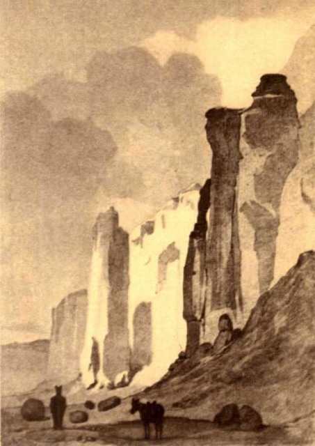
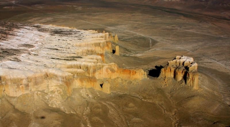
The Kurturmas valley has a length of 15 kilometers from west to east, 4 kilometers from north to south. The height of Mount Sherkala is 307.7 meters above sea level. The giant outlier-witness or table mountain Sherkala is an isolated rock mass that remained on the site of the former plateau after the destruction of the more unstable rocks or exogenous factors surrounding it - weathering, erosion, and water exposure.
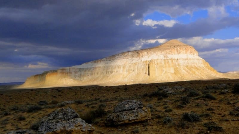
The length of the mountain, from the southern part of the cliff to the longest wedge of the northern part, is 721 meters, the largest, latitudinal width, in the central part of the mountain, is 477 meters. The perimeter of the mountain is 2460 meters.
The southern part of the mountain is the most elevated, 91 meters from the southern edge of the cliff there is a peak on which a class 1 geodesic pyramid is installed. The northern part of the mountain is strongly dissected by vertical and deep ravines.
At 965 meters north of the mountain, an earthen dam was built to collect water, which, during rains, flows from the entire surface of the mountain and, according to its natural slope, rushes north in the reservoir bed. At this time (2020), the artificial dam is destroyed.
Mount Sherkala is a unique sight of Mangyshlak, on the one hand the mountain resembles a huge white yurt, on the other it resembles a sleeping lion with its head resting on its paws. Sherkala translated from Turkmen means “Lion Mountain”.
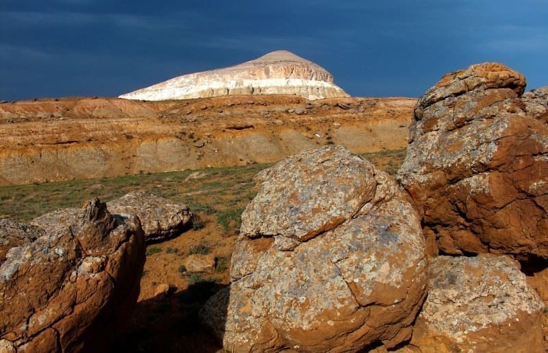
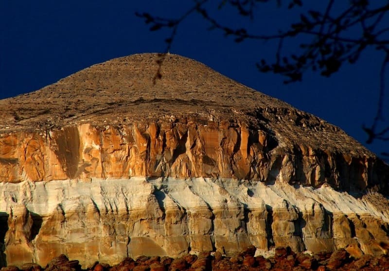
On the south side of Sherkala there is a placer of spherical nodules with a diameter of up to 1.5 - 2 meters (in places up to 3 meters or more). As a result of weathering of sandstone and sand removal, nodules appeared on the surface of the earth, forming clusters in the form of rows of giant balls, sometimes hollow inside (the inner parts of the nodules are blown out).
Many cracked by the wind. Other small nodules are broken. Inside the nodule is a trace of a shell or fish. The limestone slopes of Sherkala are steep and only towards the top of the mountain they become gentle, forming a gigantic tent resembling the top of a yurt.
Climbing the mountain is possible only in one place, on the western side. Here, among the vertical ravines, there is a gentler place that can be dexterous and skilled in climbing rocks. Taras Shevchenko left drawings of Mount Sherkala (Chirkalatau), during his stay on the Mangyshlak Peninsula in the period from VII. 1851 to 13.V. 1857.
In the vicinity of Mount Sherkala, surveying and mining were carried out to search for coal yields and seams in July, early August 1851. Taras Shevchenko painted this mountain from nature. His watercolor is also known, made later on the basis of a pencil drawing.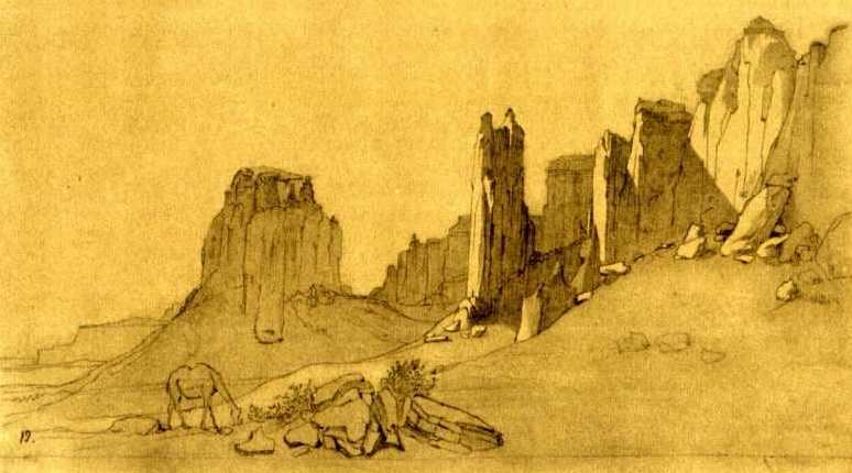
In 1851, Bronislaw Zalessky, in his memoirs, wrote the following about Mount Sherkala:
“This is the name of one of the Cretaceous mountains that make up the Ak-Tau chain. Lonely towering over a perfectly smooth plain, it attracts attention with its outlines and differs from others. Its partitions of chalk, clay and coarse gypsum more than 700 feet high rise perpendicular to the plain.
The legend of the Kirghiz claims that there was a fort at the top of the Shir-kala, the garrison of which for a long time withstood the siege and obeyed only when the enemies, having pulled out an underground passage, reached the well located in the inner part of the mountain.
Having reached the well, the assailants cut off all the ropes on the buckets used in the garrison to draw water, and thirst forced the besieged to surrender. There is no Kyrgyz in the district who does not know this tradition, but no one can accurately name either time or associate it with anyone's name.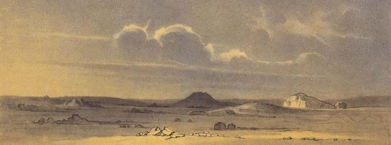
he mountain has in some places traces of a staircase hidden between two partitions. It was not difficult to extrude it, since chalk is an unstable material. The top of the mountain is completely deserted, here and there some kind of frail steppe plant makes its way.
There are no traces of the underground passage, nor the famous well. There are only a few small caves blackened from soot. They must have served as a refuge for the "Dzhigits" (steppe robbers), although in reality the mountain is a real robber's nest.
here recently found old chain mail and several small Tatar coins. From a distance, the Shir-kala seems to be a compact mass, reminiscent of its forms, but on a colossal scale, the Roman Pantheon or some other such great monument of the ancient period. As you approach, the impression is created that you distinguish pieces of ruined walls, even isolated columns, which seem to end with statues ruined by time - the toothed carving of the chalk partitions is so changeable and full of originality!”
Geographic coordinates of Mount Sherkala: N44°15'17" E52°00'22
Authority and photos by:
Alexander Petrov.