


![]()
You are here
Trip from Karakol through Tossor Gorge to Naryn.


Excursion to Tossor Gorge.
"... to the southwest of the lake, sharp peaks of a jagged granite ridge were visible, the slopes of which were whitened with snow. Near these peaks, blocking the view of Talgar Peak, a dome-shaped hill rose, rockier on one side. From here, leaving my horses, with three Cossacks I began my ascent of the dome-shaped hill on foot. Our ascent was very difficult, especially since halfway we were enveloped in a thick cloud and deafened by peals of thunder. But when we finally got out of the thundercloud and reached the top of the hill, all the clouds dispersed, and the sun shone in all its splendor. At the very top I made a hypsometric determination, which gave me 2950 meters of absolute height (on a modern map the height of the mountain is 3453 meters, - author's note). Sopka Kyz-imchek, on which we stood, was the last and highest of the porphyry mountains ... "
P. P. Semenov Tian-Shansky. "Journey to the Tien Shan". 1856.
Short description of journey along southern coast of Lake Issyk-Kul to southern slope of Terskey Ala-Too ridge:
Karakol - Kyzyl-Daikyn village - Tossor village - Tossor gorge - Toguz-Bulak South waterfall - Uch-Emchek river valley - Maly Naryn river - Naryn city - Dolon pass - Kochkor village - Boom gorge - Tokmok village - Bishkek city.
Distance of route: 503 km.
Season: from May 1 to September 1.
Duration of tour: 4 days.
Distance of active part of tour: 5 km.
Best time for tour: July - August.
Detailed program of trip from Karakol through Terskey Ala-Too ridge to city of Naryn:
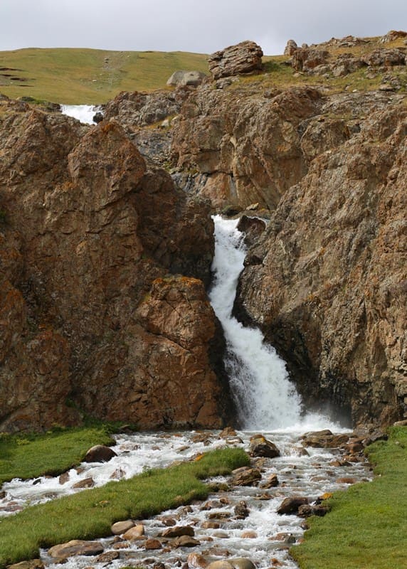
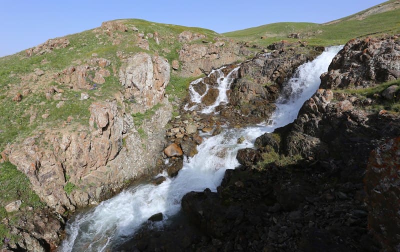
Visit to Toguz-Bulak Waterfall in Uch-Emchek River Valley.
Day 1. Karakol village - Toguz-Bulak South waterfall (135 km).
Transfer: Karakol city - Dzhele-Debe village - Kyzyl-Suu village - Darkhan village - Chon-Dzhargylchak village - Tossor village (97 km).
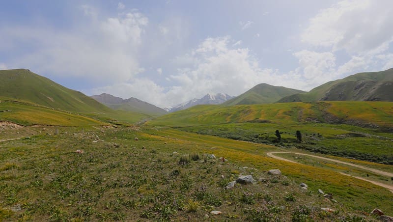
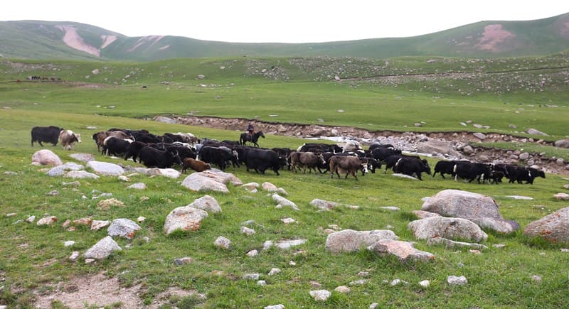
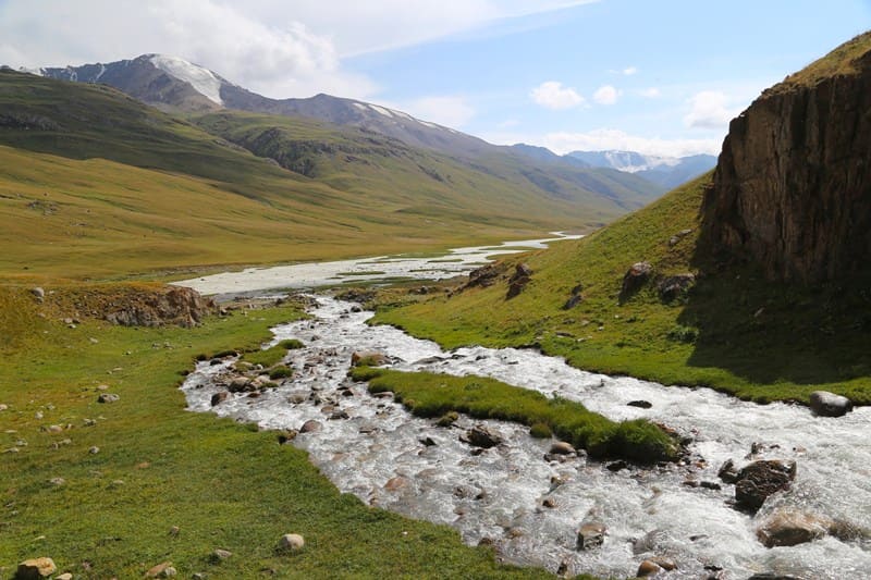
Our route from Karakol lies along the southern coast of Lake Issyk-Kul through numerous villages of the Issyk-Kul region. We pass the village of Tossor and in the Konorchok tract the road turns left into the Tossor gorge.
Transfer: Southern coast of Lake Issyk-Kul - gorge and Pass Tossor (25 km).
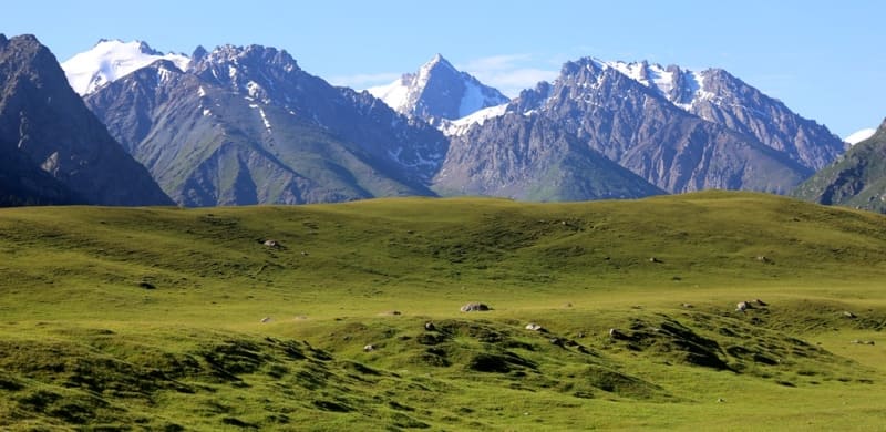
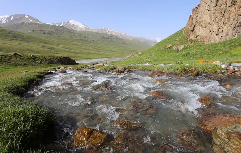
The Tossor gorge stretches in the meridional direction for 28 kilometers, and the river of the same name flows through the gorge. The sources of the Tossor River are located in the highland and alpine zone and then pass into the flat and foothill semi-desert and steppe.
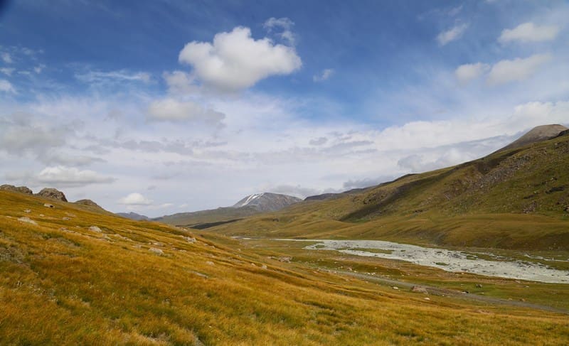
The river flows into the small Tossor Bay on the southern coast of Lake Issyk-Kul. In the upper reaches of the gorge there is a high-mountain pass Tossor, 3893 meters above sea level, located in the main ridge of the Terskey Ala-Too range. On the northern slope of the gorge there are several Tossor glaciers: Central, Western, Eastern, Northern. Lunch on the way.
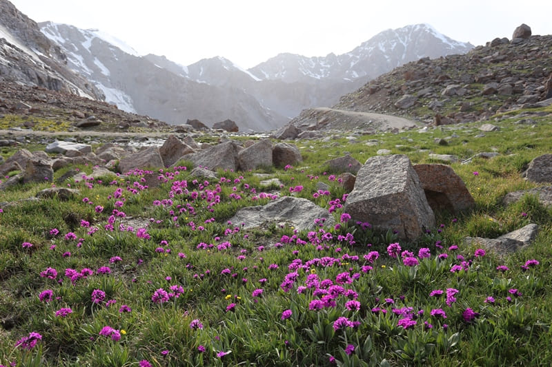
A road runs through the gorge, which leads from the southern coast of Lake Issyk-Kul to Lake Chunkur-Kol, to the waterfall "Toguz-Bulak Yuzhny", which is located on the southern slope of the Terskey Ala-Too range on the right tributary 230 meters before the mouth, to the hot springs of Dzhily-Su, which are located on the left bank of the Uch-Emchek River, to Lake Teshik-Kel, to the valley of the Naryn River, to the city of Naryn.
On the eastern side of the Tossor gorge is the Tamga gorge, on the western side - the Ton gorge. Stop at the pass, walks in the surrounding area.
Transfer: Tossor pass - Toguz-Bulak South waterfall (13 km).
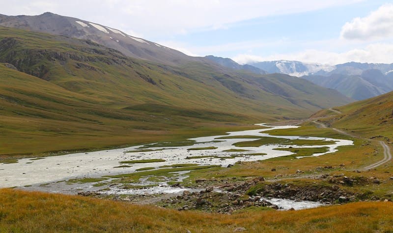
From the pass we move first to the southeast and soon turn to the southwest and move along the right bank of the Dzhel-Tor River along the valley formed by the southern slopes of the Terskey Ala-Too ridge and the northern spurs of the Uch-Emchek ridge.
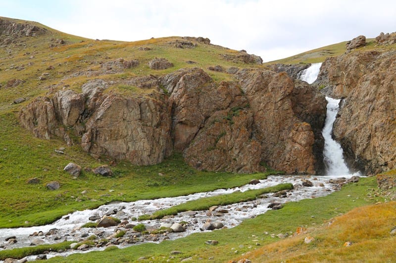
Soon we are at the Toguz-Bulak South waterfall. The river of the same name, overcoming a small rocky spur on its way, formed a tiered, multi-stage picturesque waterfall. After the river laid a narrow, sloping channel in the rock, which meanders when exiting onto a steeper slope of the last rocky terrace, four cascades of falling water are formed.
Walk around the waterfall, climb to the upper terrace, which offers a view of the upper rocky riverbed and the Uch-Emchek River valley Camp in the clearing below the waterfall, on the right side of the river, dinner, overnight.
Day 2. Toguz-Bulak South Waterfall - northern bridge on Maly Naryn River (103 km).
Breakfast. Transfer: Toguz-Bulak South waterfall - Dzhiluu-Suu spring - mouth of Kashka-Suu river (25 km).
We continue our journey along the road laid along the right side of the Uch-Emchek river. We overcome 11 fords across the river beds flowing down the southern slope of the Terskey Ala-Too ridge. Soon we are in the vicinity of the Dzhiluu-Suu thermal springs, on the right bank of the river there is a solid house for vacationers and tourists, where they take hot baths.
From the mouth of the Kashka-Suu river we have to take a 5-kilometer walk to the beautiful, high-mountain lake Teshik-Kol. The lake is located in a swampy intermountain, hilly area. The length of the lake from northwest to southeast is 1.4 kilometers, the greatest width in the central part reaches 544 meters.
The coastline is 3.56 kilometers long, the lake area is 0.59 square kilometers. From the southern part of the lake flows the Kashka-Suu River, 5 kilometers long, and after 650 meters flows into a small, flowing, moraine lake, located at an altitude of 3504 meters above sea level and soon flows from the right into the Dzhiluu-Suu River. Walk in the vicinity. Return to the mouth of the Kashka-Suu River.
Transfer: the mouth of the Kashka-Suu River - the 4th bridge on the Maly Naryn River (78 km).
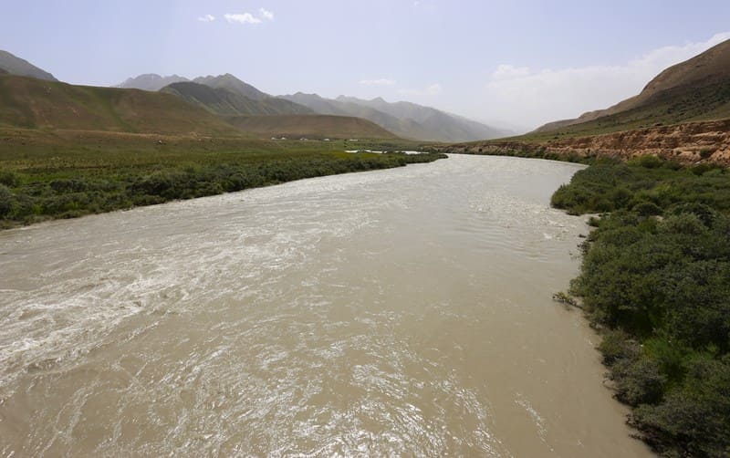
From the mouth of the Kashka-Suu River, the Uch-Emchek River changes its name - now it is called Dzhiluu-Suu, from here the river turns to the southwest and flows along a wide valley. Our path lies along the right side of the Dzhiluu-Suu River.
The Uch-Emchek Mountains end, and the spurs of the Keryu-Karagoman ridge begin in the west. Soon, the Dzhiluu-Suu flows into the Burkhan River, in turn, after the Archala River flows into the Burkhan, the Bolgart River is formed. After the Karagoman River flows into the Bolgart River, the Maly Naryn River is formed.
We will continue to move along the right side of the river, in the vicinity of the village of Tamdy-Suu, we will cross the bridge to the left side of the river. Along the way, we will see majestic pictures of mountain nature against the backdrop of a grandiose river. At all noticeable, interesting places, we will stop and take short walks. Camp in the vicinity of the 4th bridge on the Maly Naryn River, dinner, overnight.
Day 3. Bridge on Maly Naryn River - city of Naryn (32 km).
Breakfast. Transfer: 4th bridge on Maly Naryn River - confluence of Maly and Bolshoi Naryn rivers (16 km).
We continue our journey along the Maly Naryn River. Near the small village of Taldy-Suu, we will make a short stop. Here on the right bank of the river there is an ancient cemetery and a settlement, against the background of adobe structures made of clay, a picturesque view of the river opens up.
Soon a stop at the bridge over the Big Naryn River. Here two full-flowing, great rivers of Central Asia merge, which give rise to the Syr Darya River. The Naryn River flows through the territories of the Issyk-Kul, Naryn and Jalal-Abad regions of Kyrgyzstan, as well as through the Namangan region of Uzbekistan. Walks in the vicinity.
Transfer: confluence of Malyn and Big Naryn rivers - city of Naryn (16 km).
Lunch at a local cafe. Visit to the regional museum named after Kaken Mambetalieva. Among the exhibits of the museum are items of traditional life, national clothing, ancient artifacts and folk art products, kitchen utensils and dishes, agricultural tools, samples of weapons found by archaeologists in the ruins of the fortress of the VIth - Xth centuries Koshoy-Korgon, which reveal the uniqueness of the nomadic culture.
The museum is a significant cultural center of the region, demonstrating the rich historical and ethnographic heritage of the Naryn region and Kyrgyzstan as a whole. After the excursion, we will watch fascinating master classes in the museum:
- "Besh-Barmak show" - where you can learn how to cook this famous national dish of meat and dough;
- "Boorsok show" - where you will be taught the secrets of cooking traditional Kyrgyz flour products, which are fried in oil in a cauldron.
These events will allow you not only to learn more about the culture of Kyrgyzstan, but also to try your hand at cooking national dishes! Visit to the art gallery "AS". The gallery exhibits works by famous artists of the Kyrgyz Republic, including works by G. Aitiev, T. Herzen, S. Chokmorov, J. Kadyraliev and others. In the gallery you can see the works of honored cultural figures and laureates of the Toktogul State Prize, such as S. Azhiev, R. Bukharmetov and T. Usugaliev.
The works reflect the rich cultural heritage of Kyrgyz fine art, combining traditions with modern artistic approaches. Sightseeing tour of the city, visiting: the central mosque of the city (The mosque is named after Azreti Ali (Peace be upon him), which is also called the "Blue Mosque".
The entrance to the mosque is on the eastern side, two wide staircases lead to it, on the opposite side there is another entrance that leads to the madrasah. The mosque attracts with its original architecture, it is decorated with mosaic cladding with rich patterns using graphic and pictorial techniques - traditional Kyrgyz, nomadic embroidery - oimo.
On the right side of the mosque from the entrance there is a towering cylindrical minaret. Visit to the central city square, on the renovated square in 2019 a monument to the outstanding statesman Turdakun Usubaliev was erected in honor of his 100th birthday. The 6-meter-high monument rises in the central part of the city square; one of the domestic businessmen allocated funds for its construction.). Dinner at a local cafe, overnight at the hotel.
Day 4. Naryn - Bishkek (233 km).
Breakfast. Transfer: Naryn - Ottuk village - Dolon pass (67 km).
From Naryn, our path lies to the northwest. In the east there are the Onarcha River and begin to ascend the Ottuk Gorge, along which a transparent, picturesque river of the same name flows. Soon the river gets a new name - Kara-Unkur, we leave the valley of this river and begin to climb to the Dolon Pass, 3038.4 meters above sea level.
From the pass to the north flows the sources of the Sary-Bulak River, which belongs to the Chu River basin, to the southeast flows from the pass one of the right unnamed tributaries of the Kichin-Kara-Kudzhur River, belonging to the Naryn River basin.
The relative heights of the nearby mountain peaks are 200 - 300 meters. The slope facing the north to the Sary-Bulak Valley is gentle, and to the Kichin-Kara-Kudzhur Valley it is steep. The Bishkek - Naryn - Torugart highway is laid through the pass. A walk in the vicinity of the pass.
Further transfer: Dolon Pass - Kochkor (55 km).
We descend from the pass to the northwest, pass the Kumbel Mountains in the west, in the east the Ak-Tash spurs in the Kara-Dzhilga ridge. Then we move along the valley of the Sary-Bulak River, in the west there are the beautiful Keng-Sau Mountains, near the village of Sary-Bulak the valley of the John-Aryk River begins, which merges with the Kochkor River and forms the Chu River.
At the end of the Kochkor Valley is the village of Kochkor. Lunch at a local cafe. Visit to the Kochkor District Museum of History and Local Lore named after Osmonaaly Sydyk Uulu.
Transfer: Kochkor - Kubakty Pass 2161 meters above sea level (25 km).
From Kochkor our route lies to the north-east, the valley of the Kochkor River ends, and we enter the narrow gorge of the Chu River, formed by the Karatau Mountains in the east and Kuvaki in the west. Soon one of the roads turns to the east towards the village of Ottuk and further to the southern coast of Lake Issyk-Kul.
We turn left and soon stop at a small platform from where one of the most beautiful views of the Orto-Tokoy reservoir, formed by the Chu River, opens up. The waters of the river settle in the reservoir and continue to flow along the Boom gorge and further into the northern steppes of Kazakhstan.
Transfer: Kubakty Pass - Boom gorge - villages of Kemin, Tokmok, Kant - Bishkek (164 km).
After the Boom gorge our route lies to the west. Arrival in Bishkek. End of tour.


Note:
Author program of Alexander Petrov. Copying and introduction from sanction of author.
Photos by:
Alexander Petrov