


![]()
You are here
Vasily Shishkin on minaret in Jar-Kurgan.

Jar-Kurgan minaret in village of Minor.
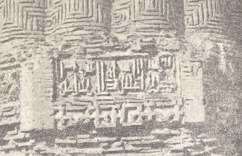
"(1) The emir erected a mosque and minaret as a sacrifice to Allah the Almighty...
(2) the mosque and minaret,
(3) the renowned Ispahsalar,
(4) the great seyyid, protector of justice,
(5) the pillar of the state and religion,
(6) the patron of Islam and Muslims,
(7) the emir of Khorasan, Abu Said,
(8) ... assistant to the emir of the faithful"
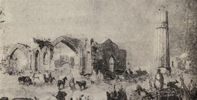
Drawing of Jar-Kurgan minaret by artist N.N. Karazin.
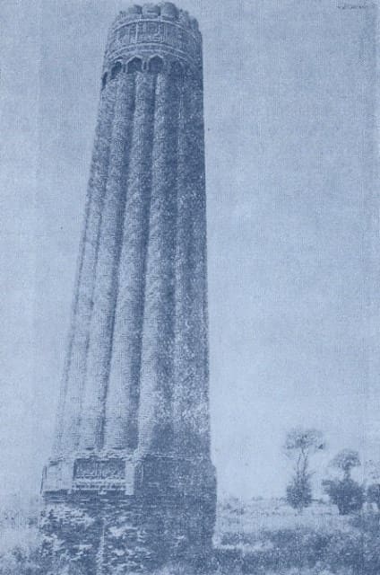
The slender and graceful silhouette of the Jar-Kurgan minaret, rising near the railway line about two kilometers from the modern district center, has long attracted the attention of researchers. In 1900, V. V. Bartold suggested that this "tower of baked brick, approximately 40 arshins high and approximately two fathoms in diameter" stands on the site of ancient Samarkand or Charmangan, as reported by geographers of the IXth-Xth centuries.
As early as the 1870s, the minaret, along with the then-preserved remains of the buildings rising next to it, was sketched by the artist N. N. Karazin, who was part of the so-called "Samara Scientific Expedition." 2; in 1902, the minaret was photographed by engineer B. N. Kastalsky. 3
Karazin's drawing and Kastalsky's photograph are the oldest iconographic materials relating to the monument under study. The Jarkurgan Minaret has also been described numerous times in Soviet-era scientific literature. The most detailed description was by B.N. Zasypkin, who measured the minaret in 1927, determining the height of the remaining portion to be 21.7 meters, with an upper diameter of 4.1 meters.
That same year, V.L. Vyatkin partially deciphered one of the inscriptions, which contained the name of the minaret's builder - Ali, son of Muhammad II. In 1938, the Termez Archaeological Complex Expedition, under the general direction of M.E. Masson, included a new survey of the minaret, conducted by the author of this article together with the architect G.A. Pugachenkova.
At the same time, the inscriptions on the building were deciphered, and a portion of the structure located below current ground level was partially examined to identify the plinth and foundation. In 1948, the Department of Architecture of the Uzbek SSR carried out work to reinforce the minaret to prevent further damage.
The work was carried out by V. P. Petrov. At the same time, the architect A. K. Lazarev took new measurements of the monument. The minaret is located on slightly hilly terrain, currently occupied by cotton fields, melon fields, and tree plantations, which encroach on the monument itself from all sides.
Judging by previous photographs, these plantations and crops occupied the vast, hilly wasteland adjacent to the minaret as early as the late 1920s. Even more striking are the changes in the surrounding area compared to what was recorded in Karazin's drawing, which depicts the ruins of a large monumental building with numerous pointed arches, niches, and passages to the left of the minaret.
In the distance, beyond the minaret, the remains of a significant domed structure are visible. Apparently, at the end of the last century or the beginning of this century, no traces remained of any of these structures - they were dismantled by the local population, who even removed the foundations of the existing buildings.
By questioning local residents, it was possible to determine the changes in the surrounding area compared to what was recorded in Karazin's drawing, which depicts the ruins of a large monumental building with numerous pointed arches, niches, and passages to the left of the minaret.
In the distance, beyond the minaret, the remains of a significant domed structure are visible. Apparently, at the end of the last century or at the beginning of this century, no traces remained of all these buildings - they were dismantled by the local population, who even took the foundations of the buildings that existed here.
By questioning local residents, we discovered that in ancient times there were many baked brick structures around the minaret. The largest of these was located next to the minaret, to the south, and was apparently the mosque around which the current minaret was built.
Furthermore, according to the same people, there were long corridors, brick-lined hauzes, and other structures occupying a vast area. The ruins were called Gulgula.1 The large number of monumental buildings, some of which remained in ruins within the memory of old-timers, testifies to the existence of a significant city on this site.
However, the nature of the terrain seems to contradict this: there are no particularly noticeable elevations, characteristic of all ancient Central Asian cities, which are always visible from afar as more or less massive hills. We also did not discover any noticeable cultural layers in the places where they could be traced.
The resulting contradiction can be resolved, it seems to us, only by assuming that the structures erected in the area described arose within a relatively short time and that their use was also very brief. In other words, we are dealing here with some kind of ephemeral city, perhaps founded by some unknown ruler or briefly ruling dynasty, then abandoned and neglected.
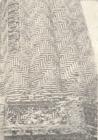
Therefore, V.V. Bartold's suggestion that the Jarkurgan minaret stands on the site of ancient Sarmangan can hardly be accepted. The base of the minaret is octagonal. The center of each face is pierced by a small, narrow decorative niche, semicircular in cross-section, with a pointed apex.
The top of the edge above the decorative niche is designed as a rectangular frame, enclosing part of an inscription laid out of cut terracotta tiles and running along the top of the plinth. The content of this inscription, as far as we could read it, is given below.
The entire remaining free space of the edge is filled with a simple design formed by the decorative arrangement of bricks protruding from the wall surface, the same type used to construct the entire building. Currently, only the upper portion of this decorative arrangement remains intact; the lower portion suffered significant damage and destruction in 1938.
The walls of the octagon are now 1.5 m deep. Below this, the plinth transitions into a foundation projecting 25-30 cm. The foundation is made of baked bricks laid with a gray mortar, reminiscent of the "Kirov" mortar of the Termez "embankment" 1.
The foundation was uncovered to a depth of 1.5 m, but was not fully traced. Therefore, the overall depth of the foundation remains unclear. In the pit, to a depth of 80-100 cm, there was a loose, but difficult to shovel, rubble of construction debris: baked bricks, alabaster, and fine earth.
Fragments of figured, hewn bricks from the cladding of the minaret itself were often found. Fragments of ceramics were found only in the upper part of the layer; they are no older than the last century. This entire layer undoubtedly formed during the destruction of the structures around the minaret.
Below is a layer of relatively dense clay, layered, as if compacted. Charcoal and pieces of brick are found, though very rarely, in the clay. At a depth of about 1.5 meters below the ground surface, denser clay begins, in which neither charcoal nor ceramics have been found.
The minaret rises above an octagonal plinth in the form of an upward-tapering column, the surface of which is formed by sixteen semicircular cords or ribs. These ribs, also tapering upward, diverge slightly at the bottom, near the plinth, as if revealing the round body of the minaret, and come together more tightly at the top, where they are connected by pointed arches.
The tympanums of the arches are filled with a simple pattern of alternating terracotta circles and bows in a checkerboard pattern. Above the arches, the minaret's body is encircled by a wide band of inscription, laid out in the same manner as the inscription on the plinth, using terracotta tiles and framed at the top and bottom by identical ornamental bands, alternating circles and rather intricate terracotta bows.
Above the band with the inscription, a second, upper section of the minaret has been preserved to a very small height, also formed by sixteen semicircular ribs, continuing those of the lower tier. The minaret's ornamental decoration is further enhanced by the meticulously smooth laying of the ribs in a herringbone pattern, where horizontally laid bricks alternate with vertical ones, reminiscent of the weave of a single-row canvas.
All this impresses with the exceptionally high quality of the construction work, the extreme clarity and precision, and the almost flawless austerity of the overall form and detail. The silhouette of the minaret receives a great softness of lines thanks to a very slight barrel-shaped swelling, which can be compared with the entasis of ancient It can be seen from all sides and is unlikely to have resulted from deformation of the structure over time.
Most likely, we are dealing here with a subtle artistic technique dictated by the desire to avoid excessively dry, straight lines in the silhouette. The entrance to the minaret is located in the southwestern face of the octagonal base, which distinguishes this minaret from the famous minarets of Bukhara and Vabkent, whose entrances are located at a considerable height from the ground.
From the entrance, a heavily damaged staircase of baked brick curves upward to the left. The top of the staircase is decorated with masonry consisting of overlapping rows of brick. The surface of the minaret, like all ancient buildings of Central Asia, is covered with a light golden patina - "tan" - and the texture of the brickwork has been well preserved, with the exception of the destroyed base and some recesses and damage in the arches above, under the inscription belt. Furthermore, the minaret gradually deteriorated from above, where, presumably, local residents scavenged bricks for their household needs.
Karazin's drawing depicts the minaret with a significantly better-preserved upper tier, and comparing it with B.N. Zasypkin's data also reveals that the minaret has lost some of its height over the years. Currently, as noted above, as a result of repair and restoration work carried out by the Uzbek SSR's Architectural Department, all damaged areas have been repaired and the monument has been protected from further deterioration.1
It should also be noted that the minaret currently has a slight tilt to the southwest. The deviation of the minaret's axis from the vertical, according to our rough measurements made with a mountain compass, reaches 1.5-2.5 meters. Having set out to publish some new data on the Jarkurgan minaret, we set aside the question of the genesis of this architectural form and will limit ourselves to pointing out the kinship, noted by a number of authors, between its construction technique and decorative-architectural features and a large number of monuments, the remains of which have survived across a vast territory encompassing Khorezm, the Zarafshan Valley, the Termez region, and northeastern Iran, and dating back to the era of the development of feudal relations among the sedentary population of Central Asia.
This era is defined by the chronological framework of the Vth-XIIth centuries, and by the end of this period, the typical features of this early feudal architectural style, as we would call it, already appear in vestigial forms. The most characteristic and easily recognizable feature of this style, even in minor building fragments, is a unique decorative technique of closely spaced semi-columns, connected at the top by semicircular or ellipsoidal arches, and, at the end of the period, by pointed arches.
This feature, as we have seen, is also characteristic of the Jarkurgan minaret. Based on this feature, the monument described was previously associated primarily with Khorasanian monuments: the so-called "tower mausoleums" in Radkan and Ray, and, in part, with the Qaboos Tower.
However, even taking into account that the master who built the minaret, as we will see later, was a master from Khorasan, there is no reason to speak of any Khorasanian influences here: the vast majority of monuments with "corrugated" wall surfaces are located in Central Asia; Here they are the most ancient, and they allow us to trace the historical evolution of this construction technique.
It seems certain that this type of wall decoration was created by Central Asian masters. 1 The emergence of monuments such as the aforementioned mausoleums of Radkan and Ray can be explained by the fact that the construction of the northeastern regions of Iran was closely linked to the Central Asian architectural tradition.
The Jarkurgan minaret is of considerable epigraphic interest. Several inscriptions have been preserved on it, executed, as mentioned above, using a pattern of cut terracotta tiles. The inscriptions are characterized by a strict, clearly drawn Kufi style with minor additional decoration.
The first of these inscriptions, encircling the minaret at the top, above the band of arches, contains the first half of the 18th verse of the 9th chapter of the Quran. The second half of the verse, presumably, was written in a similar band of the lost second tier.
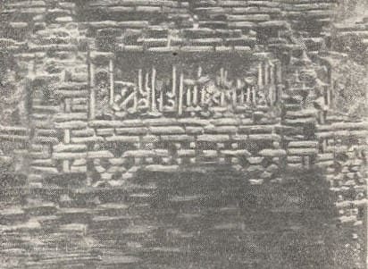
The second inscription, in a rectangular oblong cartouche, is placed on one of the ribs, in a vertical line. This inscription was partially deciphered in 1927 by V. L. Vyatkin, who made out the name of the master who built the minaret, but he could not decipher the final word, which contains a nisba (nickname, usually based on the place of birth) of the builder.
This impeccably preserved short inscription contains the following text: "The work of Ali, son of Muhammad from Sarakhs." Of greatest interest, however, is the third inscription, contained in eight rectangular frames placed at the top of the building's plinth.
Unfortunately, this inscription has also proven to be the most damaged by time. Many letters or parts of them have crumbled; in places, the inscription, in 1938, When we saw it, it was covered in a thick layer of alabaster plaster, into which Arabic letters were carved, so poorly preserved that it was impossible to decipher anything.
In 1948, during renovations, the terracotta inscription was cleared of the remaining plaster, after which V. P. Petrov, who carried out the renovations, produced tracing paper, which the Uzbek SSR Department of Architecture kindly provided to me.
These tracing papers helped in some cases clarify the reading of the inscription and fill in some gaps in my notes. However, it was still impossible to decipher the inscription completely.
The following was decipherable from the inscription:
"(1) The emir erected a mosque and minaret as a sacrifice to Allah the Almighty...
(2) the mosque and minaret,
(3) the renowned Ispahsalar,
(4) the great seyyid, protector of justice,
(5) the pillar of the state and religion,
(6) the patron of Islam and Muslims,
(7) the emir of Khorasan, Abu Said,
(8) ... assistant to the emir of the faithful"
The last three rectangles contained a second line of inscription at the top, laid out using the same technique but in a smaller font. In the sixth and seventh rectangles, the upper lines are so distorted that they are completely illegible; in the eighth, it is better preserved and contains the words:
"five hundred and second,"
the date of the monument's construction according to the Muslim era, corresponding to 1108-1109 AD.
The date we have just read allows us to place the Jarkurgan minaret in its proper place in the history of Central Asian architectural art. Authors who wrote about the minaret, relying solely on a stylistic analysis of the building's features, have not determined the dates with complete certainty and have used different methods. B. N. Zasypkin, followed by B. V. Weimarn, dated the minaret to the XIIth-XIIIth centuries. M. E. Masson, to the XIIIth century. 1 2.
A more accurate date for the minaret was determined by B. P. Denike (XIIth century), relying on historical considerations 3. In later works on the history of Central Asian architecture, the date we have already read is accepted. 4 Significantly more difficult is the question of the identity of the "Emir of Khorasan" by whose order Master Ali of Sarakhs erected this remarkable structure, since the period indicated in the above inscription is very poorly illuminated by available sources. By the time the minaret was erected, the might of the formidable empire of Mahmud of Ghazni and the dynasty he founded had already been broken.
A power struggle raged among the Seljuk sultans among the sons of Malik Shah. The head of the dynasty at the beginning of the sixth century AH was Abu Shuja Muhammad, while the ruler of Khorasan was another representative of the Seljuk dynasty, Sanjar.
Mawarannahr was ruled by Muhammad Arslan Khan, who owed his power to Sanjar's patronage, with whose help he secured his throne and who subsequently supported him on numerous occasions. The only emir of Khorasan entitled to the title indicated in the inscription on the minaret was Sanjar, who ruled the region for nearly 20 years before his accession to the throne in 511-1118.
However, the inscription on the Jarkurgan minaret was not written in Sanjar's name. This is contradicted by the spelling of the letters of the name at the end of the inscription, which we have not fully deciphered. Instead of Sanjar's well-known kuniya, Abu-Harith, the inscription reads Abu-Sa'id.
Consequently, it is impossible to classify this monument as one of Sanjadr's buildings. Muhammad Arslan Khan, whose domains bordered the Termez region on the other side, also could not have been the minaret's builder; his name is not in the inscription, and he could hardly have been called "Emir of Khorasan."
At the same time, the emir's pompous titles to the minaret's builders, the reference to the authority of the "commander of the faithful" - the caliph - at the end of the inscription, as well as the very monumentality of the building, indicate that its builder must have been a very influential person.
Given the paucity of historical information available to us and the difficulty of reading the proper name in the inscription, we will nevertheless attempt to outline, at least tentatively, some historical milestones that could help decipher the origins of the minaret and the city surrounding it.
The surviving version of Narshakhi's "History of Bukhara" 1 preserves information, also transmitted by Ibn al-Athir2, about a Karakhanid prince who claimed power in Transoxiana, whose name is transmitted in a very large number of variants in various manuscripts.
This prince's first act dates back to 1103, when he gathered troops and marched on Samarkand. Thanks to the intervention of Sanjar, who provided assistance to his protege, Muhammad Arslan Khan, and peace was concluded between them.
A few years later, in 508 AH (1109 CE), the aforementioned prince once again rebelled and marched with an army toward Samarkand. Again, with Sanjar's help, Muhammad Arslan Khan defeated his opponent at Pakhshab. The sources cited here provide no information on the location where the pretender assembled his troops, nor on his whereabouts or the period between his two campaigns against Muhammad Arslan Khan and Sanjar.
Only the latter account indicates the location of the battle - near Nakhshab, hence south of Samarkand, from where the road to Termez and Balkh leads. This suggests that it was here, in the southeastern part of modern Uzbekistan, that the pretender's base was located, and where he may have held out after the conclusion of peace between 1102 and 1109.
All of this evidence may not be sufficient to reach a definitive conclusion about the identity of the builder of the city located in the vicinity of modern-day Jar-Kurgan, but it does suggest that it was a Karakhanid pretender, an opponent of Arslan Khan.
This assumption is supported by the aforementioned absence of any significant cultural layers, which could only have occurred if the city had a short lifespan and was abandoned soon after its construction. Thus, if we accept the above assumption regarding the circumstances of the minaret's construction, as well as the city in which it was erected, we gain a new insight into the history of early feudalism in Central Asia - the Karakhanid period, a period far from adequately illuminated by written sources.
This is a relic of one of those feudal wars that rocked Central Asia for centuries, complicating the political situation and thereby delaying the development of the country's productive forces, severely impacting the lives and well-being of the lower working classes.
The minaret at Jar-kurgan testifies to intensified feudal exploitation, perhaps also to the use of slave labor or prisoners of war. Only under these conditions could such grandiose structures, masterfully executed and representing outstanding works of Central Asian architectural art, have been erected in such a short period of time for a temporary and unlikely very powerful prince-pretender.
Additional data for the city's history could be provided by a thorough study of the remains and traces of buildings still preserved in the ground.
Note:
1 Biblioth. geograph. arabic., 1, 339-340; Yakut, 383.
V. V. Bartold, Turkestan during the Mongol Invasion, II, St. Petersburg, 1900, p. 75, with reference to the "Collection of Geographical, Topographical, and Statistical Materials on Asia," v. r VH p. 396.
2 Engraving in "Vsemirnaya Illustratsiya", 1880, no. 608, p. 176.
z B. N. Kastalsky, Historical and Geographical Review of the Surkhan and Shirabadek Valleys, "Vestnik Irrigatsii", 1930, no. 3, pp. 12-13.
4 B. P. Denike, Termez, "Novy Vostok", no. 22, p. 222; ditto, Architectural Ornament of Central Asia, Moscow-Leningrad, 1939, p. 22; B. N. Zasypkin, Architectural Monuments of the Termez Region, "Kultura Vostoka", issue. II, pp. 21, 36 ff., etc. The most recent publication on the monument is B. N. Zasypkin, Architecture of Central Asia, Moscow, 1948, pp. 64-65.
1 B. N. Zasypkin, Architectural Monuments of Central Asia, "Questions of Restoration", II* Moscow, 1928, pp. 278-281. 2 B. H. Zasypkin, Architectural Monuments of the Termez District, p.
1 This common name, meaning "a noisy, lively place," is rather a common noun and was given to various ruins of ancient cities. Local residents do not know the name "Mia," indicated in the caption under Karazin's drawing.
1 The work was carried out in 1948 under the supervision of architect V. P. Petrov.
1 Works by A. I. Terenozhkin and S. P. Tolstova on the monuments of Khorezm. We also discovered the remains of a "corrugated" wall at the Varakhsha settlement in the Bukhara region.
2 Translated by G. Sablukov, 2nd ed., Kazan, 1894, p. 159.
1 B. N. Zasypkin, Architectural Monuments of the Termez Region, p. 36 and Architectural Monuments of Central Asia, p. 281; B. V. Weimarn, Art of Central Asia, Moscow-Leningrad, 1940, p. 35.
2 M. E. Masson, Brief Historical Background on Central Asian Minarets. Proceedings of the Uzkomstaris, issue 2-3, Tashkent, 1933, p. 7.
3 B. P. Denike, Architectural Ornament of Central Asia, p. 24
4 B. N. Zasypkin, Architecture of Central Asia, pp. 64-65.
1 M. Nerchakhy, Description topographique et historique de Bokhara. ed. Schefer, Paris, 1892. pp. 239-240.
2 Ibn-al-Athiri Chronicon, ed. E. Tornberg, Lugd. Batav., 1864, vol. x. 241, 252, 335.
1 Ibn-al-Athir, 335; V. V. Bartold, Turkestan during the Mongol Invasion, Part II, p. 340.
Authority nad photos by:
Vasily Afanasyevich Shishkin. "Minaret in Jar-Kurgan." Proceedings of the Institute of History, Archaeology, and Ethnography of Uzbekistan. Volume II. Publishing House of the Academy of Sciences of the Uzbek SSR. Tashkent. 1950.