


![]()
You are here
Munayly-Mola bitumen deposit.


Tour - a trip to Kazakhstan.
“Here are the Saka graves, like smallpox on the brow
And the silence froze in the sunset crystal
And nearby every year
A herd of herds graze
And past like an arrow
The road ran
At Munaila Mola"
Yuri Pastukhov. Atyrau city.
Online Travel Agency of Kazakhstan.
Geographic location of Munayly-Mola deposit.
Abandoned Munayly-Mola bitumen deposit, located at an altitude of 111 meters above sea level, is 16.1 kilometers northwest of Zhuban Mausoleum, 33.1 kilometers northeast of Akkergeshen chalk plateau, 32.6 kilometers north and slightly east of village of Akkiztogay, 81.3 kilometers northeast of district center of Kulsary, and 56.8 kilometers southeast of Zhanterek railway station in Zhylyoi district of Atyrau region.
Munayly-Mola: a forgotten bitumen deposit in steppes of Zhylyoi district of Atyrau region.
Munayly-Mola is one of the most remarkable and nearly forgotten bitumen deposits in Western Kazakhstan, located between the Aktolagay chalk plateau in the Tolagay tract to the east and the half-dried Kainar Riverbed to the northwest.
The deposit is located within the Caspian Lowland, in a wide, undulating plain where summer air shimmers over clay dunes, and winter winds sweep in from the Caspian.
The elevation, approximately 111 meters above sea level, is typical of the local plains, which slope slightly to the north and northwest. Traces of mining operations are still visible at Munayly-Mola today. Natural bitumen was once mined here, and the resulting excavations left a large pit with extensive patches of solidified black matter.
Several ponds have formed at its bottom, in natural depressions: one is approximately 100 meters long, another is approximately 80 by 50 meters, and a third is quite small, resembling a seasonal puddle.Water is scarce in the area, so these small lakes become an important source of moisture.
In early autumn, huge flocks of migrating larks flock here to drink before continuing their journey. Herds of cows and camels come to the water, and foxes can often be seen along the edges of the pit, successfully hunting birds here. The area is littered with traces of former industrial activity: equipment debris, metal fragments, and masses of hardened bitumen.
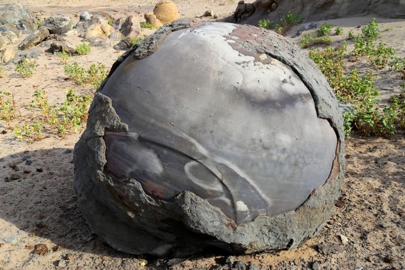
However, the main attraction for researchers and travelers are the spherical stone concretions. Apparently, many of them were brought to the surface by equipment during mining. Their smooth surfaces are partially hidden by a crust of bitumen mixed with sand.
On those spheres where this crust has crumbled under the influence of wind and sun, pure rock is visible - smooth and almost polished. In the depressions of the pit and in the adjacent area, the number of concretions is particularly large. The nearest similar accumulations are widely known in the Mangystau region, in the Torysh tract on the Mangyshlak Peninsula.
However, the Munayly-Mola spherical concretions are the easternmost significant location of their distribution within Kazakhstan.
Small concretions are also found further west at the foot of Mount Imankara, where an old, now abandoned, bitumen deposit is also located. If a traveler heads to the Imankara cave, they can easily encounter these geological evidence of ancient processes that took place in the earth's interior millions of years ago.
Geological origin of Munayly-Mola bitumen deposit.
Munayly-Mola is a natural outcrop of bitumen and heavy oils formed under conditions of long-term migration of hydrocarbons from the deep oil-bearing horizons of the Caspian Basin. Over the course of millennia, oil slowly rose through fractured strata, partially oxidized, evaporated, lost its light fractions, and thickened - turning into thick, viscous bitumen.
This bitumen seeped to surface, filling:
- depressions,
- old temporary streambeds,
- fault cracks,
- erosion troughs.
This is how natural bitumen lenses and dark, shiny "lakes" of solidified oil formed, frozen in the dry steppe.
History of Munayly-Mola field development.
The first information about Munayly-Mola dates back to the mid-XIXth century: local nomads used bitumen as:
- water protection for felt tent coverings,
- resin for repairing leather wineskins,
- a material for treating wooden wagon axles.
In the early XXth century, small mining cooperatives emerged, but due to a lack of infrastructure, production was extremely sporadic. Interest in the field increased in the 1930s - 1950s, when oil exploration was actively underway in the Caspian Lowland.
However, due to the high viscosity of the crude and the difficulty of processing it, Munayly-Mola lost its commercial importance to the lighter, more water-rich oils of Tengiz, Zhetybai, and Kulsary. Since the late 1970s, the field has been completely abandoned, retaining only its unique natural features.
Natural features of Munayly-Mola field.
Landscape around Munayly-Mola is unusual:
- light clayey-chalk ridges alternate with dark patches of bitumen spills;
- sparse vegetation - wormwood, saltwort, feather grass - sets off the harsh nature of the landscape;
- In spring, cranes, little bustards, and small teals can be seen in the drying ridges;
- In summer, the steppe resounds only with the wind.
Munayly-Mola is a place where sedimentary rocks and natural bitumen interacted for millions of years at the bottom of the ancient seabed, forming unusual spherical formations where the rock and bitumen preserve traces of long geological processes.
Munayly-Mola and the surrounding area experience extreme temperatures: in winter, the steppe freezes to a depth of one meter, while in summer, the bitumen lenses heat up to 60 - 70°C, emitting a heavy resinous odor.
Legends of Munayly-Mola.
First legend of Munayly-Mola.
The elders of Akkiztogay said that a great herd of Tulpar-ata, the heavenly horse, once passed through here. Tired of wandering, the horse stepped onto the ground, and its hooves burned the soil, leaving black tracks filled with oily resin.
"These are traces of life's movement," said the aksakals.
"As long as the black blood of the steppe simmers in the earth, man will never forget the road."
Second Legend of Munayly-Mola.
There is an ancient legend that lives among the shepherds of Zhylyoi. They say that when the earth here was still young, a great, formidable whirlwind - Kara-Zhele - swept across the steppe, bringing with it the forces of fire and the depths of the earth.
It tore red-hot lumps of rock from the depths of the earth - the future spherical concretions - and scattered them across the desert plateau. When the storm subsided, the stone spheres cooled under the inexorable sun and transformed into smooth, perfect shapes, as if someone had sculpted them by hand.
Origin of spherical concretions at Munayly Mola deposit.
The scientific explanation is different: for millions of years, the slow and precise "work" of water and minerals took place at the bottom of the ancient Tethys Sea. Thin layers of carbonates and silicates grew around a small core—a shell, a grain of sand, a bone fragment - forming smooth spherical structures.
Then the sea disappeared, the rock layer was uplifted, and time, wind, and Erosion did the rest. But even scientists admit that the perfect shape of these stone spheres truly gives the impression of man-made precision.
Significance of Munayly Mola Field.
Although Munayly Mola has not been developed for a long time, it:
is of interest to geologists as an example of natural bitumen outcrops,
is an observation point for studying the evolution of oil formation in the Caspian Basin,
has scenic and geo-tourist value.
Such a place is not an industrial site, but a living page in the history of the Earth, where one can see how oil is born, ages, and disappears back into the steppe.
A brief scientific overview of spherical concretions of Kazakhstan.
Spherical concretions are mineral formations of a round or nearly spherical shape that form within sedimentary rocks. They form as a result of the concentric precipitation of mineral material (carbonates, siderite, quartz, iron oxides, etc.) around a central core - a grain of sand, shell, bone fragment, or other microscopic inclusion.
Process of spherical concretions formation:
A core-center appears in the sedimentary layer.
Dissolved minerals precipitate around it.
A concentric structure is formed.
Later, erosion or anthropogenic impact brings the concretions to the surface.
Main distribution areas in Kazakhstan.
Region. Nature of formation. Features.
Mangistau (Torysh, Akespe, Sherkala, etc.) Concretions in Cretaceous and Paleogene marine sandstones and siltstones.
Largest and most well-known spherical deposits in Kazakhstan.
Atyrau region (Munayly-Mola, Imankara). Most often associated with oil-bearing and bituminous rocks. Concretions are less common and contain bitumen impurities.
Northern and Central Kazakhstan (Kokshetau, Yesil District). Carbonate nodules in marls. Smaller in size, less perfect in shape.
Most spheres from Mangistau and Munayly-Mola range from 70 to 25 million years old (Cretaceous and Paleogene marine basins).
Comparison of Munayly-Mola and Torysh nodules.
Characteristics. Munayly-Mola (Atyrau Region). Torysh (Mangistau).
Size of spheres. Predominantly small and medium (10 to 70 cm), rarely large (up to 1 meter). Frequently large, often 0.5 - 2 meters, some up to 3 - 4 meters.
Shape. Many "incomplete," deformed spheres due to faults and man-made damage. More regularly rounded, sometimes almost perfect, spheres.
Mineral composition. Sandstones, carbonates, and bitumen impurities. Sandstones, siltstones, ferruginous cements.
Bedding conditions. Associated with man-made excavation pits and erosion. Natural outcrops after rock erosion.
Landscape interior. Steppe desert plateau with man-made traces. Desert plateau among chalk outliers and cliffs - a highly "natural" landscape.
Scientific value. Indicates interaction of sedimentary cementation and bituminous fluids. A world-class reference site for the study of spherical nodules.
Key difference between the Munayly Mola concretions and the Torysh site in Mangistau.
- Munayly Mola - the concretions interacted with bitumen (resin from the subsurface penetrated the sedimentary layers). - Torysh - concretions formed in pure marine sediments, without the influence of oil.
Therefore:
At Munayly Mola, the concretions are often dark, heterogeneous, and partially coated with bitumen.
At Torysh, they are light, dense, monolithic, and have a uniform structure.
A poetic ending to Munayly-Mola.
Munayly-Mola is not simply a forgotten trace of mining and geological exploration.
It is the quiet memory of the steppe, its deep, viscous breath, captured in the black mirrors of bitumen.
Here the wind moves slowly, as if listening to the past.
The rustle of dry feather grass resembles old tales of roads, caravan routes, and nomadic camps.
And the steppe lies flat, wide, like an open book, where every depression is a line,
every clay dune a raised intonation,
every dark lens of bitumen a memory of the ancient fire of the earth.
And if you stop, don't speak, don't rush,
the steppe begins to resonate - deep, low, even.
It speaks of a time that is unhurried.
Of a strength that needs no proof.
Of a patience stronger than storms.
Munayly-Mola is a place where the earth reveals its heart openly.
Not brightly, not proudly, not demanding a glance -
but simply, as the steppe can do everything.
And when a person leaves here, they carry with them not stone, not resin, not clay -
but a warm knowledge:
the history of the world lives not only in words and books,
but also in the silence of the earth.
And everyone who stands here in the twilight, amid the wind and the steppe expanse, feels that
the earth is older than us, deeper than us, and wiser than us.
And we are only guests, passing over its surface.
Geographical coordinates of Munayly-Mola bitumen deposit: N47°31'50 E54°41'36


Authorites and photos by:
Alexander Petrov.